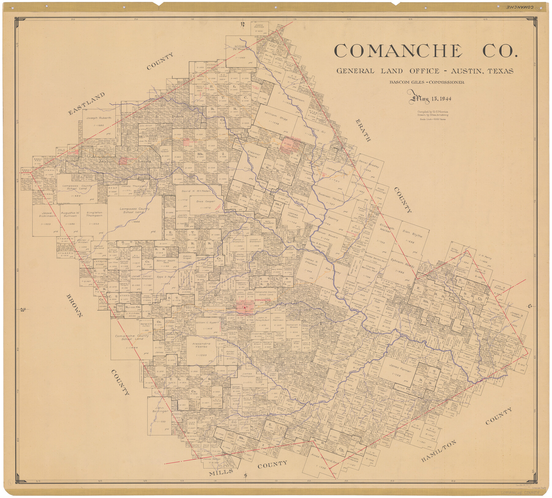
Comanche Co.
-
Map/Doc
73114
-
Collection
General Map Collection
-
Object Dates
1944/5/15 (Creation Date)
-
People and Organizations
Texas General Land Office (Publisher)
Bascom Giles (GLO Commissioner)
Eltea Armstrong (Draftsman)
G.C. Morriss (Compiler)
-
Counties
Comanche
-
Subjects
County
-
Height x Width
42.7 x 46.5 inches
108.5 x 118.1 cm
-
Comments
Hand lettered.
Note on reverse side: "Compilation completed May 15, 1944. Inking completed August 11, 1944. Tracing completed September 23, 1944. Placed in official use September 25, 1944. Replaced [on sticks] by copy June 12, 1946." -
Features
Proctor
Warren Creek
Mountains Creek
White Oak Creek
East Branch of Blanket Creek
Blanket Creek
Mercers Creek
Duncan Creek
GC&SF
Comanche
Joplin Creek
Gentrys Creek
Thompsons Creek
Resleys Creek
Four Mile Creek
Leon River
Walnut Creek
Sweetwater Creek
Moorman City
Sipe Springs
South Copperas Creek
Copperas Creek
Sabanna River
Duster
Comyn
Scotts Creek
De Leon
MK&T
South Leon River
Part of: General Map Collection
Flight Mission No. DIX-7P, Frame 88, Aransas County

Print $20.00
- Digital $50.00
Flight Mission No. DIX-7P, Frame 88, Aransas County
1956
Size 18.7 x 22.3 inches
Map/Doc 83882
Randall County Rolled Sketch 5

Print $20.00
- Digital $50.00
Randall County Rolled Sketch 5
1945
Size 29.7 x 17.6 inches
Map/Doc 7425
Bosque County Sketch File 29

Print $6.00
- Digital $50.00
Bosque County Sketch File 29
1863
Size 12.9 x 8.1 inches
Map/Doc 14816
Waller County

Print $20.00
- Digital $50.00
Waller County
1897
Size 46.0 x 30.2 inches
Map/Doc 63107
Crosby County Working Sketch 6

Print $20.00
- Digital $50.00
Crosby County Working Sketch 6
1912
Size 19.4 x 18.0 inches
Map/Doc 68440
Harris County Working Sketch 113

Print $20.00
- Digital $50.00
Harris County Working Sketch 113
1982
Size 28.6 x 40.7 inches
Map/Doc 66005
Flight Mission No. DQO-3K, Frame 28, Galveston County

Print $20.00
- Digital $50.00
Flight Mission No. DQO-3K, Frame 28, Galveston County
1952
Size 18.1 x 22.3 inches
Map/Doc 85069
La Salle County Working Sketch 46

Print $20.00
- Digital $50.00
La Salle County Working Sketch 46
1981
Size 15.9 x 20.2 inches
Map/Doc 70347
Map of Floyd County

Print $20.00
- Digital $50.00
Map of Floyd County
1888
Size 25.4 x 19.6 inches
Map/Doc 3547
Trinity River, Carl Switch Sheet/Chambers Creek

Print $4.00
- Digital $50.00
Trinity River, Carl Switch Sheet/Chambers Creek
1926
Size 27.9 x 27.0 inches
Map/Doc 65217
Nueces River, Calallen Sheet

Print $20.00
- Digital $50.00
Nueces River, Calallen Sheet
1927
Size 32.7 x 37.3 inches
Map/Doc 65087
Hill County Sketch File 22a

Print $6.00
- Digital $50.00
Hill County Sketch File 22a
1861
Size 11.3 x 9.0 inches
Map/Doc 26509
You may also like

Map of Bee County State of Texas

Print $20.00
- Digital $50.00
Map of Bee County State of Texas
1863
Size 31.1 x 25.3 inches
Map/Doc 3286
Panola County Working Sketch 9

Print $20.00
- Digital $50.00
Panola County Working Sketch 9
1943
Map/Doc 71418
Packery Channel

Print $3.00
- Digital $50.00
Packery Channel
1962
Size 10.7 x 13.2 inches
Map/Doc 3005
Burnet County Boundary File 6

Print $14.00
- Digital $50.00
Burnet County Boundary File 6
Size 14.1 x 8.6 inches
Map/Doc 50886
Ft. Worth & Rio Grande Ry. west from Whiteland in McCulloch County

Print $20.00
- Digital $50.00
Ft. Worth & Rio Grande Ry. west from Whiteland in McCulloch County
Size 35.0 x 46.3 inches
Map/Doc 66908
Parker County Sketch File 37

Print $4.00
- Digital $50.00
Parker County Sketch File 37
Size 4.8 x 8.1 inches
Map/Doc 33581
Water Plant for E. C. Stovall, South Bend, Texas

Print $20.00
- Digital $50.00
Water Plant for E. C. Stovall, South Bend, Texas
1914
Size 37.1 x 24.6 inches
Map/Doc 92142
Cherokee County Sketch File 17

Print $6.00
- Digital $50.00
Cherokee County Sketch File 17
1862
Size 11.6 x 7.7 inches
Map/Doc 18156
Duval County Sketch File 51

Print $20.00
- Digital $50.00
Duval County Sketch File 51
Size 19.1 x 33.8 inches
Map/Doc 11401
Brazoria County Sketch File 1

Print $4.00
- Digital $50.00
Brazoria County Sketch File 1
1861
Size 9.7 x 8.3 inches
Map/Doc 14916
Jeff Davis County Sketch File 36

Print $40.00
- Digital $50.00
Jeff Davis County Sketch File 36
1951
Size 17.1 x 14.3 inches
Map/Doc 28048