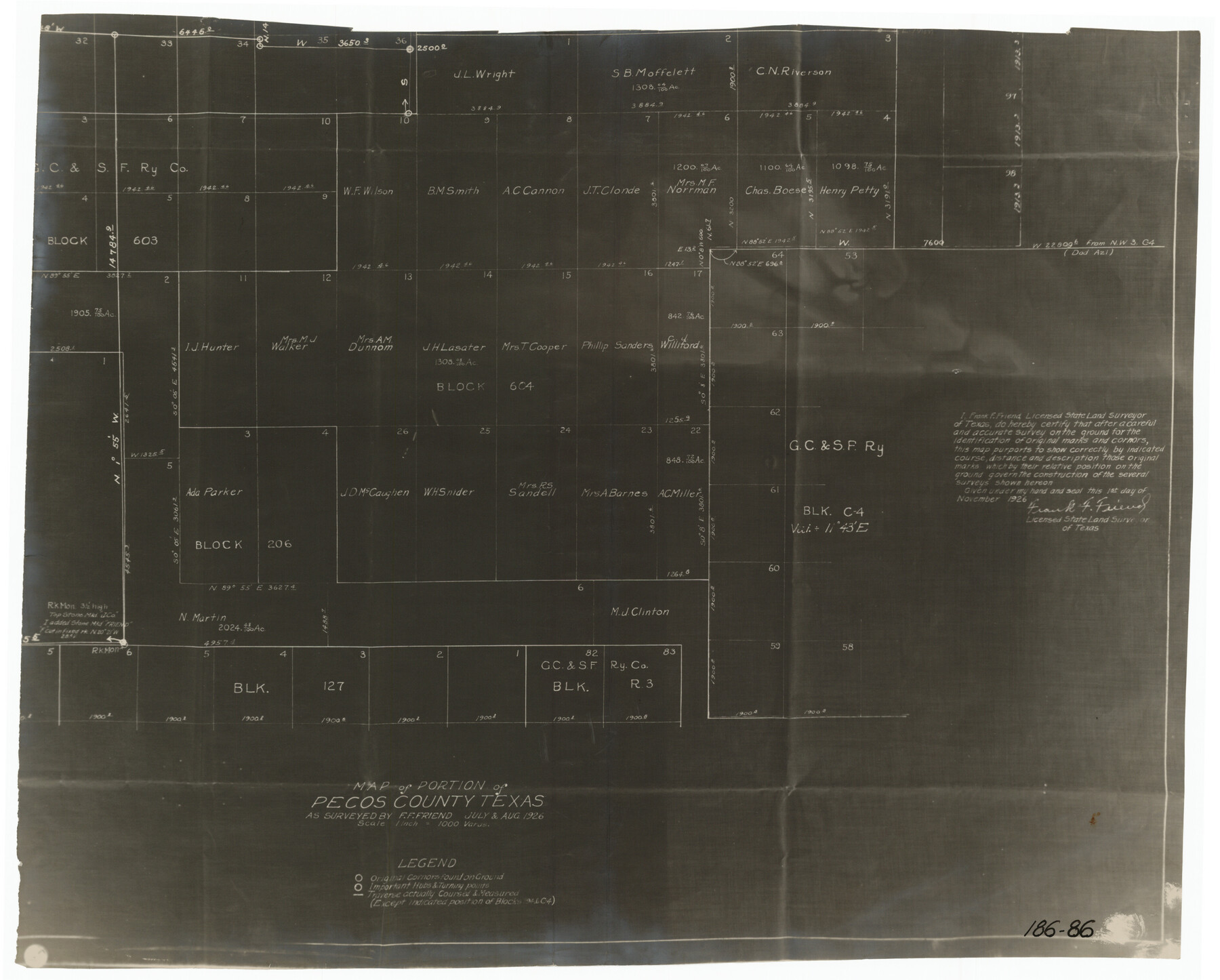
Map of Portion of Pecos County as Surveyed by F. F. Friend
186-86
-
Map/Doc
91561
-
Collection
Twichell Survey Records
-
Object Dates
11/1/1926 (Creation Date)
-
People and Organizations
Frank F. Friend (Surveyor/Engineer)
-
Counties
Pecos
-
Height x Width
18.8 x 15.5 inches
47.8 x 39.4 cm
Part of: Twichell Survey Records
[T. & P. Surveys in Crane, Upton, Coke Counties]
![90464, [T. & P. Surveys in Crane, Upton, Coke Counties], Twichell Survey Records](https://historictexasmaps.com/wmedia_w700/maps/90464-1.tif.jpg)
Print $20.00
- Digital $50.00
[T. & P. Surveys in Crane, Upton, Coke Counties]
Size 19.2 x 21.2 inches
Map/Doc 90464
Sketch Showing Portion of League 4, Wilson County School Land, Lynn County, Texas

Print $20.00
- Digital $50.00
Sketch Showing Portion of League 4, Wilson County School Land, Lynn County, Texas
Size 13.5 x 13.0 inches
Map/Doc 92940
Working Sketch in Lynn County

Print $20.00
- Digital $50.00
Working Sketch in Lynn County
1921
Size 15.3 x 18.6 inches
Map/Doc 91338
[Northwest Garza Co., E. J. Powell surveys and vicinity]
![90852, [Northwest Garza Co., E. J. Powell surveys and vicinity], Twichell Survey Records](https://historictexasmaps.com/wmedia_w700/maps/90852-2.tif.jpg)
Print $2.00
- Digital $50.00
[Northwest Garza Co., E. J. Powell surveys and vicinity]
Size 8.9 x 14.2 inches
Map/Doc 90852
Dawson County Sketch

Print $20.00
- Digital $50.00
Dawson County Sketch
Size 37.0 x 20.5 inches
Map/Doc 92628

[Section 114, Block Z2]
![90371, [Section 114, Block Z2], Twichell Survey Records](https://historictexasmaps.com/wmedia_w700/maps/90371-1.tif.jpg)
Print $2.00
- Digital $50.00
[Section 114, Block Z2]
1907
Size 8.9 x 10.1 inches
Map/Doc 90371
Thomas Ross Survey

Print $20.00
- Digital $50.00
Thomas Ross Survey
1954
Size 16.8 x 17.6 inches
Map/Doc 92181
[Public School Land Blocks]
![93151, [Public School Land Blocks], Twichell Survey Records](https://historictexasmaps.com/wmedia_w700/maps/93151-1.tif.jpg)
Print $40.00
- Digital $50.00
[Public School Land Blocks]
Size 45.0 x 114.7 inches
Map/Doc 93151
[I. & G. N. Block 1, Secs. 65-75]
![90307, [I. & G. N. Block 1, Secs. 65-75], Twichell Survey Records](https://historictexasmaps.com/wmedia_w700/maps/90307-1.tif.jpg)
Print $20.00
- Digital $50.00
[I. & G. N. Block 1, Secs. 65-75]
1928
Size 22.0 x 18.0 inches
Map/Doc 90307
[Rockwall County School Land and adjacent Blocks]
![90759, [Rockwall County School Land and adjacent Blocks], Twichell Survey Records](https://historictexasmaps.com/wmedia_w700/maps/90759-1.tif.jpg)
Print $20.00
- Digital $50.00
[Rockwall County School Land and adjacent Blocks]
1904
Size 16.2 x 12.6 inches
Map/Doc 90759
E. B. Shipp Irrigated Farm East Part Section 32, Block JS

Print $3.00
- Digital $50.00
E. B. Shipp Irrigated Farm East Part Section 32, Block JS
Size 9.3 x 16.7 inches
Map/Doc 92298
You may also like
Bee County Working Sketch Graphic Index

Print $20.00
- Digital $50.00
Bee County Working Sketch Graphic Index
1950
Size 41.6 x 45.4 inches
Map/Doc 76464
Leon County Sketch File 26

Print $20.00
- Digital $50.00
Leon County Sketch File 26
1948
Size 11.4 x 8.6 inches
Map/Doc 29801
Travis County Rolled Sketch 4

Print $20.00
- Digital $50.00
Travis County Rolled Sketch 4
1915
Size 19.7 x 35.6 inches
Map/Doc 8010
[Central Portion of McMullen County]
![91301, [Central Portion of McMullen County], Twichell Survey Records](https://historictexasmaps.com/wmedia_w700/maps/91301-1.tif.jpg)
Print $20.00
- Digital $50.00
[Central Portion of McMullen County]
1884
Size 28.8 x 25.7 inches
Map/Doc 91301
Harris County Sketch File A

Print $4.00
- Digital $50.00
Harris County Sketch File A
1898
Size 12.8 x 8.5 inches
Map/Doc 25306
Burnet County Boundary File 7a

Print $30.00
- Digital $50.00
Burnet County Boundary File 7a
Size 14.1 x 8.5 inches
Map/Doc 50902
Montgomery County Rolled Sketch 38

Print $40.00
- Digital $50.00
Montgomery County Rolled Sketch 38
1962
Size 56.0 x 30.8 inches
Map/Doc 9545
Jeff Davis County Rolled Sketch 31

Print $20.00
- Digital $50.00
Jeff Davis County Rolled Sketch 31
1983
Size 40.6 x 44.1 inches
Map/Doc 9268
Brewster County Working Sketch 1

Print $20.00
- Digital $50.00
Brewster County Working Sketch 1
1904
Size 27.4 x 25.8 inches
Map/Doc 67534
Carta General de la República Mexicana Formada en vista de los datos mas recientes y exactos que se han reunido con tal objeto, y constan en la noticia presentada al Exmo. Sr. Ministro de Fomento, por Antonio García y Cubas

Print $20.00
- Digital $50.00
Carta General de la República Mexicana Formada en vista de los datos mas recientes y exactos que se han reunido con tal objeto, y constan en la noticia presentada al Exmo. Sr. Ministro de Fomento, por Antonio García y Cubas
Size 23.3 x 29.2 inches
Map/Doc 95824
Brewster County Working Sketch 92

Print $40.00
- Digital $50.00
Brewster County Working Sketch 92
1975
Size 61.9 x 39.4 inches
Map/Doc 67692
Franklin County Sketch File 5

Print $2.00
- Digital $50.00
Franklin County Sketch File 5
Size 8.2 x 10.7 inches
Map/Doc 23017