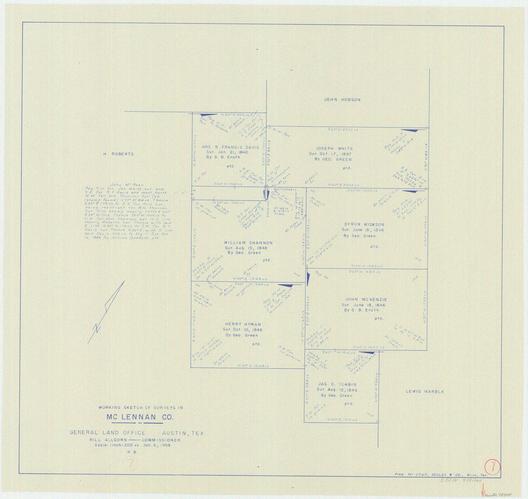
McLennan County Working Sketch 7
-
Map/Doc
70700
-
Collection
General Map Collection
-
Object Dates
1/6/1959 (Creation Date)
-
People and Organizations
Roy Buckholts (Draftsman)
-
Counties
McLennan
-
Subjects
Surveying Working Sketch
-
Height x Width
22.6 x 23.9 inches
57.4 x 60.7 cm
-
Scale
1" = 300 varas
Part of: General Map Collection
Houston County Working Sketch 28

Print $20.00
- Digital $50.00
Houston County Working Sketch 28
1988
Size 30.2 x 37.8 inches
Map/Doc 66258
Runnels County Sketch File 24

Print $20.00
Runnels County Sketch File 24
1930
Size 25.2 x 21.3 inches
Map/Doc 12258
Calhoun County Sketch File 1

Print $7.00
- Digital $50.00
Calhoun County Sketch File 1
1855
Size 17.1 x 11.0 inches
Map/Doc 11031
Flight Mission No. DCL-6C, Frame 126, Kenedy County

Print $20.00
- Digital $50.00
Flight Mission No. DCL-6C, Frame 126, Kenedy County
1943
Size 18.5 x 22.3 inches
Map/Doc 85956
Flight Mission No. BQR-13K, Frame 28, Brazoria County

Print $20.00
- Digital $50.00
Flight Mission No. BQR-13K, Frame 28, Brazoria County
1952
Size 18.6 x 22.4 inches
Map/Doc 84076
Sutton County Sketch File 19

Print $8.00
- Digital $50.00
Sutton County Sketch File 19
1914
Size 11.4 x 8.8 inches
Map/Doc 37447
Caddo Lake Subdivision, Copied from Sketch in MF 000964

Print $20.00
- Digital $50.00
Caddo Lake Subdivision, Copied from Sketch in MF 000964
1918
Size 32.5 x 28.0 inches
Map/Doc 1929
Atlantic Coast to the Rocky Mountains

Atlantic Coast to the Rocky Mountains
1956
Size 42.3 x 29.5 inches
Map/Doc 94410
San Antonio & Aransas Pass

Print $40.00
- Digital $50.00
San Antonio & Aransas Pass
Size 30.4 x 81.6 inches
Map/Doc 64634
Deaf Smith County Sketch File 1b

Print $24.00
- Digital $50.00
Deaf Smith County Sketch File 1b
1902
Size 11.3 x 8.9 inches
Map/Doc 20627
Hardin County Sketch File 56

Print $10.00
- Digital $50.00
Hardin County Sketch File 56
Size 11.2 x 8.7 inches
Map/Doc 25221
Montgomery County Working Sketch 57

Print $20.00
- Digital $50.00
Montgomery County Working Sketch 57
1961
Size 24.2 x 26.6 inches
Map/Doc 71164
You may also like
Hutchinson County

Print $20.00
- Digital $50.00
Hutchinson County
1922
Size 40.7 x 34.8 inches
Map/Doc 77321
Comanche County Sketch File 22b

Print $40.00
- Digital $50.00
Comanche County Sketch File 22b
1872
Size 12.1 x 14.8 inches
Map/Doc 19109

Presidio County Sketch File 104

Print $17.00
- Digital $50.00
Presidio County Sketch File 104
Size 11.3 x 8.7 inches
Map/Doc 34807
Map of La Salle County

Print $20.00
- Digital $50.00
Map of La Salle County
1877
Size 29.7 x 21.6 inches
Map/Doc 3796
Bosque County Working Sketch 7

Print $20.00
- Digital $50.00
Bosque County Working Sketch 7
1942
Size 23.7 x 34.5 inches
Map/Doc 67440
Comanche County Rolled Sketch 1

Print $20.00
- Digital $50.00
Comanche County Rolled Sketch 1
1985
Size 24.1 x 18.7 inches
Map/Doc 5542
Bowie County Working Sketch 16

Print $20.00
- Digital $50.00
Bowie County Working Sketch 16
1961
Size 17.8 x 17.2 inches
Map/Doc 67420
Schleicher County Working Sketch 21

Print $20.00
- Digital $50.00
Schleicher County Working Sketch 21
1953
Size 26.6 x 10.8 inches
Map/Doc 63823
Stonewall County Sketch File 19

Print $20.00
- Digital $50.00
Stonewall County Sketch File 19
Size 33.2 x 33.6 inches
Map/Doc 10392
Hutchinson County Working Sketch 47

Print $20.00
- Digital $50.00
Hutchinson County Working Sketch 47
1980
Size 35.2 x 19.9 inches
Map/Doc 66407
Briscoe County Sketch File H

Print $40.00
- Digital $50.00
Briscoe County Sketch File H
1917
Size 17.2 x 13.2 inches
Map/Doc 11005