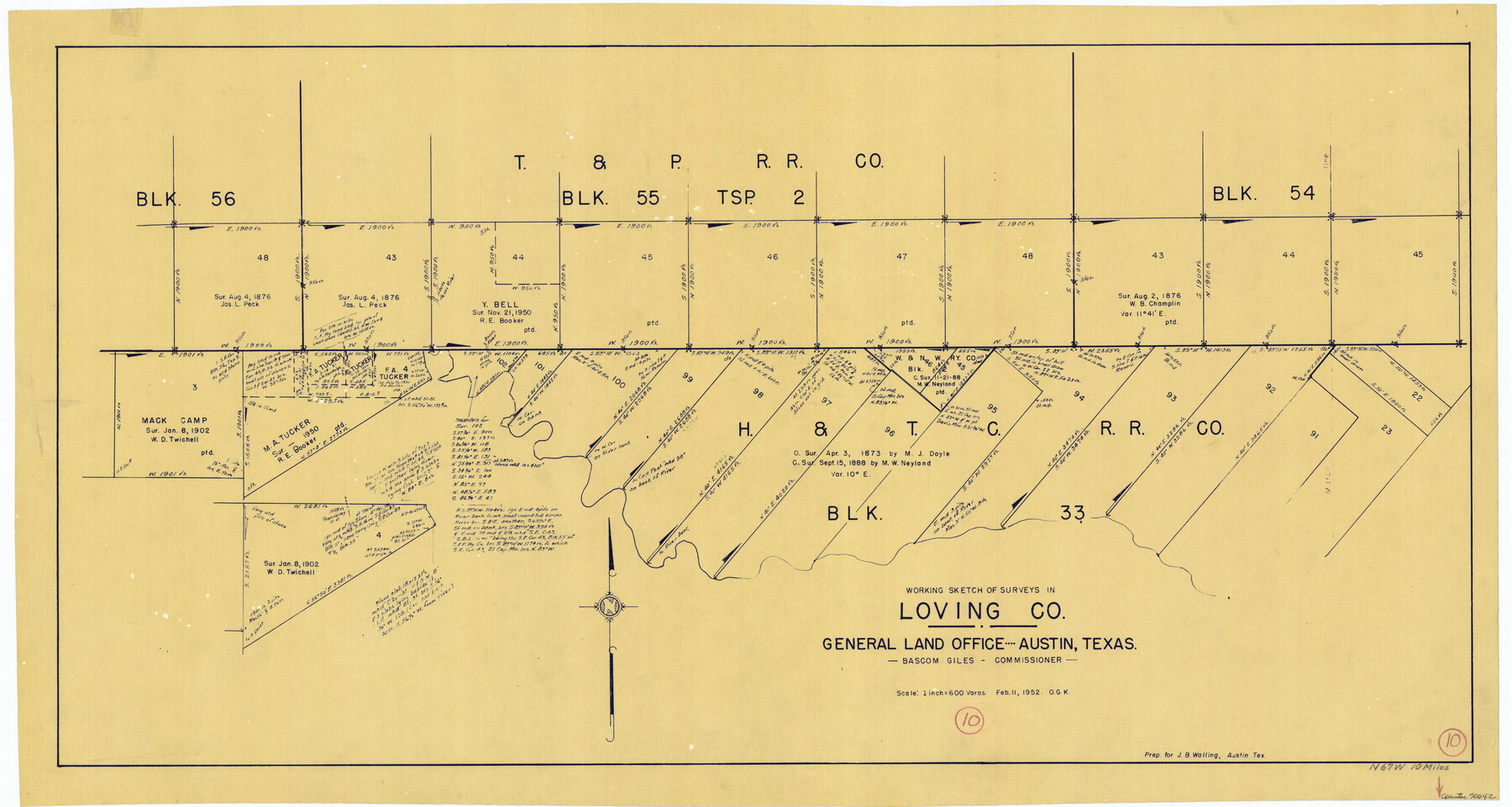
Loving County Working Sketch 10
-
Map/Doc
70642
-
Collection
General Map Collection
-
Object Dates
2/11/1952 (Creation Date)
-
People and Organizations
Otto G. Kurio (Draftsman)
-
Counties
Loving
-
Subjects
Surveying Working Sketch
-
Height x Width
20.0 x 37.4 inches
50.8 x 95.0 cm
-
Scale
1" = 600 varas
Part of: General Map Collection
Flight Mission No. CGI-3N, Frame 49, Cameron County

Print $20.00
- Digital $50.00
Flight Mission No. CGI-3N, Frame 49, Cameron County
1954
Size 18.8 x 22.4 inches
Map/Doc 84555
Flight Mission No. BRE-2P, Frame 130, Nueces County

Print $20.00
- Digital $50.00
Flight Mission No. BRE-2P, Frame 130, Nueces County
1956
Size 18.6 x 22.3 inches
Map/Doc 86803
Upton County Working Sketch 5

Print $20.00
- Digital $50.00
Upton County Working Sketch 5
1909
Size 15.9 x 27.1 inches
Map/Doc 69501
Gray County Working Sketch 4

Print $40.00
- Digital $50.00
Gray County Working Sketch 4
1958
Size 31.5 x 53.4 inches
Map/Doc 63235
Wilbarger Co.

Print $20.00
- Digital $50.00
Wilbarger Co.
1949
Size 46.8 x 38.1 inches
Map/Doc 77458
Travis County

Print $40.00
- Digital $50.00
Travis County
1936
Size 47.0 x 53.7 inches
Map/Doc 73305
Galveston County NRC Article 33.136 Sketch 13

Print $20.00
- Digital $50.00
Galveston County NRC Article 33.136 Sketch 13
2002
Size 17.9 x 22.4 inches
Map/Doc 77044
Nueces County Working Sketch 11

Print $20.00
- Digital $50.00
Nueces County Working Sketch 11
1965
Size 20.2 x 44.1 inches
Map/Doc 71313
Red River County Sketch File 10

Print $15.00
- Digital $50.00
Red River County Sketch File 10
1863
Size 9.1 x 7.4 inches
Map/Doc 35121

Uvalde County Sketch File 15

Print $6.00
- Digital $50.00
Uvalde County Sketch File 15
1849
Size 8.8 x 11.5 inches
Map/Doc 38985
Amistad International Reservoir on Rio Grande 110

Print $20.00
- Digital $50.00
Amistad International Reservoir on Rio Grande 110
1950
Size 41.4 x 29.5 inches
Map/Doc 75541
You may also like
Oldham County Rolled Sketch 5

Print $20.00
- Digital $50.00
Oldham County Rolled Sketch 5
1903
Size 29.7 x 36.6 inches
Map/Doc 9641
Wharton County Working Sketch 3

Print $20.00
- Digital $50.00
Wharton County Working Sketch 3
Size 17.5 x 16.4 inches
Map/Doc 72467
Delta County Sketch File 2

Print $4.00
- Digital $50.00
Delta County Sketch File 2
1871
Size 8.4 x 13.2 inches
Map/Doc 20670
Harris County Working Sketch 13

Print $20.00
- Digital $50.00
Harris County Working Sketch 13
1915
Size 19.9 x 11.0 inches
Map/Doc 65905
Pecos County Sketch File 53

Print $20.00
- Digital $50.00
Pecos County Sketch File 53
Size 18.0 x 38.9 inches
Map/Doc 10569
Cameron County Sketch File 17

Print $24.00
- Digital $50.00
Cameron County Sketch File 17
2009
Size 11.0 x 8.5 inches
Map/Doc 95191
[Sketch of J.D. Brown survey and vicinity]
![89964, [Sketch of J.D. Brown survey and vicinity], Twichell Survey Records](https://historictexasmaps.com/wmedia_w700/maps/89964-1.tif.jpg)
Print $40.00
- Digital $50.00
[Sketch of J.D. Brown survey and vicinity]
Size 44.1 x 62.7 inches
Map/Doc 89964
Ochiltree County Sketch File A

Print $22.00
- Digital $50.00
Ochiltree County Sketch File A
1888
Size 8.7 x 5.7 inches
Map/Doc 33167
[Part of Block GG]
![90314, [Part of Block GG], Twichell Survey Records](https://historictexasmaps.com/wmedia_w700/maps/90314-1.tif.jpg)
Print $20.00
- Digital $50.00
[Part of Block GG]
Size 15.2 x 21.5 inches
Map/Doc 90314
Glasscock County Working Sketch 16

Print $40.00
- Digital $50.00
Glasscock County Working Sketch 16
1984
Size 61.2 x 44.0 inches
Map/Doc 63189
Section P Tech Memorial Park, Inc.

Print $20.00
- Digital $50.00
Section P Tech Memorial Park, Inc.
1953
Size 21.1 x 32.3 inches
Map/Doc 92353
Childress County Rolled Sketch 5A

Print $20.00
- Digital $50.00
Childress County Rolled Sketch 5A
Size 32.9 x 21.9 inches
Map/Doc 5440