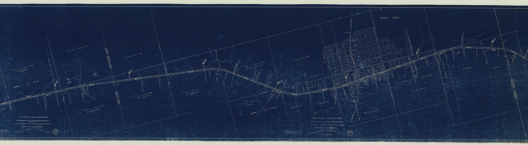
Right of Way and Track Map, The Wichita Falls & Southern Railway
Z-2-159
-
Map/Doc
64513
-
Collection
General Map Collection
-
Object Dates
1918/6/30
1942 (Creation Date)
-
Counties
Young Archer
-
Subjects
Railroads
-
Height x Width
25.5 x 92.5 inches
64.8 x 235.0 cm
-
Medium
blueprint/diazo
-
Scale
1 in. = 400 ft.
-
Comments
Operated by the Missouri, Kansas and Texas Railway of Texas. New Castle Branch, M.P. 834 to M.P. 8838, Station 2109+17 to Station 2320+37. Segment 2; see counter no. 64512 for segment 1.
-
Features
WF&S
Road to Seymour
Main Street
Grand Avenue
GT&W
Mud Creek
Road to Jacksboro
Part of: General Map Collection
Harris County Sketch File 59

Print $32.00
- Digital $50.00
Harris County Sketch File 59
1921
Size 14.3 x 9.0 inches
Map/Doc 25480
Zapata County Sketch File 8

Print $40.00
- Digital $50.00
Zapata County Sketch File 8
1917
Size 59.5 x 26.5 inches
Map/Doc 10438
Hartley County Working Sketch 5

Print $20.00
- Digital $50.00
Hartley County Working Sketch 5
1957
Size 46.3 x 28.9 inches
Map/Doc 66055
Tom Green County Working Sketch 8

Print $20.00
- Digital $50.00
Tom Green County Working Sketch 8
1950
Size 24.8 x 20.9 inches
Map/Doc 69377
[Three-Marine League line stipulation as determined by US Supreme Court, October 1968 term; corrections to stipulation; Texas GLO approximations of county areas embraced by county boundaries, shoreline and 3-marine league line and 3-mile line]

Print $64.00
[Three-Marine League line stipulation as determined by US Supreme Court, October 1968 term; corrections to stipulation; Texas GLO approximations of county areas embraced by county boundaries, shoreline and 3-marine league line and 3-mile line]
1962
Size 13.4 x 8.7 inches
Map/Doc 61371
Chambers County Sketch File 24

Print $20.00
- Digital $50.00
Chambers County Sketch File 24
1909
Size 34.1 x 14.5 inches
Map/Doc 11065
Pecos County Rolled Sketch 146C

Print $20.00
- Digital $50.00
Pecos County Rolled Sketch 146C
Size 43.1 x 39.5 inches
Map/Doc 9743
Sutton County Sketch File Ca

Print $6.00
- Digital $50.00
Sutton County Sketch File Ca
1901
Size 12.3 x 9.8 inches
Map/Doc 37382
State Mineral Subdivisions and Shoreline Meanders of Upper Trinity Bay and Trinity River Delta Area, Chambers County

Print $20.00
- Digital $50.00
State Mineral Subdivisions and Shoreline Meanders of Upper Trinity Bay and Trinity River Delta Area, Chambers County
1950
Size 42.8 x 44.7 inches
Map/Doc 1933
Pecos County Rolled Sketch 59

Print $20.00
- Digital $50.00
Pecos County Rolled Sketch 59
1922
Size 16.6 x 17.0 inches
Map/Doc 7231
Callahan County Working Sketch 2

Print $20.00
- Digital $50.00
Callahan County Working Sketch 2
1952
Size 29.1 x 35.4 inches
Map/Doc 67884
Flight Mission No. DIX-6P, Frame 191, Aransas County

Print $20.00
- Digital $50.00
Flight Mission No. DIX-6P, Frame 191, Aransas County
1956
Size 19.0 x 22.7 inches
Map/Doc 83853
You may also like
Pecos County Sketch File 39

Print $20.00
- Digital $50.00
Pecos County Sketch File 39
1898
Size 17.5 x 16.5 inches
Map/Doc 12177
Briscoe County

Print $20.00
- Digital $50.00
Briscoe County
1930
Size 42.5 x 35.8 inches
Map/Doc 77222
Irion County Sketch File 5

Print $16.00
- Digital $50.00
Irion County Sketch File 5
1900
Size 14.4 x 8.9 inches
Map/Doc 27463
El Paso County Rolled Sketch 52

Print $20.00
- Digital $50.00
El Paso County Rolled Sketch 52
1929
Size 18.6 x 24.5 inches
Map/Doc 5846
Uvalde County Working Sketch 44

Print $20.00
- Digital $50.00
Uvalde County Working Sketch 44
1978
Size 27.6 x 32.7 inches
Map/Doc 72114
Concho County Rolled Sketch 18

Print $20.00
- Digital $50.00
Concho County Rolled Sketch 18
1955
Size 11.4 x 18.3 inches
Map/Doc 5553
[Mrs. May Vinson Survey]
![91959, [Mrs. May Vinson Survey], Twichell Survey Records](https://historictexasmaps.com/wmedia_w700/maps/91959-1.tif.jpg)
Print $40.00
- Digital $50.00
[Mrs. May Vinson Survey]
Size 48.4 x 21.9 inches
Map/Doc 91959
Val Verde County Sketch File XXX1

Print $20.00
- Digital $50.00
Val Verde County Sketch File XXX1
Size 18.8 x 24.0 inches
Map/Doc 12547
Potter County Sketch File 20

Print $4.00
- Digital $50.00
Potter County Sketch File 20
Size 12.2 x 8.7 inches
Map/Doc 34411
Hays County Sketch File 8

Print $4.00
- Digital $50.00
Hays County Sketch File 8
1848
Size 5.5 x 7.8 inches
Map/Doc 26210
Ochiltree County Boundary File 2

Print $4.00
- Digital $50.00
Ochiltree County Boundary File 2
Size 7.7 x 8.6 inches
Map/Doc 57675
Township 2 South Range 11 West, South Western District, Louisiana

Print $20.00
- Digital $50.00
Township 2 South Range 11 West, South Western District, Louisiana
1882
Size 19.6 x 24.6 inches
Map/Doc 65881