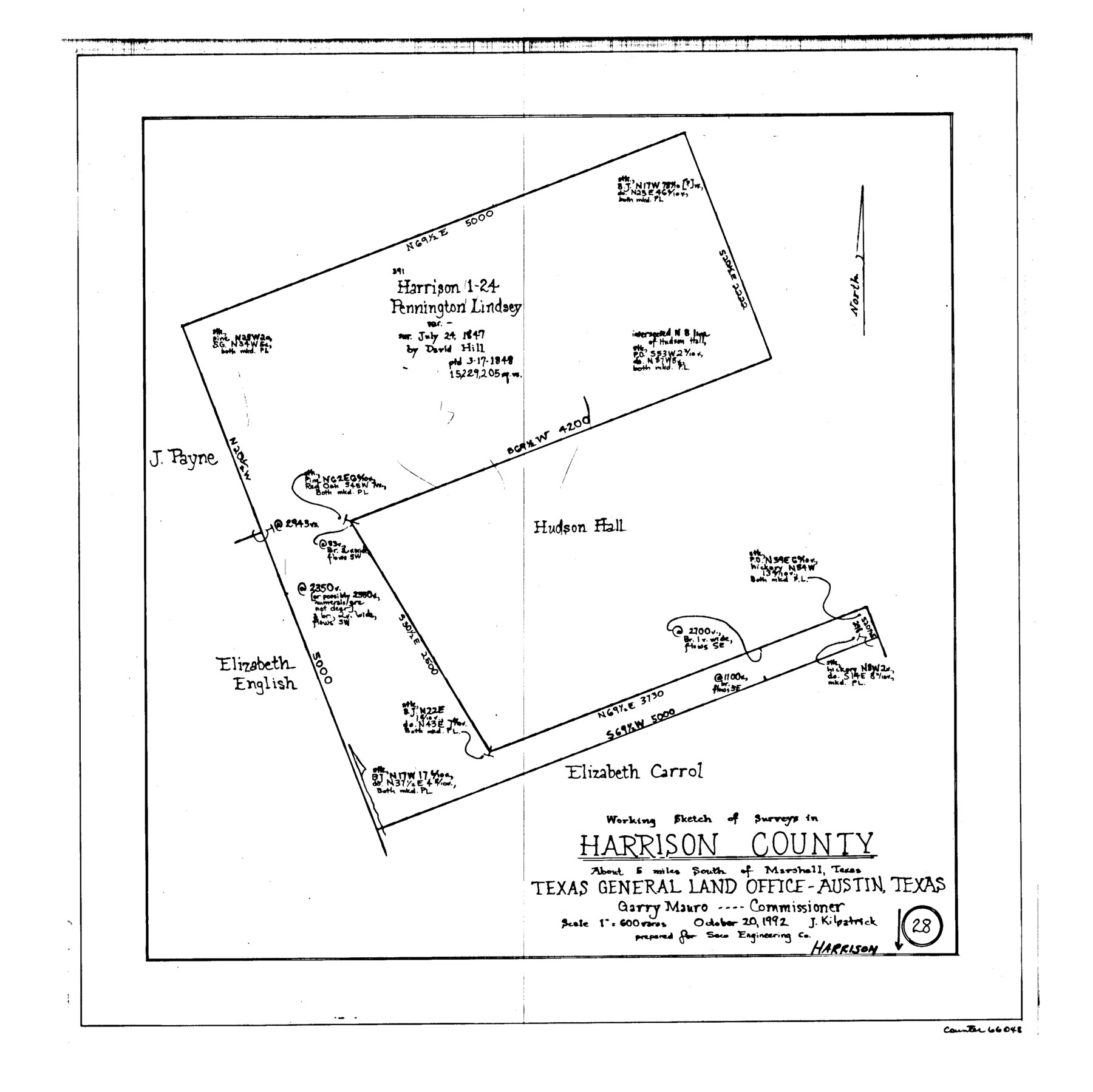
Harrison County Working Sketch 28
-
Map/Doc
66048
-
Collection
General Map Collection
-
Object Dates
10/20/1992 (Creation Date)
-
People and Organizations
Joan Kilpatrick (Draftsman)
-
Counties
Harrison
-
Subjects
Surveying Working Sketch
-
Height x Width
17.0 x 17.0 inches
43.2 x 43.2 cm
-
Scale
1" = 600 varas
Part of: General Map Collection
Flight Mission No. BQR-5K, Frame 65, Brazoria County

Print $20.00
- Digital $50.00
Flight Mission No. BQR-5K, Frame 65, Brazoria County
1952
Size 18.8 x 22.5 inches
Map/Doc 84010
Galveston County Rolled Sketch 34B

Print $20.00
- Digital $50.00
Galveston County Rolled Sketch 34B
1978
Size 28.4 x 40.0 inches
Map/Doc 5968
Grayson County

Print $20.00
- Digital $50.00
Grayson County
1935
Size 43.3 x 39.9 inches
Map/Doc 77294
Flight Mission No. CGI-3N, Frame 133, Cameron County

Print $20.00
- Digital $50.00
Flight Mission No. CGI-3N, Frame 133, Cameron County
1954
Size 18.5 x 22.1 inches
Map/Doc 84606
Houston County Working Sketch 2

Print $20.00
- Digital $50.00
Houston County Working Sketch 2
Size 16.1 x 18.6 inches
Map/Doc 66232
Howard County

Print $20.00
- Digital $50.00
Howard County
1922
Size 40.3 x 34.6 inches
Map/Doc 77318
Victoria County Working Sketch 1

Print $20.00
- Digital $50.00
Victoria County Working Sketch 1
1938
Size 33.5 x 36.9 inches
Map/Doc 72271
Nueces County Rolled Sketch 96

Print $44.00
Nueces County Rolled Sketch 96
1983
Size 24.2 x 36.5 inches
Map/Doc 7053
Burleson County Sketch File 5

Print $4.00
- Digital $50.00
Burleson County Sketch File 5
Size 12.9 x 8.3 inches
Map/Doc 16649
Travis County Sketch File 67

Print $10.00
- Digital $50.00
Travis County Sketch File 67
1951
Size 14.3 x 9.0 inches
Map/Doc 38446
Presidio County Working Sketch 33

Print $40.00
- Digital $50.00
Presidio County Working Sketch 33
1947
Size 41.6 x 50.6 inches
Map/Doc 71710
Andrews County Sketch File 12

Print $8.00
- Digital $50.00
Andrews County Sketch File 12
1963
Size 11.1 x 8.5 inches
Map/Doc 12857
You may also like
United States - Gulf Coast - From Latitude 26° 33' to the Rio Grande Texas

Print $20.00
- Digital $50.00
United States - Gulf Coast - From Latitude 26° 33' to the Rio Grande Texas
1918
Size 27.7 x 18.2 inches
Map/Doc 72850
[Galveston, Harrisburg & San Antonio Railroad from Cuero to Stockdale]
![64202, [Galveston, Harrisburg & San Antonio Railroad from Cuero to Stockdale], General Map Collection](https://historictexasmaps.com/wmedia_w700/maps/64202.tif.jpg)
Print $20.00
- Digital $50.00
[Galveston, Harrisburg & San Antonio Railroad from Cuero to Stockdale]
1907
Size 13.3 x 33.1 inches
Map/Doc 64202
Texas State Boundary Line 8

Print $170.00
Texas State Boundary Line 8
2000
Size 11.3 x 8.8 inches
Map/Doc 75054
San Jacinto County Sketch File 16

Print $4.00
San Jacinto County Sketch File 16
1934
Size 11.3 x 8.7 inches
Map/Doc 35729
Hopkins County Sketch File 28

Print $20.00
- Digital $50.00
Hopkins County Sketch File 28
Size 24.8 x 34.0 inches
Map/Doc 11786
Pecos County Rolled Sketch 190

Print $20.00
- Digital $50.00
Pecos County Rolled Sketch 190
2005
Size 20.3 x 26.1 inches
Map/Doc 83284
Presidio County Sketch File 105

Print $20.00
- Digital $50.00
Presidio County Sketch File 105
Size 13.1 x 20.6 inches
Map/Doc 82962
Limestone County Rolled Sketch 3

Print $20.00
- Digital $50.00
Limestone County Rolled Sketch 3
Size 24.3 x 23.6 inches
Map/Doc 6627
Dimmit County Working Sketch 20

Print $20.00
- Digital $50.00
Dimmit County Working Sketch 20
1948
Size 30.4 x 21.3 inches
Map/Doc 68681
Taylor County Sketch File 5

Print $4.00
- Digital $50.00
Taylor County Sketch File 5
Size 9.3 x 7.8 inches
Map/Doc 37781
Brewster County Sketch File A-1

Print $8.00
- Digital $50.00
Brewster County Sketch File A-1
1911
Size 14.2 x 8.7 inches
Map/Doc 15712
Flight Mission No. BRA-9M, Frame 77, Jefferson County

Print $20.00
- Digital $50.00
Flight Mission No. BRA-9M, Frame 77, Jefferson County
1953
Size 18.5 x 22.4 inches
Map/Doc 85660