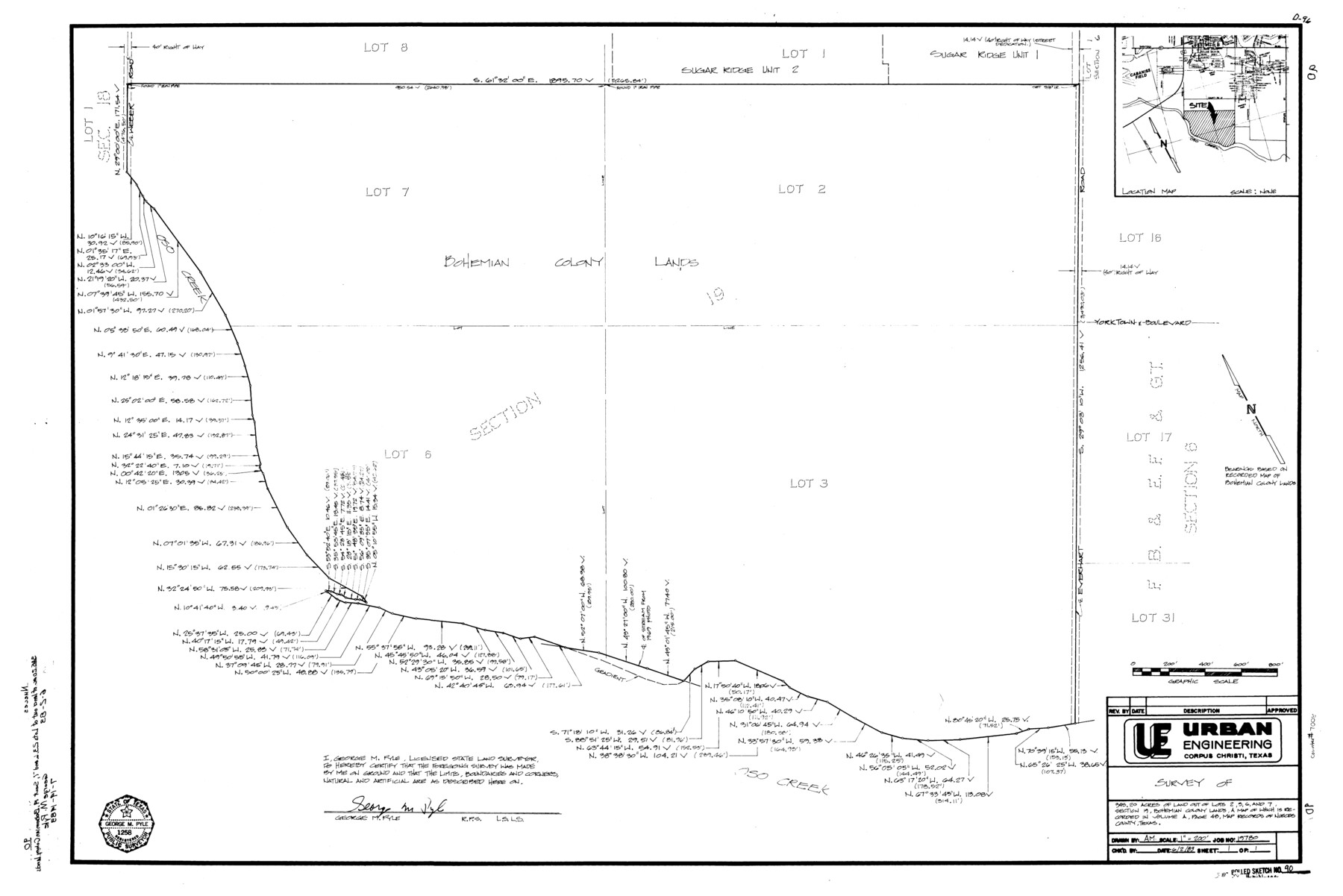
Nueces County Rolled Sketch 90
[Sketch, report, and exhibits relating to a shoreline survey of 345.20 acres of land out of Lots 2, 3, 6, and 7, Section 19, Bohemian Colony Lands]
-
Map/Doc
7008
-
Collection
General Map Collection
-
Object Dates
1983 (Creation Date)
7/19/1983 (File Date)
-
People and Organizations
George M. Pyle (Surveyor/Engineer)
-
Counties
Nueces
-
Subjects
Surveying Rolled Sketch
-
Height x Width
24.8 x 37.1 inches
63.0 x 94.2 cm
Part of: General Map Collection
San Jacinto River, Buff Lake Sheet 1/Caney Creek

Print $20.00
- Digital $50.00
San Jacinto River, Buff Lake Sheet 1/Caney Creek
1937
Size 18.7 x 37.6 inches
Map/Doc 65147
Amistad International Reservoir on Rio Grande 77

Print $20.00
- Digital $50.00
Amistad International Reservoir on Rio Grande 77
1949
Size 28.5 x 40.2 inches
Map/Doc 75505
Wichita County Sketch File 9

Print $4.00
- Digital $50.00
Wichita County Sketch File 9
1878
Size 12.8 x 8.2 inches
Map/Doc 40050
Reagan County Rolled Sketch 22

Print $20.00
- Digital $50.00
Reagan County Rolled Sketch 22
Size 33.9 x 33.1 inches
Map/Doc 9817
Dallas County Working Sketch 4

Print $20.00
- Digital $50.00
Dallas County Working Sketch 4
1935
Size 24.1 x 30.4 inches
Map/Doc 68570
Menard County Sketch File 13

Print $4.00
- Digital $50.00
Menard County Sketch File 13
1892
Size 12.8 x 8.2 inches
Map/Doc 31506
Briscoe County Sketch File 6

Print $40.00
- Digital $50.00
Briscoe County Sketch File 6
Size 29.8 x 24.6 inches
Map/Doc 10995
Map of Galveston County

Print $20.00
- Digital $50.00
Map of Galveston County
1864
Size 19.6 x 28.0 inches
Map/Doc 3576
Williamson County Sketch File 13a

Print $4.00
- Digital $50.00
Williamson County Sketch File 13a
1871
Size 8.1 x 13.6 inches
Map/Doc 40330
Uvalde County Working Sketch 46

Print $20.00
- Digital $50.00
Uvalde County Working Sketch 46
1979
Size 37.1 x 26.3 inches
Map/Doc 72116
Polk County Rolled Sketch 32

Print $20.00
- Digital $50.00
Polk County Rolled Sketch 32
Size 21.6 x 15.8 inches
Map/Doc 7318
Flight Mission No. CLL-3N, Frame 15, Willacy County

Print $20.00
- Digital $50.00
Flight Mission No. CLL-3N, Frame 15, Willacy County
1950
Size 18.4 x 22.0 inches
Map/Doc 87081
You may also like
Outer Continental Shelf Leasing Maps (Louisiana Offshore Operations)

Print $20.00
- Digital $50.00
Outer Continental Shelf Leasing Maps (Louisiana Offshore Operations)
1954
Size 25.5 x 15.3 inches
Map/Doc 76093
[Stone, Kyle and Kyle Block M6]
![90414, [Stone, Kyle and Kyle Block M6], Twichell Survey Records](https://historictexasmaps.com/wmedia_w700/maps/90414-1.tif.jpg)
Print $20.00
- Digital $50.00
[Stone, Kyle and Kyle Block M6]
1908
Size 18.6 x 25.5 inches
Map/Doc 90414
Carte Reduite du Globe Terrestre

Print $20.00
- Digital $50.00
Carte Reduite du Globe Terrestre
1782
Size 13.5 x 17.1 inches
Map/Doc 97117
Flight Mission No. DCL-6C, Frame 76, Kenedy County

Print $20.00
- Digital $50.00
Flight Mission No. DCL-6C, Frame 76, Kenedy County
1943
Size 18.6 x 22.3 inches
Map/Doc 85918
Flight Mission No. DQN-3K, Frame 50, Calhoun County

Print $20.00
- Digital $50.00
Flight Mission No. DQN-3K, Frame 50, Calhoun County
1953
Size 18.4 x 22.2 inches
Map/Doc 84351
Nueces County Rolled Sketch 128 A-E

Print $10.00
- Digital $50.00
Nueces County Rolled Sketch 128 A-E
1998
Size 11.0 x 8.5 inches
Map/Doc 41611
Milam County Working Sketch 1

Print $20.00
- Digital $50.00
Milam County Working Sketch 1
1915
Size 16.3 x 14.2 inches
Map/Doc 71016
Wise County Rolled Sketch 4

Print $20.00
- Digital $50.00
Wise County Rolled Sketch 4
1955
Size 20.0 x 13.7 inches
Map/Doc 8278
Frio County Sketch File 4

Print $4.00
- Digital $50.00
Frio County Sketch File 4
1877
Size 8.0 x 9.6 inches
Map/Doc 23111
Flight Mission No. CGI-4N, Frame 175, Cameron County

Print $20.00
- Digital $50.00
Flight Mission No. CGI-4N, Frame 175, Cameron County
1955
Size 18.6 x 22.4 inches
Map/Doc 84678
Sutton County Working Sketch 49

Print $20.00
- Digital $50.00
Sutton County Working Sketch 49
1955
Size 43.3 x 19.5 inches
Map/Doc 62392
Wendlandt's Subdivision of part of Outlot 4, Division "Z"

Print $20.00
- Digital $50.00
Wendlandt's Subdivision of part of Outlot 4, Division "Z"
1910
Size 18.0 x 13.6 inches
Map/Doc 83428