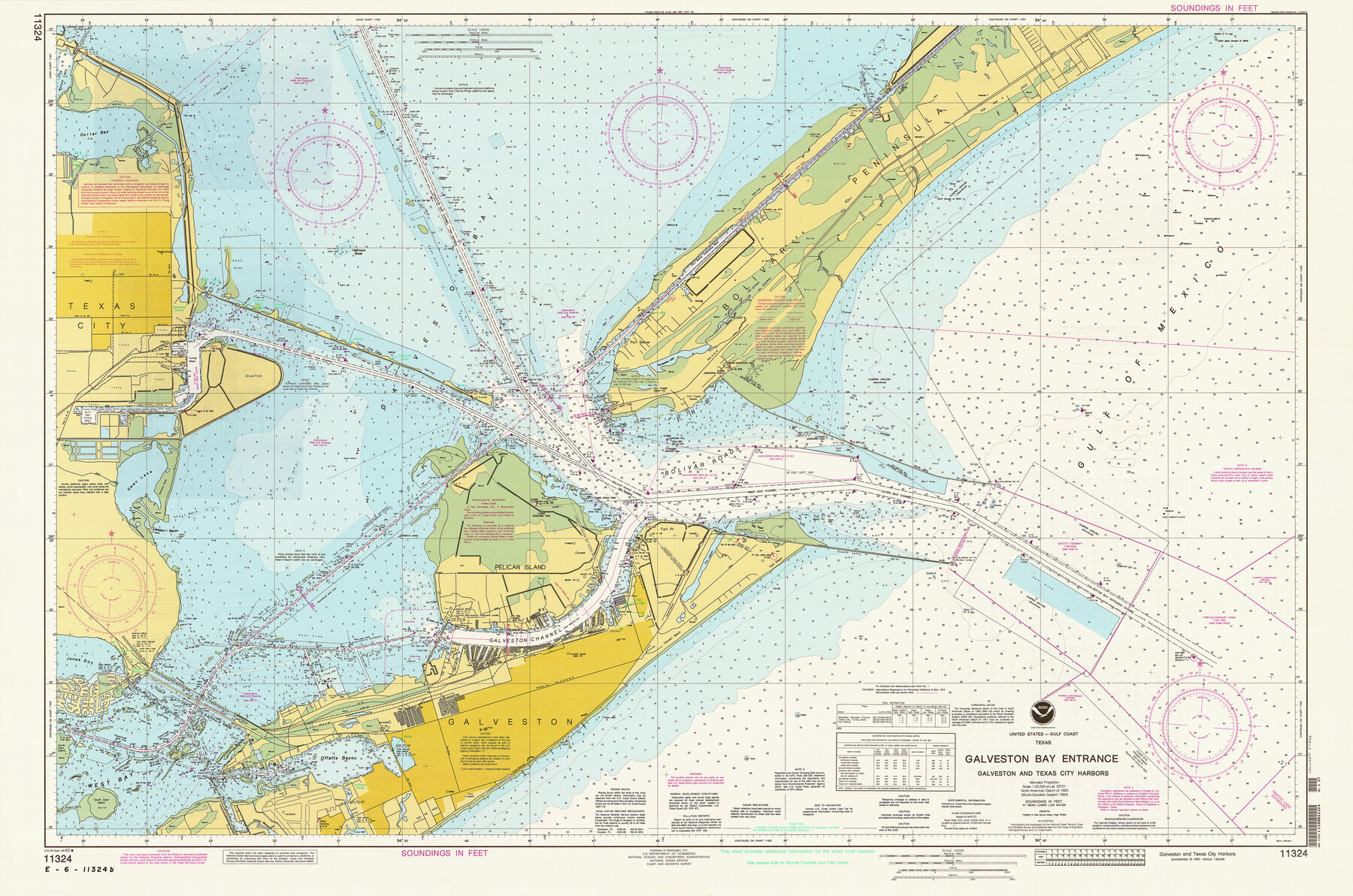
Galveston Bay Entrance - Galveston and Texas City Harbors
E-6-11324b
-
Map/Doc
69866
-
Collection
General Map Collection
-
Object Dates
9/26/1992 (Creation Date)
-
Counties
Galveston
-
Subjects
Nautical Charts
-
Height x Width
37.1 x 55.6 inches
94.2 x 141.2 cm
-
Comments
dual-sided map
Part of: General Map Collection
Medina County Rolled Sketch 9

Print $20.00
- Digital $50.00
Medina County Rolled Sketch 9
Size 18.8 x 31.0 inches
Map/Doc 6743
Flight Mission No. DCL-4C, Frame 145, Kenedy County

Print $20.00
- Digital $50.00
Flight Mission No. DCL-4C, Frame 145, Kenedy County
1943
Size 18.6 x 22.4 inches
Map/Doc 85823

Collingsworth County Sketch File 11

Print $32.00
- Digital $50.00
Collingsworth County Sketch File 11
1991
Size 11.2 x 8.6 inches
Map/Doc 18893
Cooke County Sketch File 34

Print $44.00
- Digital $50.00
Cooke County Sketch File 34
Size 11.8 x 8.2 inches
Map/Doc 19298
Liberty County Working Sketch 10

Print $40.00
- Digital $50.00
Liberty County Working Sketch 10
1909
Size 38.9 x 48.3 inches
Map/Doc 70469
Wise County Working Sketch 24

Print $40.00
- Digital $50.00
Wise County Working Sketch 24
1983
Size 37.1 x 58.2 inches
Map/Doc 72638
Connected Map of Austin's Colony

Print $40.00
- Digital $50.00
Connected Map of Austin's Colony
1837
Size 93.2 x 43.7 inches
Map/Doc 93377
Reagan County Sketch File 12

Print $20.00
- Digital $50.00
Reagan County Sketch File 12
1928
Size 23.2 x 18.3 inches
Map/Doc 12218
Hemphill County Rolled Sketch 17

Print $20.00
- Digital $50.00
Hemphill County Rolled Sketch 17
1965
Size 29.2 x 40.1 inches
Map/Doc 6198
Brewster County Working Sketch 10

Print $20.00
- Digital $50.00
Brewster County Working Sketch 10
1910
Size 17.8 x 16.8 inches
Map/Doc 67543
Palo Pinto County Rolled Sketch 6

Print $40.00
- Digital $50.00
Palo Pinto County Rolled Sketch 6
1917
Size 64.4 x 35.4 inches
Map/Doc 9673
You may also like
[Surveys covering parts of Blocks 5T, R2, M24, M23]
![92122, [Surveys covering parts of Blocks 5T, R2, M24, M23], Twichell Survey Records](https://historictexasmaps.com/wmedia_w700/maps/92122-1.tif.jpg)
Print $20.00
- Digital $50.00
[Surveys covering parts of Blocks 5T, R2, M24, M23]
Size 15.0 x 19.0 inches
Map/Doc 92122
The MKT - Texas Empire of the South

Print $20.00
- Digital $50.00
The MKT - Texas Empire of the South
1905
Size 18.5 x 40.6 inches
Map/Doc 97035
Eastland County Working Sketch 42

Print $20.00
- Digital $50.00
Eastland County Working Sketch 42
1979
Size 43.5 x 35.0 inches
Map/Doc 68823
McLennan County Boundary File 7

Print $8.00
- Digital $50.00
McLennan County Boundary File 7
Size 14.1 x 8.6 inches
Map/Doc 57005
Crockett County Sketch File 63

Print $4.00
- Digital $50.00
Crockett County Sketch File 63
1927
Size 11.0 x 8.8 inches
Map/Doc 19851
Sketch of Sabine Lake and Pass

Print $20.00
- Digital $50.00
Sketch of Sabine Lake and Pass
1840
Size 24.8 x 18.2 inches
Map/Doc 72725

Val Verde County Working Sketch 59

Print $20.00
- Digital $50.00
Val Verde County Working Sketch 59
1958
Size 38.6 x 35.0 inches
Map/Doc 72194
Upton County Rolled Sketch 29

Print $20.00
- Digital $50.00
Upton County Rolled Sketch 29
1947
Size 32.0 x 45.3 inches
Map/Doc 10736
Brazos River Conservation and Reclamation District Official Boundary Line Survey

Print $20.00
- Digital $50.00
Brazos River Conservation and Reclamation District Official Boundary Line Survey
Size 36.9 x 25.0 inches
Map/Doc 90251
Map of Taylor, Bastrop & Houston Railroad in Williamson, Travis, & Bastrop Counties, Texas

Print $20.00
- Digital $50.00
Map of Taylor, Bastrop & Houston Railroad in Williamson, Travis, & Bastrop Counties, Texas
1887
Size 26.3 x 17.8 inches
Map/Doc 65468
Cass County Working Sketch 9

Print $20.00
- Digital $50.00
Cass County Working Sketch 9
1937
Size 28.4 x 32.7 inches
Map/Doc 67912