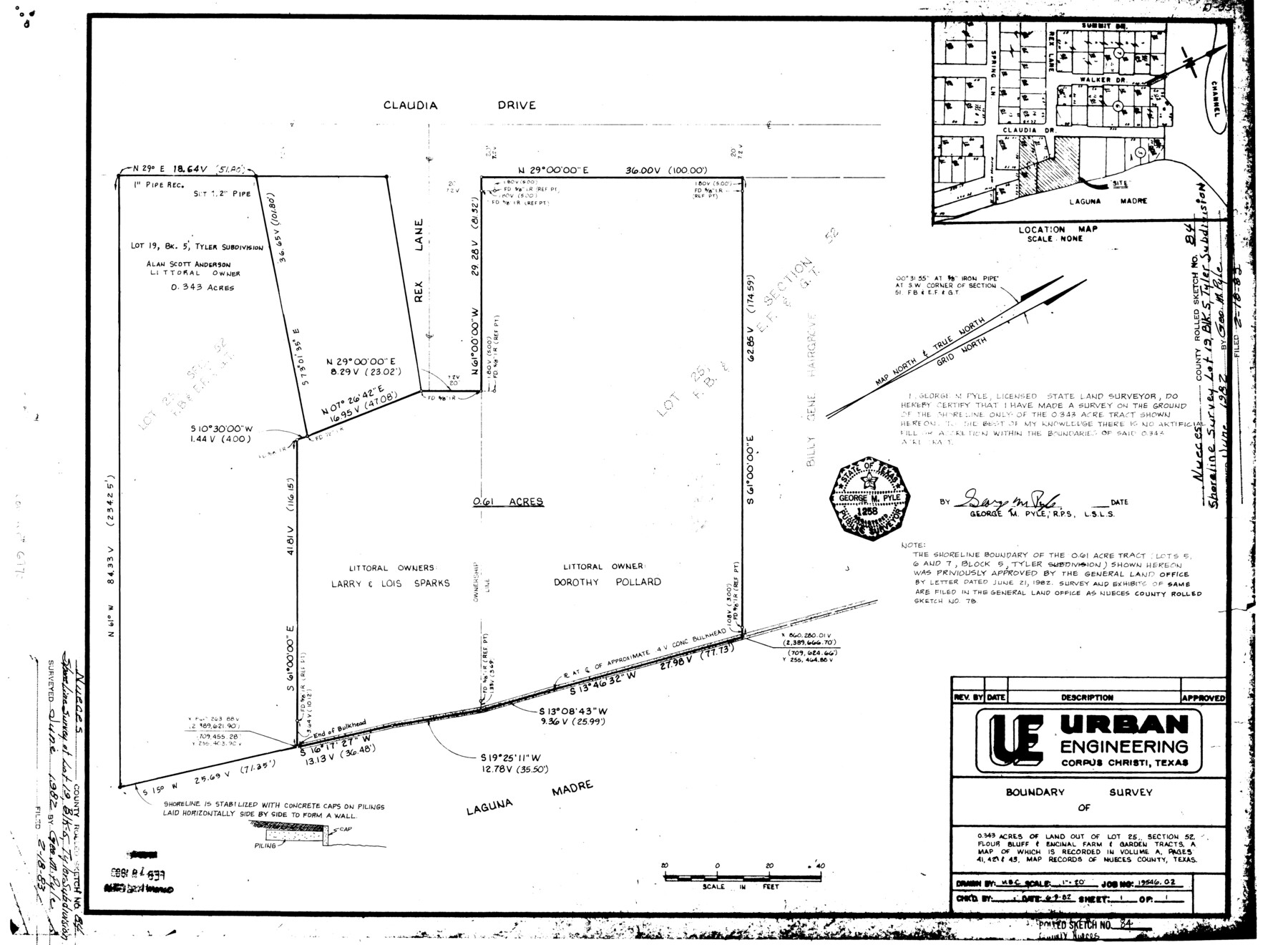
Nueces County Rolled Sketch 84
Boundary survey of 0.343 acres of land out of lot 25, section 52, Flour Bluff & Encinal Farm & Garden Tracts
-
Map/Doc
6970
-
Collection
General Map Collection
-
Object Dates
1982/6/9 (Creation Date)
1983/2/18 (File Date)
-
People and Organizations
George M. Pyle (Surveyor/Engineer)
-
Counties
Nueces
-
Subjects
Surveying Rolled Sketch
-
Height x Width
18.1 x 24.7 inches
46.0 x 62.7 cm
-
Medium
mylar, print
-
Scale
1" = 20 feet
Part of: General Map Collection
Brewster County Working Sketch 38

Print $20.00
- Digital $50.00
Brewster County Working Sketch 38
1944
Size 36.3 x 28.4 inches
Map/Doc 67572
Crockett County Sketch File 86

Print $4.00
- Digital $50.00
Crockett County Sketch File 86
1939
Size 11.5 x 9.1 inches
Map/Doc 19908
Wise County Sketch File 27

Print $4.00
- Digital $50.00
Wise County Sketch File 27
1857
Size 12.4 x 8.2 inches
Map/Doc 40576
A New Map of the Whole Continent of America. Divided into North and South and West Indies, wherein are exactly decribed the United States of North America as well as the Several European Possessions according to the Preliminaries of Peace…

Print $40.00
- Digital $50.00
A New Map of the Whole Continent of America. Divided into North and South and West Indies, wherein are exactly decribed the United States of North America as well as the Several European Possessions according to the Preliminaries of Peace…
Size 22.0 x 48.3 inches
Map/Doc 95135
Jack County Boundary File 1

Print $26.00
- Digital $50.00
Jack County Boundary File 1
Size 12.9 x 8.2 inches
Map/Doc 55363
Pecos County Working Sketch 42

Print $20.00
- Digital $50.00
Pecos County Working Sketch 42
1942
Size 31.3 x 23.9 inches
Map/Doc 71514
Brazos Santiago

Print $20.00
- Digital $50.00
Brazos Santiago
1884
Size 24.4 x 18.2 inches
Map/Doc 73030
Harris County Rolled Sketch WDC

Print $40.00
- Digital $50.00
Harris County Rolled Sketch WDC
1936
Size 42.7 x 68.4 inches
Map/Doc 9126
[Sketch for Mineral Application 1487 -Big Wichita River, Ernest R. Smith]
![65684, [Sketch for Mineral Application 1487 -Big Wichita River, Ernest R. Smith], General Map Collection](https://historictexasmaps.com/wmedia_w700/maps/65684.tif.jpg)
Print $40.00
- Digital $50.00
[Sketch for Mineral Application 1487 -Big Wichita River, Ernest R. Smith]
1918
Size 32.2 x 130.1 inches
Map/Doc 65684
Trinity County Working Sketch 7a

Print $20.00
- Digital $50.00
Trinity County Working Sketch 7a
1933
Size 39.7 x 27.3 inches
Map/Doc 69455
Hardin County Sketch File 12a

Print $4.00
- Digital $50.00
Hardin County Sketch File 12a
1866
Size 6.6 x 7.4 inches
Map/Doc 25118
Cooke County Working Sketch 24

Print $20.00
- Digital $50.00
Cooke County Working Sketch 24
1972
Size 22.1 x 24.4 inches
Map/Doc 68261
You may also like

Flight Mission No. BRA-3M, Frame 190, Jefferson County

Print $20.00
- Digital $50.00
Flight Mission No. BRA-3M, Frame 190, Jefferson County
1953
Size 18.6 x 22.3 inches
Map/Doc 85405
Map of Haskell County

Print $20.00
- Digital $50.00
Map of Haskell County
1899
Size 39.8 x 35.7 inches
Map/Doc 4974
Presidio County Sketch File 100

Print $4.00
- Digital $50.00
Presidio County Sketch File 100
1963
Size 11.2 x 8.9 inches
Map/Doc 34791
Dimmit County Working Sketch 42

Print $20.00
- Digital $50.00
Dimmit County Working Sketch 42
1977
Size 33.5 x 39.6 inches
Map/Doc 68703
Presidio County Working Sketch 41

Print $20.00
- Digital $50.00
Presidio County Working Sketch 41
1948
Size 20.3 x 14.4 inches
Map/Doc 71718
Presidio County Working Sketch 91

Print $40.00
- Digital $50.00
Presidio County Working Sketch 91
1974
Size 42.0 x 59.4 inches
Map/Doc 71768
El Paso County Working Sketch 4

Print $20.00
- Digital $50.00
El Paso County Working Sketch 4
1916
Size 21.4 x 37.3 inches
Map/Doc 69026
Bell County Sketch File 18

Print $4.00
- Digital $50.00
Bell County Sketch File 18
1870
Size 7.9 x 9.0 inches
Map/Doc 14400
Panola County Working Sketch 29

Print $20.00
- Digital $50.00
Panola County Working Sketch 29
1980
Map/Doc 71438
Aransas County Sketch File 6

Print $4.00
- Digital $50.00
Aransas County Sketch File 6
Size 8.2 x 10.7 inches
Map/Doc 13110
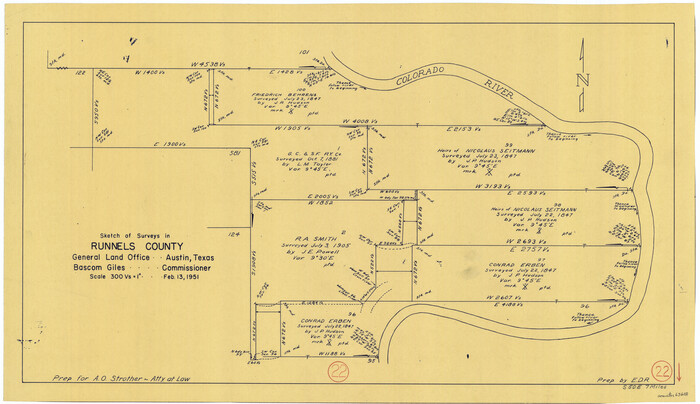
Runnels County Working Sketch 22
Print $20.00
- Digital $50.00
Runnels County Working Sketch 22
1951
Size 16.2 x 28.1 inches
Map/Doc 63618