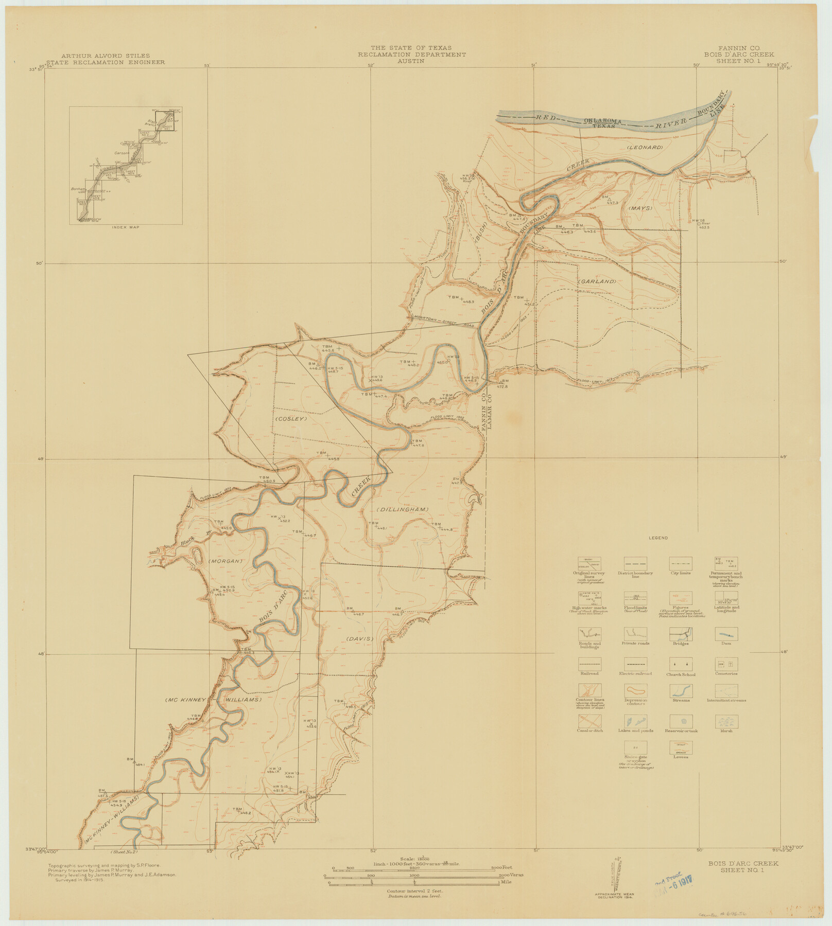
Red River, Bois D'Arc Creek Floodway Sheet No. 1
-
Map/Doc
69656
-
Collection
General Map Collection
-
Object Dates
1915 (Creation Date)
-
People and Organizations
Texas State Reclamation Department (Publisher)
S.P. Floore (Surveyor/Engineer)
-
Counties
Fannin
-
Subjects
River Surveys Topographic
-
Height x Width
28.8 x 25.9 inches
73.2 x 65.8 cm
Part of: General Map Collection
Flight Mission No. CLL-4N, Frame 34, Willacy County

Print $20.00
- Digital $50.00
Flight Mission No. CLL-4N, Frame 34, Willacy County
1954
Size 18.4 x 22.2 inches
Map/Doc 87107
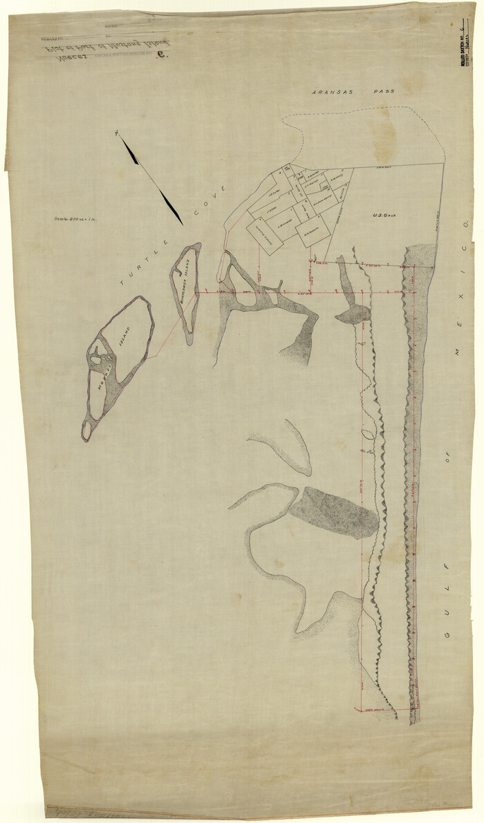
Calhoun County NRC Article 33.136 Sketch 1

Print $42.00
- Digital $50.00
Calhoun County NRC Article 33.136 Sketch 1
2000
Size 16.8 x 21.7 inches
Map/Doc 61556
Zapata County Rolled Sketch 15

Print $20.00
- Digital $50.00
Zapata County Rolled Sketch 15
1925
Size 14.6 x 16.4 inches
Map/Doc 8313
[Surveys in the Bexar District along the Pedernales River]
![177, [Surveys in the Bexar District along the Pedernales River], General Map Collection](https://historictexasmaps.com/wmedia_w700/maps/177.tif.jpg)
Print $20.00
- Digital $50.00
[Surveys in the Bexar District along the Pedernales River]
1845
Size 18.7 x 11.0 inches
Map/Doc 177
McMullen County Working Sketch 33

Print $20.00
- Digital $50.00
McMullen County Working Sketch 33
1959
Size 37.3 x 27.0 inches
Map/Doc 70734
Bailey County

Print $20.00
- Digital $50.00
Bailey County
1956
Size 47.0 x 30.0 inches
Map/Doc 77206
San Augustine County Sketch File 18

Print $6.00
San Augustine County Sketch File 18
Size 14.4 x 8.9 inches
Map/Doc 35675
Nueces County Rolled Sketch 6
Print $20.00
- Digital $50.00
Nueces County Rolled Sketch 6
Size 37.8 x 22.2 inches
Map/Doc 6867
Flight Mission No. DQN-6K, Frame 74, Calhoun County

Print $20.00
- Digital $50.00
Flight Mission No. DQN-6K, Frame 74, Calhoun County
1953
Size 18.5 x 22.2 inches
Map/Doc 84446
Harris County Sketch File F

Print $4.00
- Digital $50.00
Harris County Sketch File F
1860
Size 10.1 x 5.1 inches
Map/Doc 25317
Flight Mission No. BRA-16M, Frame 53, Jefferson County

Print $20.00
- Digital $50.00
Flight Mission No. BRA-16M, Frame 53, Jefferson County
1953
Size 18.4 x 22.6 inches
Map/Doc 85670
Nueces County Rolled Sketch 109

Print $20.00
- Digital $50.00
Nueces County Rolled Sketch 109
1989
Size 18.8 x 25.0 inches
Map/Doc 7116
You may also like
Sterling County Rolled Sketch 35

Print $20.00
- Digital $50.00
Sterling County Rolled Sketch 35
1960
Size 20.8 x 21.8 inches
Map/Doc 7859
Upton County Rolled Sketch 59

Print $40.00
- Digital $50.00
Upton County Rolled Sketch 59
1994
Size 35.8 x 49.2 inches
Map/Doc 10637
Bailey County Working Sketch 2

Print $20.00
- Digital $50.00
Bailey County Working Sketch 2
1920
Size 17.8 x 16.2 inches
Map/Doc 67589
Mason County Rolled Sketch 1

Print $20.00
- Digital $50.00
Mason County Rolled Sketch 1
1939
Size 38.3 x 26.8 inches
Map/Doc 6672
Hockley County

Print $20.00
- Digital $50.00
Hockley County
1900
Size 27.0 x 20.7 inches
Map/Doc 6215
Red River County Sketch File 11

Print $4.00
- Digital $50.00
Red River County Sketch File 11
Size 11.8 x 8.1 inches
Map/Doc 35127
Spanish Province of Texas compiled from map on file among archives at Saltillo

Print $20.00
- Digital $50.00
Spanish Province of Texas compiled from map on file among archives at Saltillo
1897
Size 13.6 x 16.0 inches
Map/Doc 93412
Flight Mission No. BQY-4M, Frame 66, Harris County

Print $20.00
- Digital $50.00
Flight Mission No. BQY-4M, Frame 66, Harris County
1953
Size 18.4 x 22.3 inches
Map/Doc 85275
Swisher County

Print $20.00
- Digital $50.00
Swisher County
1900
Size 45.5 x 39.0 inches
Map/Doc 63053
Nueces County Rolled Sketch 100

Print $20.00
- Digital $50.00
Nueces County Rolled Sketch 100
1938
Size 30.4 x 30.4 inches
Map/Doc 10210
Hamilton County Working Sketch 16

Print $40.00
- Digital $50.00
Hamilton County Working Sketch 16
1950
Size 48.0 x 40.6 inches
Map/Doc 63354
Mitchell County Working Sketch 9

Print $20.00
- Digital $50.00
Mitchell County Working Sketch 9
1987
Size 25.8 x 41.1 inches
Map/Doc 71066