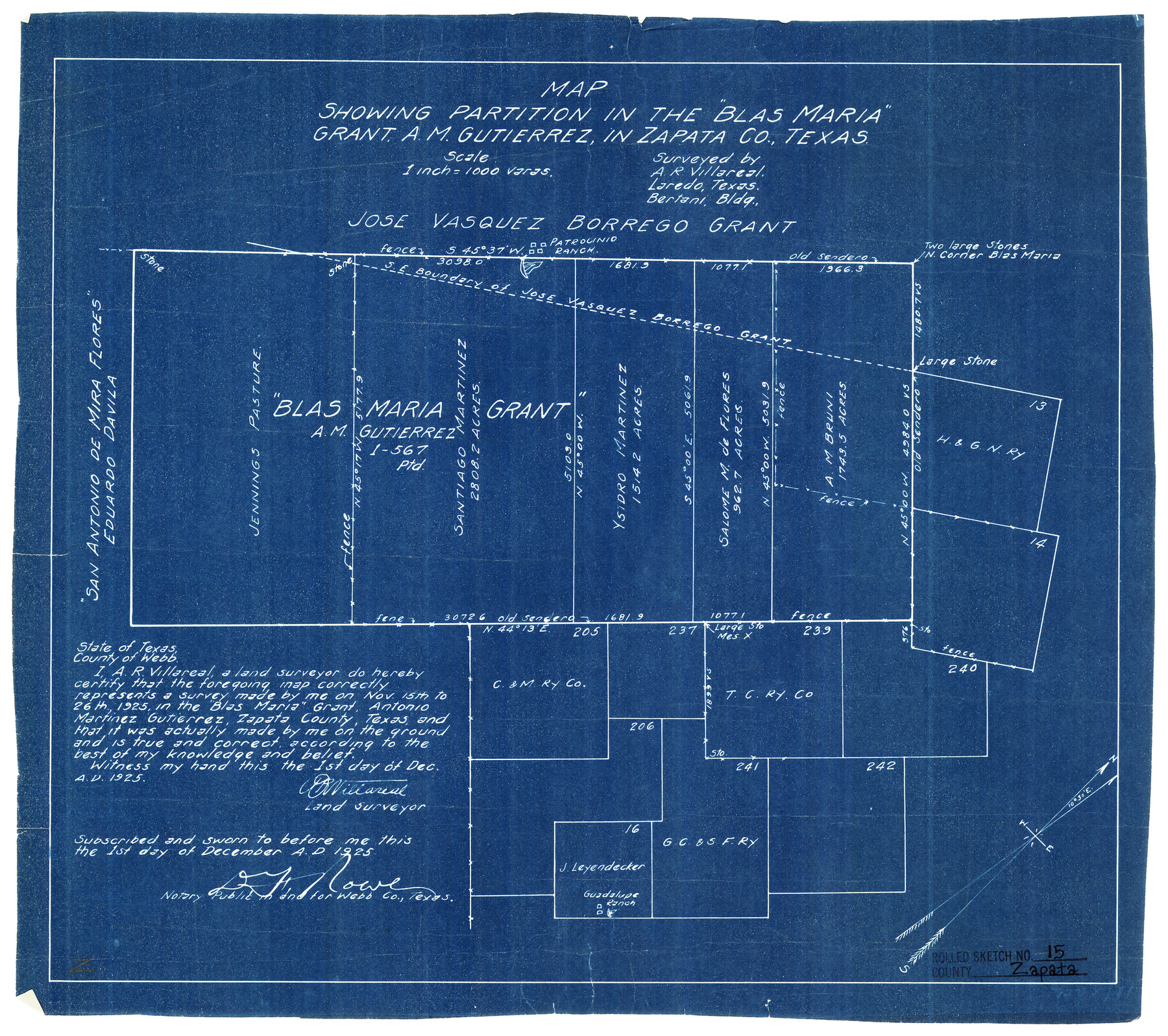
Zapata County Rolled Sketch 15
Map showing partition in the "Blas Maria" grant, A.M. Gutierrez, in Zapata Co., Texas
-
Map/Doc
8313
-
Collection
General Map Collection
-
Object Dates
12/1/1925 (Creation Date)
-
People and Organizations
A.R. Villareal (Surveyor/Engineer)
-
Counties
Zapata
-
Subjects
Surveying Rolled Sketch
-
Height x Width
14.6 x 16.4 inches
37.1 x 41.7 cm
-
Medium
blueprint/diazo
-
Scale
1" = 1000 varas
Part of: General Map Collection
Supreme Court of the United States, October Term, 1924, No. 13, Original - The State of Oklahoma, Complainant vs. The State of Texas, Defendant, The United States, Intervener

Print $20.00
- Digital $50.00
Supreme Court of the United States, October Term, 1924, No. 13, Original - The State of Oklahoma, Complainant vs. The State of Texas, Defendant, The United States, Intervener
1924
Size 19.5 x 32.6 inches
Map/Doc 75112
[Galveston, Harrisburg & San Antonio Railroad from Cuero to Stockdale]
![64188, [Galveston, Harrisburg & San Antonio Railroad from Cuero to Stockdale], General Map Collection](https://historictexasmaps.com/wmedia_w700/maps/64188.tif.jpg)
Print $20.00
- Digital $50.00
[Galveston, Harrisburg & San Antonio Railroad from Cuero to Stockdale]
1907
Size 13.8 x 34.0 inches
Map/Doc 64188
Map of Comal County

Print $20.00
- Digital $50.00
Map of Comal County
1871
Size 16.0 x 19.7 inches
Map/Doc 3430
Mississippi River to Galveston

Print $40.00
- Digital $50.00
Mississippi River to Galveston
1966
Size 37.0 x 49.8 inches
Map/Doc 69945
Cameron County Rolled Sketch 8

Print $40.00
- Digital $50.00
Cameron County Rolled Sketch 8
1937
Size 42.5 x 54.1 inches
Map/Doc 8565
Blanco County Working Sketch 5

Print $20.00
- Digital $50.00
Blanco County Working Sketch 5
1941
Size 38.3 x 28.4 inches
Map/Doc 67364
Galveston County Working Sketch 20

Print $20.00
- Digital $50.00
Galveston County Working Sketch 20
1983
Size 28.1 x 38.0 inches
Map/Doc 69357
Hardin County Working Sketch 15

Print $20.00
- Digital $50.00
Hardin County Working Sketch 15
1939
Size 21.1 x 34.6 inches
Map/Doc 63413
Washington County

Print $20.00
- Digital $50.00
Washington County
1863
Size 15.9 x 27.2 inches
Map/Doc 4127
Flight Mission No. CRE-2R, Frame 166, Jackson County

Print $20.00
- Digital $50.00
Flight Mission No. CRE-2R, Frame 166, Jackson County
1956
Size 18.5 x 22.2 inches
Map/Doc 85376
Chambers County Rolled Sketch FD2

Print $20.00
- Digital $50.00
Chambers County Rolled Sketch FD2
1935
Size 15.3 x 19.7 inches
Map/Doc 5434
[Sketch for Mineral Application 24072, San Jacinto River]
![65592, [Sketch for Mineral Application 24072, San Jacinto River], General Map Collection](https://historictexasmaps.com/wmedia_w700/maps/65592.tif.jpg)
Print $20.00
- Digital $50.00
[Sketch for Mineral Application 24072, San Jacinto River]
1929
Size 39.7 x 21.0 inches
Map/Doc 65592
You may also like
Galveston Harbor and Channel, Texas - Rehabilitation of Beachfront Groins - Present Construction

Print $4.00
- Digital $50.00
Galveston Harbor and Channel, Texas - Rehabilitation of Beachfront Groins - Present Construction
1967
Size 15.6 x 21.0 inches
Map/Doc 73619
Reagan County Sketch File 19

Print $26.00
- Digital $50.00
Reagan County Sketch File 19
1937
Size 14.0 x 28.7 inches
Map/Doc 12220
Harris County Working Sketch 31

Print $20.00
- Digital $50.00
Harris County Working Sketch 31
1936
Size 27.7 x 22.0 inches
Map/Doc 65923
Flight Mission No. CGI-4N, Frame 27, Cameron County

Print $20.00
- Digital $50.00
Flight Mission No. CGI-4N, Frame 27, Cameron County
1954
Size 18.6 x 22.5 inches
Map/Doc 84660

Darrington Plantation of the Texas Prison System, Brazoria County

Print $20.00
- Digital $50.00
Darrington Plantation of the Texas Prison System, Brazoria County
Size 16.9 x 37.4 inches
Map/Doc 62986
Motley County Sketch File 36 (S)

Print $4.00
- Digital $50.00
Motley County Sketch File 36 (S)
1893
Size 11.0 x 8.8 inches
Map/Doc 32220
Stephens County Sketch File 15

Print $4.00
- Digital $50.00
Stephens County Sketch File 15
1890
Size 9.1 x 6.7 inches
Map/Doc 37068
Dawson County Working Sketch 17

Print $20.00
- Digital $50.00
Dawson County Working Sketch 17
1961
Size 33.3 x 29.9 inches
Map/Doc 68561
Stephens County Working Sketch 38

Print $20.00
- Digital $50.00
Stephens County Working Sketch 38
1988
Size 24.3 x 32.7 inches
Map/Doc 63981
Flight Mission No. DQN-3K, Frame 36, Calhoun County

Print $20.00
- Digital $50.00
Flight Mission No. DQN-3K, Frame 36, Calhoun County
1953
Size 18.6 x 22.2 inches
Map/Doc 84349
Oldham County Rolled Sketch 9

Print $20.00
- Digital $50.00
Oldham County Rolled Sketch 9
1931
Size 13.4 x 45.2 inches
Map/Doc 7175