Stonewall County Sketch File 28
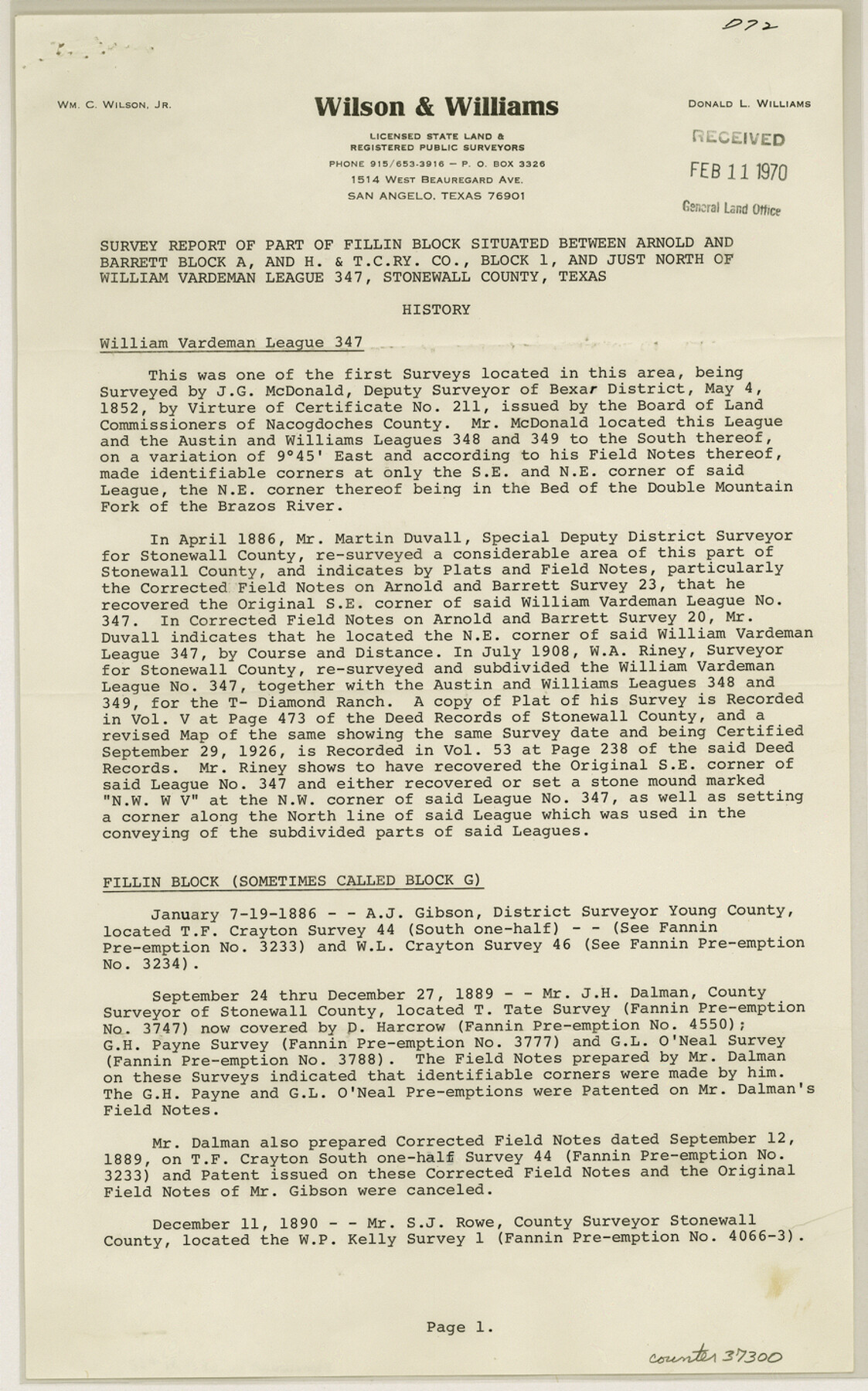
[Survey report and field notes of part of Fill-in Block situated between Arnold and Barrett Block A and H. & T. C. Ry. Co. Block 1 and just north of William Vardeman league 347]
-
Map/Doc
37300
-
Collection
General Map Collection
-
Object Dates
2/6/1970 (Creation Date)
2/11/1970 (File Date)
-
People and Organizations
William C. Wilson, Jr. (Surveyor/Engineer)
-
Counties
Stonewall
-
Subjects
Surveying Sketch File
-
Height x Width
14.3 x 8.9 inches
36.3 x 22.6 cm
-
Medium
paper, print
-
Features
Double Mountain Fork of Brazos River
T-Diamond Ranch
Part of: General Map Collection
Flight Mission No. DQO-3K, Frame 25, Galveston County

Print $20.00
- Digital $50.00
Flight Mission No. DQO-3K, Frame 25, Galveston County
1952
Size 18.8 x 22.4 inches
Map/Doc 85066
Fort Bend County Working Sketch 20

Print $20.00
- Digital $50.00
Fort Bend County Working Sketch 20
1967
Size 22.4 x 33.4 inches
Map/Doc 69226
Louisiana and Texas Intracoastal Waterway, Section 7, Galveston Bay to Brazos River and Section 8, Brazos River to Matagorda Bay

Print $20.00
- Digital $50.00
Louisiana and Texas Intracoastal Waterway, Section 7, Galveston Bay to Brazos River and Section 8, Brazos River to Matagorda Bay
1928
Size 30.7 x 42.9 inches
Map/Doc 61840
San Jacinto County Sketch File 13

Print $4.00
San Jacinto County Sketch File 13
Size 5.3 x 8.1 inches
Map/Doc 35723
Cameron County Working Sketch 3

Print $20.00
- Digital $50.00
Cameron County Working Sketch 3
1964
Size 40.8 x 38.6 inches
Map/Doc 67882
2016 Official Travel Map, Texas

2016 Official Travel Map, Texas
Size 33.3 x 36.2 inches
Map/Doc 94298
Lavaca County Working Sketch 3

Print $20.00
- Digital $50.00
Lavaca County Working Sketch 3
1928
Size 22.8 x 27.2 inches
Map/Doc 70356
Wichita County Sketch File 19

Print $20.00
- Digital $50.00
Wichita County Sketch File 19
Size 21.9 x 22.5 inches
Map/Doc 12681
Flight Mission No. CUG-1P, Frame 83, Kleberg County

Print $20.00
- Digital $50.00
Flight Mission No. CUG-1P, Frame 83, Kleberg County
1956
Size 18.5 x 22.2 inches
Map/Doc 86148
Maps of Gulf Intracoastal Waterway, Texas - Sabine River to the Rio Grande and connecting waterways including ship channels

Print $20.00
- Digital $50.00
Maps of Gulf Intracoastal Waterway, Texas - Sabine River to the Rio Grande and connecting waterways including ship channels
1966
Size 15.7 x 22.0 inches
Map/Doc 61986
Flight Mission No. DQN-2K, Frame 34, Calhoun County

Print $20.00
- Digital $50.00
Flight Mission No. DQN-2K, Frame 34, Calhoun County
1953
Size 18.5 x 22.2 inches
Map/Doc 84241
Martin County

Print $20.00
- Digital $50.00
Martin County
1933
Size 45.5 x 40.3 inches
Map/Doc 95580
You may also like
Borden County Rolled Sketch 11

Print $20.00
- Digital $50.00
Borden County Rolled Sketch 11
1963
Size 33.2 x 32.2 inches
Map/Doc 8450
Coryell County

Print $20.00
- Digital $50.00
Coryell County
1936
Size 44.6 x 40.1 inches
Map/Doc 77249
Gonzales County Sketch File 2

Print $10.00
- Digital $50.00
Gonzales County Sketch File 2
Size 8.9 x 7.8 inches
Map/Doc 24357
Kerr County Rolled Sketch 11A

Print $20.00
- Digital $50.00
Kerr County Rolled Sketch 11A
1950
Size 27.8 x 36.0 inches
Map/Doc 6496

McMullen County Sketch File 46

Print $6.00
- Digital $50.00
McMullen County Sketch File 46
1943
Size 14.3 x 8.7 inches
Map/Doc 31434
Flight Mission No. BRA-16M, Frame 72, Jefferson County

Print $20.00
- Digital $50.00
Flight Mission No. BRA-16M, Frame 72, Jefferson County
1953
Size 18.5 x 22.4 inches
Map/Doc 85689
Map of the Southern Pacific and connecting lines

Print $20.00
- Digital $50.00
Map of the Southern Pacific and connecting lines
1897
Size 8.7 x 15.9 inches
Map/Doc 95763
Travis County Sketch File 34

Print $26.00
- Digital $50.00
Travis County Sketch File 34
1888
Size 26.8 x 27.9 inches
Map/Doc 12461
Jeff Davis County Working Sketch 39

Print $40.00
- Digital $50.00
Jeff Davis County Working Sketch 39
1981
Size 52.1 x 38.0 inches
Map/Doc 66534
McMullen County Rolled Sketch 11

Print $20.00
- Digital $50.00
McMullen County Rolled Sketch 11
Size 32.2 x 22.3 inches
Map/Doc 6728
Sutton County Rolled Sketch H

Print $40.00
- Digital $50.00
Sutton County Rolled Sketch H
Size 24.9 x 50.0 inches
Map/Doc 9973