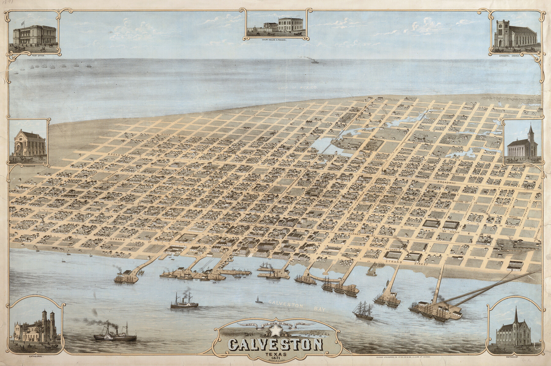
Bird's Eye View of the City of Galveston Texas
-
Map/Doc
89086
-
Collection
Non-GLO Digital Images
-
Object Dates
1871 (Creation Date)
-
People and Organizations
Chicago Lithographing Company (Printer)
Camille N. Drie (Draftsman)
-
Counties
Galveston
-
Subjects
Bird's Eye View City Pictorial
-
Height x Width
20.4 x 30.8 inches
51.8 x 78.2 cm
-
Comments
Bird's Eye View map. Public Domain image obtained from Wikimedia Commons.
Part of: Non-GLO Digital Images

Bird's Eye View of Bastrop, Bastrop County, Texas

Print $20.00
Bird's Eye View of Bastrop, Bastrop County, Texas
1887
Size 18.8 x 25.7 inches
Map/Doc 89073
Engineer map showing engineer information at 23 O'Clock 23 Oct. 1918 drawn under direction of Col. W.A. Mitchell - Verso

Print $20.00
Engineer map showing engineer information at 23 O'Clock 23 Oct. 1918 drawn under direction of Col. W.A. Mitchell - Verso
1918
Size 19.7 x 12.6 inches
Map/Doc 94128
Descripción y Mapa de la Nueva Provincia, poblada de Bárbaros, situada en la Costa del Seno Mexicano, desde el puerto de Tampico hasta la Provincia de Texas

Descripción y Mapa de la Nueva Provincia, poblada de Bárbaros, situada en la Costa del Seno Mexicano, desde el puerto de Tampico hasta la Provincia de Texas
1744
Size 32.0 x 29.1 inches
Map/Doc 94558
Bird's Eye View of Brenham, Washington County, Texas

Print $20.00
Bird's Eye View of Brenham, Washington County, Texas
1873
Size 20.0 x 25.7 inches
Map/Doc 89075
Plano del Presidio de Bahia dl Espiritus to dep te d' la Governacion de los Tejas

Plano del Presidio de Bahia dl Espiritus to dep te d' la Governacion de los Tejas
1766
Size 10.2 x 13.0 inches
Map/Doc 96516
El Nuevo Mexico y Tierras Adyacentes Mapa Levantado para la demarcacion de los Limites de los Dominios Españoles y de los Estados Unidos

Print $20.00
El Nuevo Mexico y Tierras Adyacentes Mapa Levantado para la demarcacion de los Limites de los Dominios Españoles y de los Estados Unidos
1811
Size 27.1 x 36.4 inches
Map/Doc 97477
[Movements & Objectives of the 143rd & 144th Infantry on October 9-11, 1918, Appendix E, Nos.2 and 3] - Verso
![94132, [Movements & Objectives of the 143rd & 144th Infantry on October 9-11, 1918, Appendix E, Nos.2 and 3] - Verso, Non-GLO Digital Images](https://historictexasmaps.com/wmedia_w700/maps/94132-1.tif.jpg)
Print $20.00
[Movements & Objectives of the 143rd & 144th Infantry on October 9-11, 1918, Appendix E, Nos.2 and 3] - Verso
1918
Size 41.9 x 20.2 inches
Map/Doc 94132
Plano del Presidio de Nra Senora del Pilar de los Adaes

Plano del Presidio de Nra Senora del Pilar de los Adaes
1766
Size 7.3 x 9.2 inches
Map/Doc 96517
Seymour, Baylor County, Texas

Print $20.00
Seymour, Baylor County, Texas
1890
Size 15.4 x 24.2 inches
Map/Doc 89207

Perspective Map of the City of Laredo, Texas, the Gateway to and from Mexico

Print $20.00
Perspective Map of the City of Laredo, Texas, the Gateway to and from Mexico
1892
Size 22.1 x 34.2 inches
Map/Doc 89098
You may also like
Jasper County Rolled Sketch 3

Print $20.00
- Digital $50.00
Jasper County Rolled Sketch 3
1944
Size 24.5 x 43.4 inches
Map/Doc 6350
Motley County Sketch File 28 (S)

Print $4.00
- Digital $50.00
Motley County Sketch File 28 (S)
Size 8.8 x 7.9 inches
Map/Doc 32211
Presidio County Working Sketch 19

Print $20.00
- Digital $50.00
Presidio County Working Sketch 19
1943
Size 32.9 x 40.3 inches
Map/Doc 71695
Ellis County Sketch File 16

Print $4.00
- Digital $50.00
Ellis County Sketch File 16
Size 13.1 x 8.3 inches
Map/Doc 21858
Flight Mission No. CGI-1N, Frame 166, Cameron County

Print $20.00
- Digital $50.00
Flight Mission No. CGI-1N, Frame 166, Cameron County
1955
Size 18.5 x 22.2 inches
Map/Doc 84501
Cochran County

Print $20.00
- Digital $50.00
Cochran County
1913
Size 29.1 x 20.0 inches
Map/Doc 4743
Current Miscellaneous File 88

Print $12.00
- Digital $50.00
Current Miscellaneous File 88
1954
Size 10.9 x 8.4 inches
Map/Doc 74247
Lynn County Sketch File 12

Print $4.00
- Digital $50.00
Lynn County Sketch File 12
1907
Size 7.5 x 8.7 inches
Map/Doc 30480
Sketch of Surveys in Knox County

Print $20.00
- Digital $50.00
Sketch of Surveys in Knox County
1896
Size 17.6 x 31.2 inches
Map/Doc 75788
General Topographical Map. Sheet XXII

Print $20.00
- Digital $50.00
General Topographical Map. Sheet XXII
1891
Size 18.4 x 29.4 inches
Map/Doc 97526
Galveston County Sketch File 51

Print $20.00
- Digital $50.00
Galveston County Sketch File 51
1895
Size 25.7 x 40.2 inches
Map/Doc 10457
[Surveys in the Milam District along the Brazos River, North Bosque River, West Bosque River and Cow Bayou]
![231, [Surveys in the Milam District along the Brazos River, North Bosque River, West Bosque River and Cow Bayou], General Map Collection](https://historictexasmaps.com/wmedia_w700/maps/231.tif.jpg)
Print $2.00
- Digital $50.00
[Surveys in the Milam District along the Brazos River, North Bosque River, West Bosque River and Cow Bayou]
1846
Size 11.7 x 8.9 inches
Map/Doc 231