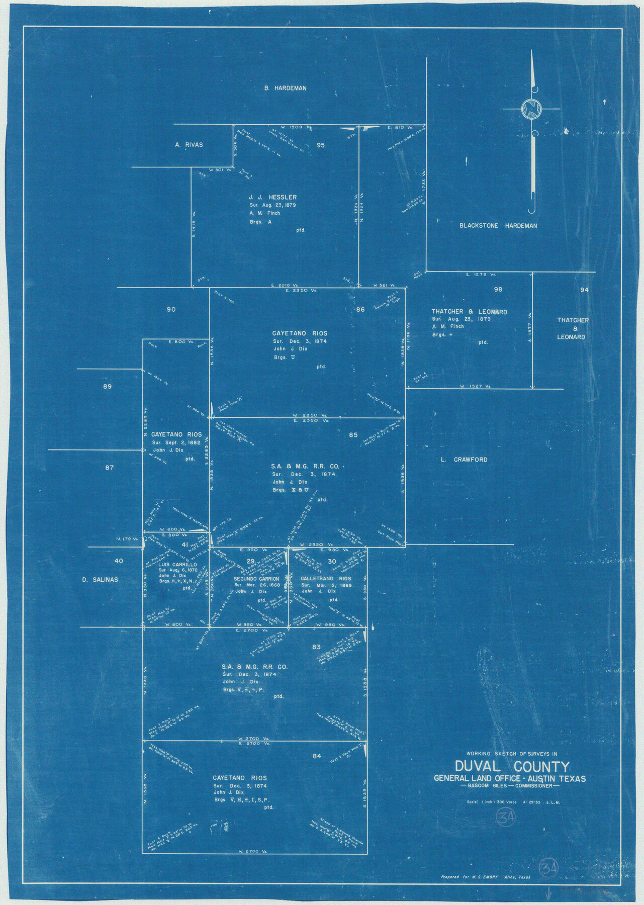
Duval County Working Sketch 34
-
Map/Doc
68758
-
Collection
General Map Collection
-
Object Dates
4/29/1953 (Creation Date)
-
Counties
Duval
-
Subjects
Surveying Working Sketch
-
Height x Width
35.8 x 25.5 inches
90.9 x 64.8 cm
-
Scale
1" = 300 varas
Part of: General Map Collection
[Sketch of Col. Cooke's Military Road expedition from Red River to Austin]
![166, [Sketch of Col. Cooke's Military Road expedition from Red River to Austin], General Map Collection](https://historictexasmaps.com/wmedia_w700/maps/166.tif.jpg)
Print $20.00
- Digital $50.00
[Sketch of Col. Cooke's Military Road expedition from Red River to Austin]
Size 29.4 x 22.9 inches
Map/Doc 166
Edwards County Working Sketch 37

Print $20.00
- Digital $50.00
Edwards County Working Sketch 37
1948
Size 23.1 x 35.5 inches
Map/Doc 68913
Carson County Sketch File 3

Print $32.00
- Digital $50.00
Carson County Sketch File 3
1888
Size 5.4 x 8.4 inches
Map/Doc 17335
Crockett County Rolled Sketch 86

Print $20.00
- Digital $50.00
Crockett County Rolled Sketch 86
1947
Size 31.2 x 27.1 inches
Map/Doc 5626
Starr County Rolled Sketch 31

Print $20.00
- Digital $50.00
Starr County Rolled Sketch 31
1941
Size 22.5 x 32.6 inches
Map/Doc 7828
Runnels County Working Sketch Graphic Index

Print $20.00
- Digital $50.00
Runnels County Working Sketch Graphic Index
1948
Size 46.8 x 36.9 inches
Map/Doc 76687
Flight Mission No. CGI-3N, Frame 140, Cameron County

Print $20.00
- Digital $50.00
Flight Mission No. CGI-3N, Frame 140, Cameron County
1954
Size 18.8 x 22.5 inches
Map/Doc 84613
Chambers County Boundary File 3

Print $112.00
- Digital $50.00
Chambers County Boundary File 3
Size 52.5 x 3.9 inches
Map/Doc 51249
Flight Mission No. CLL-1N, Frame 88, Willacy County

Print $20.00
- Digital $50.00
Flight Mission No. CLL-1N, Frame 88, Willacy County
1954
Size 18.4 x 22.1 inches
Map/Doc 87034
[Surveys in the Liberty District in Tyler and Polk Counties]
![331, [Surveys in the Liberty District in Tyler and Polk Counties], General Map Collection](https://historictexasmaps.com/wmedia_w700/maps/331.tif.jpg)
Print $2.00
- Digital $50.00
[Surveys in the Liberty District in Tyler and Polk Counties]
1847
Size 5.9 x 8.4 inches
Map/Doc 331
Brazoria County Boundary File 2

Print $140.00
- Digital $50.00
Brazoria County Boundary File 2
Size 12.8 x 9.8 inches
Map/Doc 50704

You may also like
Cottle County Working Sketch 23

Print $20.00
- Digital $50.00
Cottle County Working Sketch 23
1992
Size 26.6 x 24.2 inches
Map/Doc 68333
Nueces County Sketch File 72

Print $13.00
- Digital $50.00
Nueces County Sketch File 72
1991
Size 11.1 x 8.8 inches
Map/Doc 33020
Flight Mission No. BQR-9K, Frame 11, Brazoria County

Print $20.00
- Digital $50.00
Flight Mission No. BQR-9K, Frame 11, Brazoria County
1952
Size 18.7 x 22.4 inches
Map/Doc 84040
Hutchinson County Sketch File 21

Print $22.00
- Digital $50.00
Hutchinson County Sketch File 21
Size 8.8 x 7.9 inches
Map/Doc 27242
Flight Mission No. CRC-1R, Frame 34, Chambers County

Print $20.00
- Digital $50.00
Flight Mission No. CRC-1R, Frame 34, Chambers County
1956
Size 18.8 x 22.4 inches
Map/Doc 84702
Topographical Map of the City of Austin

Print $20.00
- Digital $50.00
Topographical Map of the City of Austin
1887
Size 43.1 x 41.1 inches
Map/Doc 2189
Martin County Working Sketch 3

Print $20.00
- Digital $50.00
Martin County Working Sketch 3
1950
Size 40.9 x 46.2 inches
Map/Doc 70821
Map of Texas with population and location of principal towns and cities according to latest reliable statistics

Print $20.00
- Digital $50.00
Map of Texas with population and location of principal towns and cities according to latest reliable statistics
1912
Size 18.0 x 20.2 inches
Map/Doc 95876
[Map of Counties South of Panhandle from Parmer to Childress in North to Andrews to Eastland in the South]
![92098, [Map of Counties South of Panhandle from Parmer to Childress in North to Andrews to Eastland in the South], Twichell Survey Records](https://historictexasmaps.com/wmedia_w700/maps/92098-2.tif.jpg)
Print $3.00
- Digital $50.00
[Map of Counties South of Panhandle from Parmer to Childress in North to Andrews to Eastland in the South]
Size 14.9 x 10.7 inches
Map/Doc 92098
[G. & M. Block 5]
![91802, [G. & M. Block 5], Twichell Survey Records](https://historictexasmaps.com/wmedia_w700/maps/91802-1.tif.jpg)
Print $20.00
- Digital $50.00
[G. & M. Block 5]
Size 20.3 x 12.5 inches
Map/Doc 91802
Motley County Sketch File 10 (N)

Print $20.00
- Digital $50.00
Motley County Sketch File 10 (N)
1900
Size 14.0 x 8.5 inches
Map/Doc 32026
Bandera County Rolled Sketch 11

Print $20.00
- Digital $50.00
Bandera County Rolled Sketch 11
Size 30.8 x 41.1 inches
Map/Doc 77503