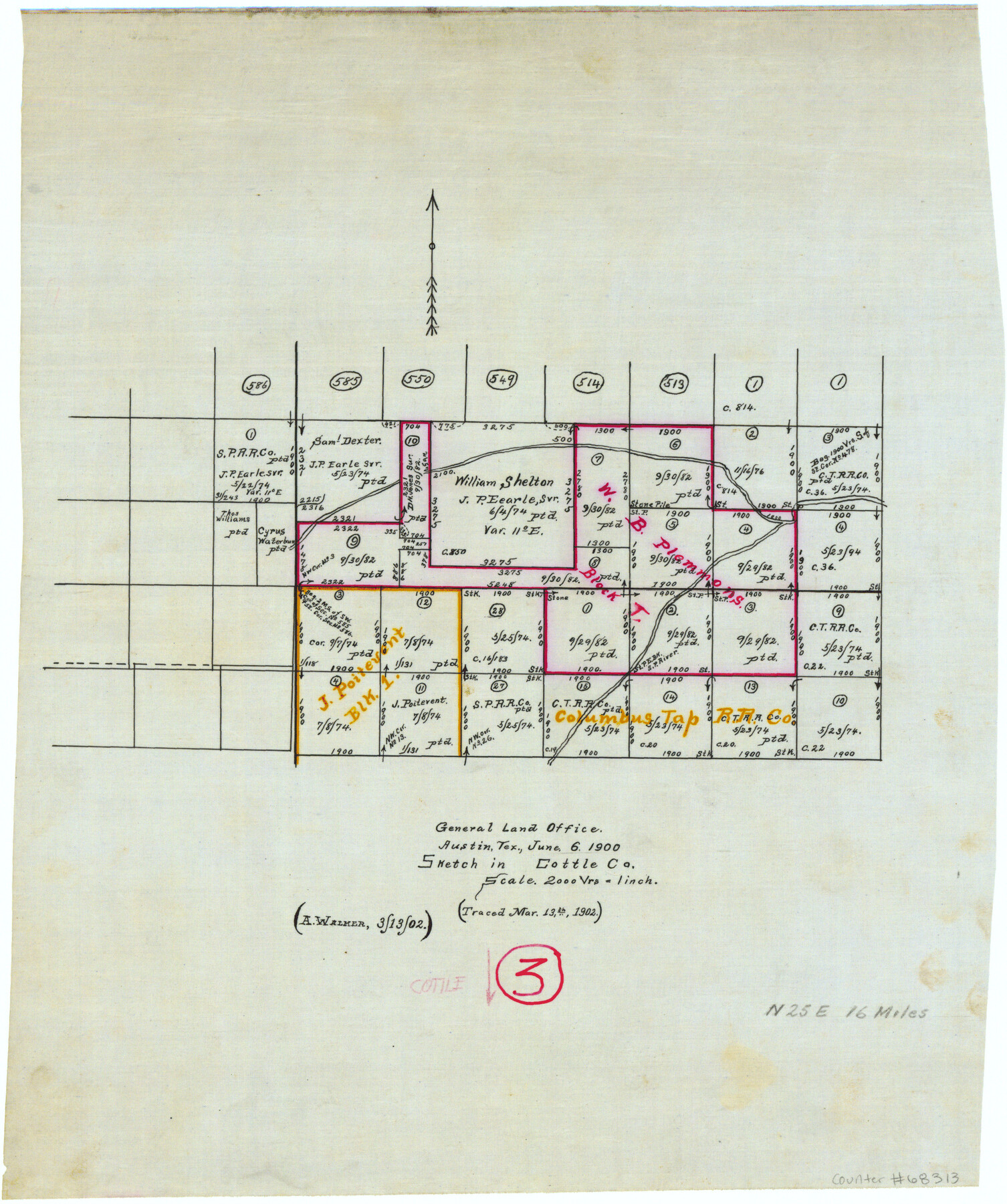
Cottle County Working Sketch 3
-
Map/Doc
68313
-
Collection
General Map Collection
-
Object Dates
6/6/1900 (Creation Date)
3/13/1902 (Tracing Date)
-
Counties
Cottle
-
Subjects
Surveying Working Sketch
-
Height x Width
13.6 x 11.4 inches
34.5 x 29.0 cm
-
Scale
1" = 2000 varas
Part of: General Map Collection
Loving County Working Sketch 15

Print $20.00
- Digital $50.00
Loving County Working Sketch 15
1973
Size 47.3 x 34.5 inches
Map/Doc 70648
[Sketch for Mineral Application 16341 - Clear Fork of Brazos River, Taylor & Holcomb]
![65572, [Sketch for Mineral Application 16341 - Clear Fork of Brazos River, Taylor & Holcomb], General Map Collection](https://historictexasmaps.com/wmedia_w700/maps/65572.tif.jpg)
Print $40.00
- Digital $50.00
[Sketch for Mineral Application 16341 - Clear Fork of Brazos River, Taylor & Holcomb]
1926
Size 122.8 x 39.6 inches
Map/Doc 65572
Baylor County Boundary File 1

Print $25.00
- Digital $50.00
Baylor County Boundary File 1
Size 9.3 x 8.4 inches
Map/Doc 50347
Kinney County Working Sketch 31

Print $20.00
- Digital $50.00
Kinney County Working Sketch 31
1961
Size 30.9 x 47.3 inches
Map/Doc 70213
King County Working Sketch 11

Print $40.00
- Digital $50.00
King County Working Sketch 11
1971
Size 49.7 x 25.0 inches
Map/Doc 70175
Concho, San Saba & Llano Valley Railway, Sterling City Branch, Texas. Right of Way and Track Map

Print $40.00
- Digital $50.00
Concho, San Saba & Llano Valley Railway, Sterling City Branch, Texas. Right of Way and Track Map
1910
Size 18.3 x 59.7 inches
Map/Doc 64439
Kerr County Working Sketch 5

Print $20.00
- Digital $50.00
Kerr County Working Sketch 5
1947
Size 21.9 x 19.8 inches
Map/Doc 70036
Stephens County Working Sketch 35

Print $20.00
- Digital $50.00
Stephens County Working Sketch 35
1978
Size 14.5 x 26.0 inches
Map/Doc 63978
Milam County Rolled Sketch 1

Print $20.00
- Digital $50.00
Milam County Rolled Sketch 1
1952
Size 31.2 x 40.3 inches
Map/Doc 6773
[Surveys along the San Antonio and Cibolo Rivers]
![69, [Surveys along the San Antonio and Cibolo Rivers], General Map Collection](https://historictexasmaps.com/wmedia_w700/maps/69.tif.jpg)
Print $20.00
- Digital $50.00
[Surveys along the San Antonio and Cibolo Rivers]
Size 16.9 x 20.2 inches
Map/Doc 69
Sutton County Working Sketch 56

Print $20.00
- Digital $50.00
Sutton County Working Sketch 56
1958
Size 27.6 x 28.8 inches
Map/Doc 62399
Marion County Working Sketch 3

Print $20.00
- Digital $50.00
Marion County Working Sketch 3
Size 34.9 x 30.0 inches
Map/Doc 70778
You may also like
Gonzales County Working Sketch 1

Print $40.00
- Digital $50.00
Gonzales County Working Sketch 1
1913
Size 16.8 x 49.8 inches
Map/Doc 63216
Irion County Sketch File 17

Print $20.00
- Digital $50.00
Irion County Sketch File 17
Size 26.7 x 40.5 inches
Map/Doc 10617
Collin County Boundary File 18c

Print $12.00
- Digital $50.00
Collin County Boundary File 18c
Size 12.9 x 8.1 inches
Map/Doc 51733
[Sketch showing I. G. Yates SF 12341 and surrounding surveys]
![93106, [Sketch showing I. G. Yates SF 12341 and surrounding surveys], Twichell Survey Records](https://historictexasmaps.com/wmedia_w700/maps/93106-1.tif.jpg)
Print $20.00
- Digital $50.00
[Sketch showing I. G. Yates SF 12341 and surrounding surveys]
Size 25.9 x 21.6 inches
Map/Doc 93106
Travis County State Real Property Sketch 10

Print $20.00
- Digital $50.00
Travis County State Real Property Sketch 10
2002
Size 35.5 x 25.2 inches
Map/Doc 83550
Hays County State Real Property Sketch 3

Print $20.00
- Digital $50.00
Hays County State Real Property Sketch 3
2003
Size 24.0 x 37.2 inches
Map/Doc 96638
Flight Mission No. DQN-2K, Frame 26, Calhoun County

Print $20.00
- Digital $50.00
Flight Mission No. DQN-2K, Frame 26, Calhoun County
1953
Size 18.6 x 22.2 inches
Map/Doc 84233
Harris County NRC Article 33.136 Location Key Sheet

Print $20.00
- Digital $50.00
Harris County NRC Article 33.136 Location Key Sheet
1995
Size 27.0 x 21.8 inches
Map/Doc 82992
Flight Mission No. DQN-2K, Frame 146, Calhoun County

Print $20.00
- Digital $50.00
Flight Mission No. DQN-2K, Frame 146, Calhoun County
1953
Size 18.9 x 22.5 inches
Map/Doc 84315
Map of Runnels Co[unty]
![88991, Map of Runnels Co[unty], Library of Congress](https://historictexasmaps.com/wmedia_w700/maps/88991.tif.jpg)
Print $20.00
Map of Runnels Co[unty]
1879
Size 24.5 x 18.2 inches
Map/Doc 88991
Presidio County Sketch File 14

Print $52.00
- Digital $50.00
Presidio County Sketch File 14
1883
Size 15.3 x 18.8 inches
Map/Doc 11707
Galveston County Rolled Sketch 46

Print $40.00
- Digital $50.00
Galveston County Rolled Sketch 46
2000
Size 32.0 x 48.3 inches
Map/Doc 5981