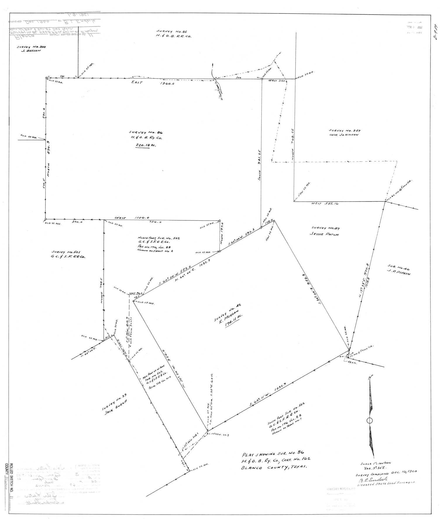
Blanco County Rolled Sketch 11
Plat showing sur. No. 86, H. & O. B. R.R. Co., cert. no. 162
-
Map/Doc
5147
-
Collection
General Map Collection
-
Object Dates
1960/12/16 (Survey Date)
1961/1/9 (File Date)
-
People and Organizations
B.L. Enderle (Surveyor/Engineer)
-
Counties
Blanco
-
Subjects
Surveying Rolled Sketch
-
Height x Width
33.2 x 27.8 inches
84.3 x 70.6 cm
-
Scale
1" = 100 varas
Part of: General Map Collection
Hemphill County Working Sketch 10

Print $20.00
- Digital $50.00
Hemphill County Working Sketch 10
1965
Size 23.5 x 35.7 inches
Map/Doc 66105
Corpus Christi Pass

Print $20.00
- Digital $50.00
Corpus Christi Pass
Size 45.7 x 41.2 inches
Map/Doc 78454
Glasscock County Rolled Sketch 12

Print $20.00
- Digital $50.00
Glasscock County Rolled Sketch 12
1957
Size 19.6 x 16.1 inches
Map/Doc 6018
Refugio County Sketch File 10

Print $4.00
- Digital $50.00
Refugio County Sketch File 10
Size 8.2 x 9.4 inches
Map/Doc 35258
Callahan County Rolled Sketch 1

Print $20.00
- Digital $50.00
Callahan County Rolled Sketch 1
1944
Size 26.9 x 26.3 inches
Map/Doc 5379
Jefferson County Working Sketch 4

Print $20.00
- Digital $50.00
Jefferson County Working Sketch 4
1930
Size 19.4 x 28.0 inches
Map/Doc 66547
Flight Mission No. BRA-7M, Frame 79, Jefferson County

Print $20.00
- Digital $50.00
Flight Mission No. BRA-7M, Frame 79, Jefferson County
1953
Size 16.0 x 15.8 inches
Map/Doc 85501
Denton County Sketch File 27

Print $4.00
- Digital $50.00
Denton County Sketch File 27
1858
Size 7.9 x 12.1 inches
Map/Doc 20754
Mineral Locality Map of Texas Showing Occurances of Useful Minerals, Rocks, Oil and Gas, and Other Geologic Substances

Print $40.00
- Digital $50.00
Mineral Locality Map of Texas Showing Occurances of Useful Minerals, Rocks, Oil and Gas, and Other Geologic Substances
1945
Size 43.8 x 53.0 inches
Map/Doc 94140


Frio County Working Sketch 20

Print $20.00
- Digital $50.00
Frio County Working Sketch 20
1985
Size 36.3 x 36.0 inches
Map/Doc 69294
You may also like
Stephens County Working Sketch 1

Print $20.00
- Digital $50.00
Stephens County Working Sketch 1
Size 13.5 x 16.1 inches
Map/Doc 63944
San Jacinto County Working Sketch 3

Print $20.00
- Digital $50.00
San Jacinto County Working Sketch 3
1926
Size 16.7 x 19.7 inches
Map/Doc 63716
Old Miscellaneous File 23

Print $58.00
- Digital $50.00
Old Miscellaneous File 23
1919
Size 14.2 x 8.6 inches
Map/Doc 75600
Walker County Working Sketch 18

Print $20.00
- Digital $50.00
Walker County Working Sketch 18
1991
Size 29.4 x 31.5 inches
Map/Doc 72298
Map of Duval County

Print $40.00
- Digital $50.00
Map of Duval County
1890
Size 69.8 x 43.8 inches
Map/Doc 4936
Terrell County Working Sketch 42

Print $20.00
- Digital $50.00
Terrell County Working Sketch 42
1957
Size 34.4 x 34.4 inches
Map/Doc 62135
Right of Way and Track Map Houston & Texas Central R.R. operated by the T. & N.O. R.R. Co., Austin Branch

Print $40.00
- Digital $50.00
Right of Way and Track Map Houston & Texas Central R.R. operated by the T. & N.O. R.R. Co., Austin Branch
1918
Size 25.6 x 57.8 inches
Map/Doc 64555

Clay County Working Sketch 13

Print $20.00
- Digital $50.00
Clay County Working Sketch 13
1955
Size 14.7 x 14.3 inches
Map/Doc 68036
Flight Mission No. BRA-9M, Frame 72, Jefferson County

Print $20.00
- Digital $50.00
Flight Mission No. BRA-9M, Frame 72, Jefferson County
1953
Size 18.5 x 22.6 inches
Map/Doc 85655
Stonewall County Working Sketch 25

Print $20.00
- Digital $50.00
Stonewall County Working Sketch 25
1973
Size 29.5 x 23.4 inches
Map/Doc 62332
Cottle County Working Sketch 23

Print $20.00
- Digital $50.00
Cottle County Working Sketch 23
1992
Size 26.6 x 24.2 inches
Map/Doc 68333