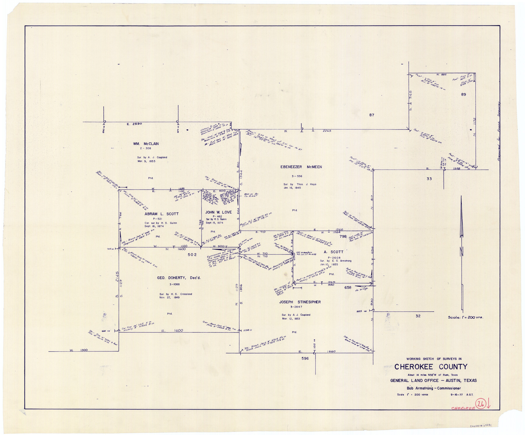
Cherokee County Working Sketch 26
-
Map/Doc
67981
-
Collection
General Map Collection
-
Object Dates
9/16/1977 (Creation Date)
-
Counties
Cherokee
-
Subjects
Surveying Working Sketch
-
Height x Width
28.9 x 34.9 inches
73.4 x 88.7 cm
-
Scale
1" = 200 varas
Part of: General Map Collection
Map of Parker County

Print $20.00
- Digital $50.00
Map of Parker County
1879
Size 23.9 x 19.0 inches
Map/Doc 3947
Reagan County Rolled Sketch 27A

Print $40.00
- Digital $50.00
Reagan County Rolled Sketch 27A
1952
Size 63.7 x 47.2 inches
Map/Doc 9822
Map of Texas from the most recent authorities

Print $20.00
- Digital $50.00
Map of Texas from the most recent authorities
1845
Size 14.2 x 18.0 inches
Map/Doc 96628
Flight Mission No. CLL-1N, Frame 105, Willacy County

Print $20.00
- Digital $50.00
Flight Mission No. CLL-1N, Frame 105, Willacy County
1954
Size 18.4 x 22.1 inches
Map/Doc 87039

El Paso County Working Sketch 3

Print $20.00
- Digital $50.00
El Paso County Working Sketch 3
1916
Size 26.9 x 41.3 inches
Map/Doc 69025
Map of Colorado County

Print $20.00
- Digital $50.00
Map of Colorado County
1880
Size 21.8 x 21.1 inches
Map/Doc 3426
Archer County Sketch File 27

Print $40.00
- Digital $50.00
Archer County Sketch File 27
Size 19.1 x 21.1 inches
Map/Doc 10833
Leon County Working Sketch 42

Print $40.00
- Digital $50.00
Leon County Working Sketch 42
1980
Size 56.8 x 42.8 inches
Map/Doc 70441
Kinney County Working Sketch 51

Print $20.00
- Digital $50.00
Kinney County Working Sketch 51
1980
Size 34.6 x 47.2 inches
Map/Doc 70233
Gulf Shore of Galveston Island Texas Shoreline and Offshore Depth Changes - Sheet 1

Print $20.00
- Digital $50.00
Gulf Shore of Galveston Island Texas Shoreline and Offshore Depth Changes - Sheet 1
1949
Size 30.9 x 40.8 inches
Map/Doc 61825
Fort Bend County State Real Property Sketch 7

Print $40.00
- Digital $50.00
Fort Bend County State Real Property Sketch 7
1985
Size 34.7 x 44.3 inches
Map/Doc 61681
You may also like
Hood County Working Sketch 15

Print $20.00
- Digital $50.00
Hood County Working Sketch 15
1985
Size 30.0 x 28.2 inches
Map/Doc 66209
San Jacinto County Working Sketch 20

Print $20.00
- Digital $50.00
San Jacinto County Working Sketch 20
1939
Size 30.3 x 24.0 inches
Map/Doc 63733
[Sketch showing surveys located in Block 6]
![91751, [Sketch showing surveys located in Block 6], Twichell Survey Records](https://historictexasmaps.com/wmedia_w700/maps/91751-1.tif.jpg)
Print $20.00
- Digital $50.00
[Sketch showing surveys located in Block 6]
Size 19.7 x 15.8 inches
Map/Doc 91751

Hartley County

Print $40.00
- Digital $50.00
Hartley County
1923
Size 42.1 x 49.5 inches
Map/Doc 95524
Flight Mission No. DCL-7C, Frame 57, Kenedy County

Print $20.00
- Digital $50.00
Flight Mission No. DCL-7C, Frame 57, Kenedy County
1943
Size 15.4 x 15.2 inches
Map/Doc 86045
San Jacinto County Working Sketch 41

Print $20.00
- Digital $50.00
San Jacinto County Working Sketch 41
1979
Size 44.6 x 35.2 inches
Map/Doc 63754
Hays County Boundary File

Print $120.00
- Digital $50.00
Hays County Boundary File
1947
Size 33.6 x 20.8 inches
Map/Doc 65496
Sabine River, Dixon Sheet/Cowleach Fork of the Sabine River

Print $20.00
- Digital $50.00
Sabine River, Dixon Sheet/Cowleach Fork of the Sabine River
1935
Size 44.0 x 18.5 inches
Map/Doc 65145
Jeff Davis County Rolled Sketch 37

Print $20.00
- Digital $50.00
Jeff Davis County Rolled Sketch 37
1992
Size 29.3 x 35.5 inches
Map/Doc 6380
Morris County Rolled Sketch 2A

Print $64.00
- Digital $50.00
Morris County Rolled Sketch 2A
1944
Size 11.2 x 8.8 inches
Map/Doc 41667
Johnson County Rolled Sketch B

Print $20.00
- Digital $50.00
Johnson County Rolled Sketch B
1891
Size 28.2 x 38.9 inches
Map/Doc 6449