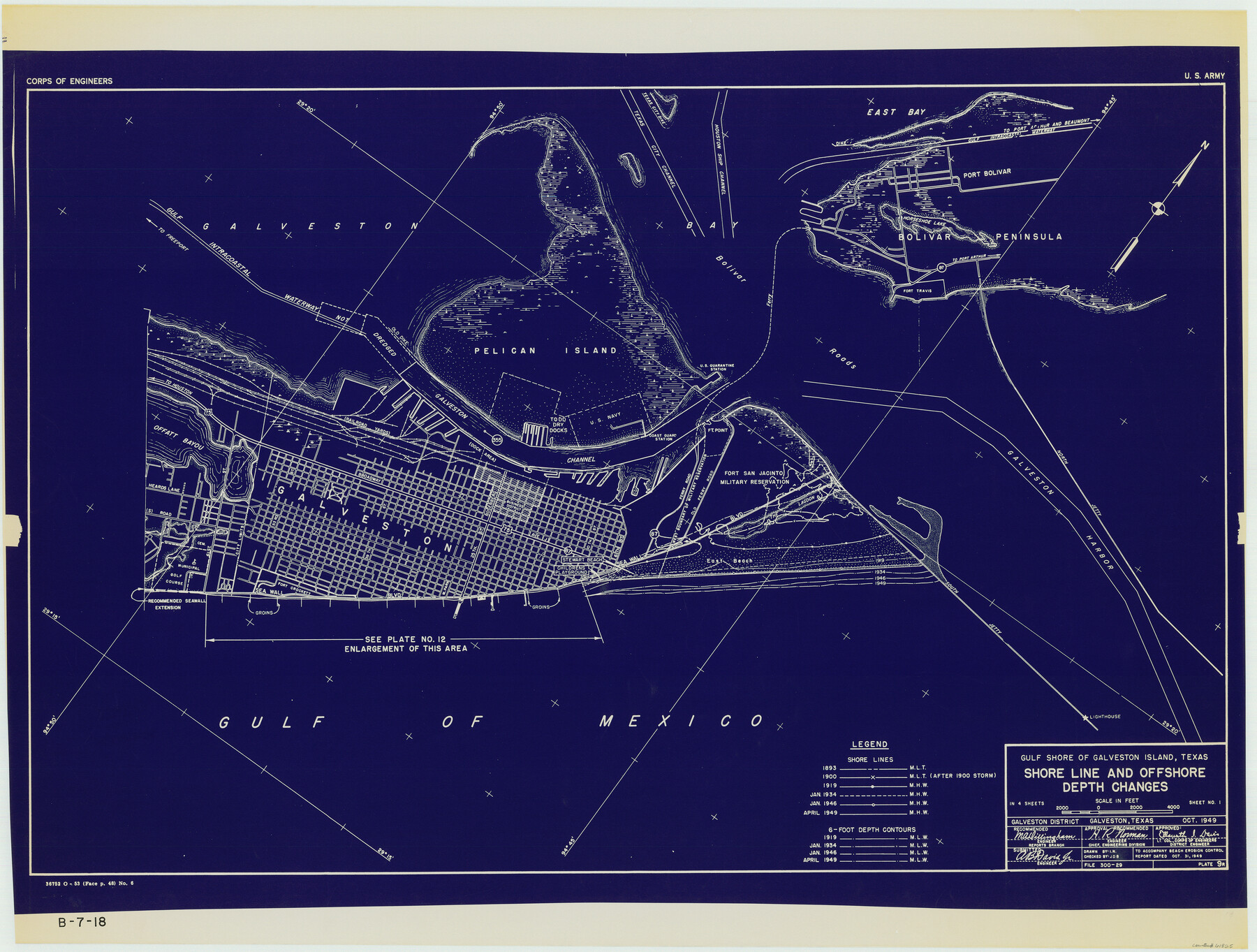
Gulf Shore of Galveston Island Texas Shoreline and Offshore Depth Changes - Sheet 1
B-7-18
-
Map/Doc
61825
-
Collection
General Map Collection
-
Object Dates
1949 (Creation Date)
-
Subjects
Nautical Charts
-
Height x Width
30.9 x 40.8 inches
78.5 x 103.6 cm
Part of: General Map Collection
No. 3 Chart of Channel connecting Corpus Christi Bay with Aransas Bay, Texas

Print $20.00
- Digital $50.00
No. 3 Chart of Channel connecting Corpus Christi Bay with Aransas Bay, Texas
1878
Size 18.4 x 28.0 inches
Map/Doc 72775
Fayette County Working Sketch 7

Print $20.00
- Digital $50.00
Fayette County Working Sketch 7
1981
Size 24.1 x 15.6 inches
Map/Doc 69171
Coleman County Working Sketch 22

Print $20.00
- Digital $50.00
Coleman County Working Sketch 22
1953
Size 34.6 x 41.0 inches
Map/Doc 68088
Atascosa County Sketch File 1

Print $8.00
- Digital $50.00
Atascosa County Sketch File 1
Size 8.1 x 6.1 inches
Map/Doc 13718
Cottle County Sketch File 16

Print $8.00
- Digital $50.00
Cottle County Sketch File 16
1911
Size 10.7 x 8.7 inches
Map/Doc 19518
Orange County Rolled Sketch 19

Print $20.00
- Digital $50.00
Orange County Rolled Sketch 19
1945
Size 16.2 x 24.7 inches
Map/Doc 7183

Sutton County Working Sketch 65

Print $20.00
- Digital $50.00
Sutton County Working Sketch 65
1963
Size 20.4 x 39.5 inches
Map/Doc 62408
Panola County Working Sketch 13

Print $40.00
- Digital $50.00
Panola County Working Sketch 13
1945
Map/Doc 71422
Orange County Sketch File 24

Print $6.00
- Digital $50.00
Orange County Sketch File 24
Size 8.9 x 15.7 inches
Map/Doc 33353
Brewster County Rolled Sketch 19A

Print $20.00
- Digital $50.00
Brewster County Rolled Sketch 19A
1881
Size 31.5 x 38.6 inches
Map/Doc 8471
Castro County Rolled Sketch 13

Print $20.00
- Digital $50.00
Castro County Rolled Sketch 13
1967
Size 18.7 x 20.1 inches
Map/Doc 5422
You may also like
Map of the United States and Mexico showing the Trans-Union and Tehuantepec route between Europe and Asia

Print $20.00
- Digital $50.00
Map of the United States and Mexico showing the Trans-Union and Tehuantepec route between Europe and Asia
1851
Size 20.3 x 23.7 inches
Map/Doc 94851
[Surveys along the Trinity River]
![350, [Surveys along the Trinity River], General Map Collection](https://historictexasmaps.com/wmedia_w700/maps/350.tif.jpg)
Print $20.00
- Digital $50.00
[Surveys along the Trinity River]
1846
Size 12.6 x 14.7 inches
Map/Doc 350


Montague County Rolled Sketch 9

Print $20.00
- Digital $50.00
Montague County Rolled Sketch 9
Size 29.1 x 39.4 inches
Map/Doc 6793
Bandera County Boundary File 2

Print $4.00
- Digital $50.00
Bandera County Boundary File 2
Size 9.1 x 7.5 inches
Map/Doc 50264
Presidio County Rolled Sketch 34

Print $20.00
- Digital $50.00
Presidio County Rolled Sketch 34
1890
Size 46.1 x 32.9 inches
Map/Doc 9773
Bexar County Working Sketch 10

Print $20.00
- Digital $50.00
Bexar County Working Sketch 10
1959
Size 22.6 x 34.5 inches
Map/Doc 67326
Pecos County Rolled Sketch 153

Print $20.00
- Digital $50.00
Pecos County Rolled Sketch 153
1960
Size 20.2 x 22.7 inches
Map/Doc 7282
Cameron County Rolled Sketch 18

Print $64.00
- Digital $50.00
Cameron County Rolled Sketch 18
1970
Size 48.9 x 57.1 inches
Map/Doc 8571
Hunt County Sketch File 12

Print $40.00
- Digital $50.00
Hunt County Sketch File 12
1852
Size 12.7 x 16.0 inches
Map/Doc 27104
Flight Mission No. CRC-4R, Frame 104, Chambers County

Print $20.00
- Digital $50.00
Flight Mission No. CRC-4R, Frame 104, Chambers County
1956
Size 18.6 x 22.4 inches
Map/Doc 84901