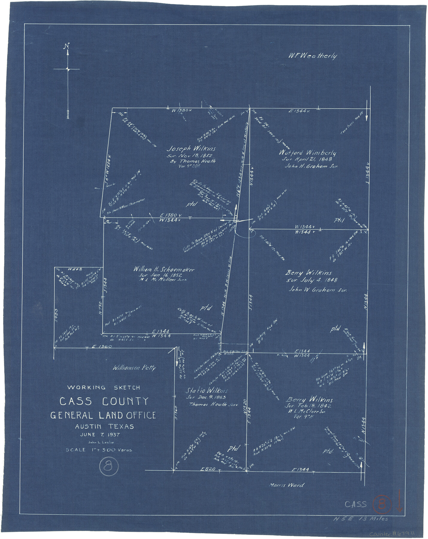
Cass County Working Sketch 8
-
Map/Doc
67911
-
Collection
General Map Collection
-
Object Dates
6/7/1937 (Creation Date)
-
People and Organizations
John L. Leslie (Draftsman)
-
Counties
Cass
-
Subjects
Surveying Working Sketch
-
Height x Width
20.2 x 16.1 inches
51.3 x 40.9 cm
-
Scale
1" = 300 varas
Part of: General Map Collection
Right of Way & Track Map, St. Louis, Brownsville & Mexico Ry. operated by St. Louis, Brownsville & Mexico Ry. Co.

Print $40.00
- Digital $50.00
Right of Way & Track Map, St. Louis, Brownsville & Mexico Ry. operated by St. Louis, Brownsville & Mexico Ry. Co.
1919
Size 25.7 x 57.4 inches
Map/Doc 64617
Nueces County Sketch File 50

Print $463.00
- Digital $50.00
Nueces County Sketch File 50
Size 9.6 x 6.2 inches
Map/Doc 32673
Andrews County Rolled Sketch 6

Print $40.00
- Digital $50.00
Andrews County Rolled Sketch 6
1928
Size 43.9 x 56.9 inches
Map/Doc 8363
Flight Mission No. DCL-7C, Frame 118, Kenedy County

Print $20.00
- Digital $50.00
Flight Mission No. DCL-7C, Frame 118, Kenedy County
1943
Size 18.4 x 22.3 inches
Map/Doc 86083
Mappa Geographica Complectens I. Indiae Occidentalis Partem Mediam Circum Isthmum Panamensem; II. Ipsumque Isthmum; III. Ichnographiam praecipuorum locorum & portuum ad has terras pertinentium

Print $20.00
- Digital $50.00
Mappa Geographica Complectens I. Indiae Occidentalis Partem Mediam Circum Isthmum Panamensem; II. Ipsumque Isthmum; III. Ichnographiam praecipuorum locorum & portuum ad has terras pertinentium
1740
Size 24.6 x 22.6 inches
Map/Doc 93693
Brazoria County Sketch File 41

Print $40.00
- Digital $50.00
Brazoria County Sketch File 41
1939
Size 19.5 x 26.6 inches
Map/Doc 10960
Township and Railroad Map of New Hampshire compiled from the best authorities with corrections and alteration of town lines from actual surveys

Print $20.00
- Digital $50.00
Township and Railroad Map of New Hampshire compiled from the best authorities with corrections and alteration of town lines from actual surveys
1854
Size 34.8 x 24.4 inches
Map/Doc 97105
Briscoe County Sketch File 4

Print $40.00
- Digital $50.00
Briscoe County Sketch File 4
Size 26.0 x 33.5 inches
Map/Doc 10993
Foard County Working Sketch 5b

Print $20.00
- Digital $50.00
Foard County Working Sketch 5b
Size 18.4 x 24.2 inches
Map/Doc 69196
United States - Gulf Coast - From Latitude 26° 33' to the Rio Grande Texas

Print $20.00
- Digital $50.00
United States - Gulf Coast - From Latitude 26° 33' to the Rio Grande Texas
1918
Size 27.1 x 18.4 inches
Map/Doc 72852
Rio Grande Rectification Project, El Paso and Juarez Valley

Print $20.00
- Digital $50.00
Rio Grande Rectification Project, El Paso and Juarez Valley
1935
Size 10.7 x 29.6 inches
Map/Doc 60865
Flight Mission No. BRA-7M, Frame 200, Jefferson County

Print $20.00
- Digital $50.00
Flight Mission No. BRA-7M, Frame 200, Jefferson County
1953
Size 18.8 x 22.4 inches
Map/Doc 85568
You may also like
Right-of-Way and Track Map, Texas State Railroad operated by the T. and N. O. R.R. Co.

Print $40.00
- Digital $50.00
Right-of-Way and Track Map, Texas State Railroad operated by the T. and N. O. R.R. Co.
1917
Size 24.8 x 56.3 inches
Map/Doc 64173
Galveston Island, showing division into lots

Print $40.00
- Digital $50.00
Galveston Island, showing division into lots
1839
Size 76.9 x 33.3 inches
Map/Doc 2036
Scurry County Working Sketch 7

Print $20.00
- Digital $50.00
Scurry County Working Sketch 7
1971
Size 33.5 x 29.0 inches
Map/Doc 63836
Somervell County Working Sketch 2

Print $20.00
- Digital $50.00
Somervell County Working Sketch 2
1951
Size 22.4 x 23.8 inches
Map/Doc 63906
Flight Mission No. BRA-16M, Frame 176, Jefferson County

Print $20.00
- Digital $50.00
Flight Mission No. BRA-16M, Frame 176, Jefferson County
1953
Size 18.7 x 22.3 inches
Map/Doc 85774
Flight Mission No. BRE-2P, Frame 21, Nueces County

Print $20.00
- Digital $50.00
Flight Mission No. BRE-2P, Frame 21, Nueces County
1956
Size 18.5 x 22.3 inches
Map/Doc 86730
Cottle County Working Sketch 12

Print $20.00
- Digital $50.00
Cottle County Working Sketch 12
1959
Size 39.1 x 25.7 inches
Map/Doc 68322
Aransas County Working Sketch 15

Print $20.00
- Digital $50.00
Aransas County Working Sketch 15
1956
Size 22.2 x 19.0 inches
Map/Doc 67182
Reeves County Working Sketch 15

Print $40.00
- Digital $50.00
Reeves County Working Sketch 15
1961
Size 43.0 x 53.1 inches
Map/Doc 63458

Tarrant County Sketch File 21

Print $4.00
- Digital $50.00
Tarrant County Sketch File 21
Size 12.5 x 8.4 inches
Map/Doc 37725
Kerr County Sketch File 6b

Print $4.00
- Digital $50.00
Kerr County Sketch File 6b
1880
Size 8.5 x 13.6 inches
Map/Doc 28867