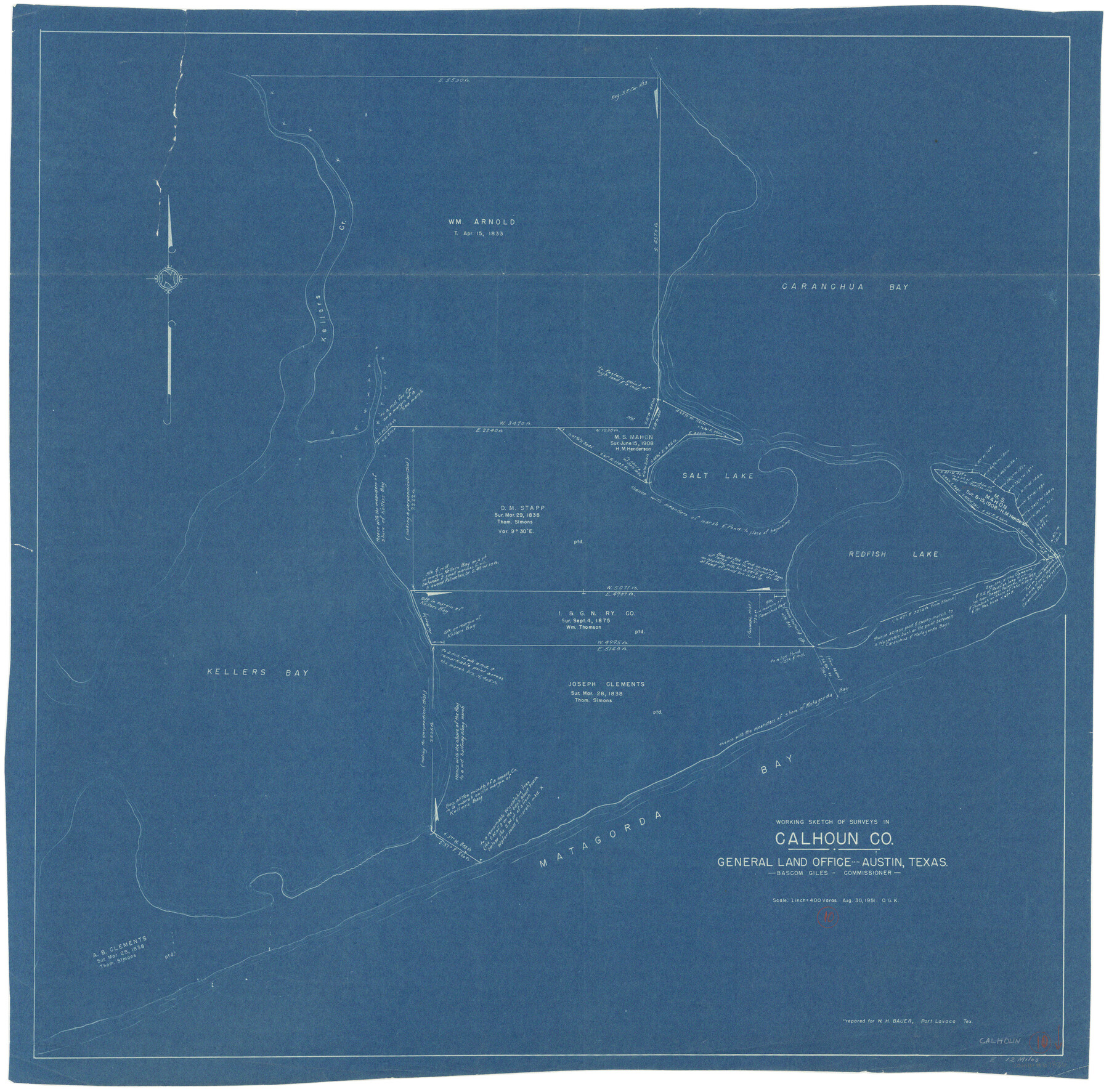
Calhoun County Working Sketch 10
-
Map/Doc
67826
-
Collection
General Map Collection
-
Object Dates
8/30/1951 (Creation Date)
-
People and Organizations
Otto G. Kurio (Draftsman)
-
Counties
Calhoun
-
Subjects
Surveying Working Sketch
-
Height x Width
36.8 x 37.2 inches
93.5 x 94.5 cm
-
Scale
1" = 400 varas
Part of: General Map Collection
Burnet County Sketch File 28

Print $8.00
- Digital $50.00
Burnet County Sketch File 28
1874
Size 12.8 x 8.5 inches
Map/Doc 16740
Trinity County Sketch File 26

Print $8.00
- Digital $50.00
Trinity County Sketch File 26
1885
Size 13.1 x 8.4 inches
Map/Doc 38558
Runnels County Working Sketch 25

Print $20.00
- Digital $50.00
Runnels County Working Sketch 25
1955
Size 38.2 x 47.1 inches
Map/Doc 63621
Hardeman County

Print $20.00
- Digital $50.00
Hardeman County
1876
Size 24.1 x 31.5 inches
Map/Doc 3625
Castro County Sketch File 16

Print $4.00
- Digital $50.00
Castro County Sketch File 16
1891
Size 11.0 x 8.8 inches
Map/Doc 17513
Red River County Working Sketch 22

Print $20.00
- Digital $50.00
Red River County Working Sketch 22
1955
Size 27.9 x 26.8 inches
Map/Doc 72005
Hudspeth County Sketch File 1

Print $8.00
- Digital $50.00
Hudspeth County Sketch File 1
1900
Size 11.3 x 8.8 inches
Map/Doc 26880
Flight Mission No. DAG-21K, Frame 33, Matagorda County

Print $20.00
- Digital $50.00
Flight Mission No. DAG-21K, Frame 33, Matagorda County
1952
Size 18.5 x 22.3 inches
Map/Doc 86400
Uvalde County Working Sketch 29

Print $20.00
- Digital $50.00
Uvalde County Working Sketch 29
1958
Size 25.3 x 41.0 inches
Map/Doc 72099
Webb County Sketch File 59

Print $8.00
- Digital $50.00
Webb County Sketch File 59
1943
Size 14.4 x 9.0 inches
Map/Doc 39851
Burnet County Rolled Sketch 8

Print $40.00
- Digital $50.00
Burnet County Rolled Sketch 8
1971
Size 36.9 x 49.9 inches
Map/Doc 8554
Liberty County

Print $20.00
- Digital $50.00
Liberty County
1862
Size 24.3 x 24.8 inches
Map/Doc 3815
You may also like
Bastrop County Working Sketch Graphic Index

Print $40.00
- Digital $50.00
Bastrop County Working Sketch Graphic Index
1955
Size 49.6 x 40.9 inches
Map/Doc 76462
North Sulphur River, Ben Franklin Sheet

Print $40.00
- Digital $50.00
North Sulphur River, Ben Franklin Sheet
1928
Size 24.6 x 57.4 inches
Map/Doc 65172
[Blocks Y2 and I]
![91261, [Blocks Y2 and I], Twichell Survey Records](https://historictexasmaps.com/wmedia_w700/maps/91261-1.tif.jpg)
Print $20.00
- Digital $50.00
[Blocks Y2 and I]
Size 17.8 x 13.8 inches
Map/Doc 91261
Tarrant County Sketch File 17

Print $8.00
- Digital $50.00
Tarrant County Sketch File 17
1860
Size 8.3 x 8.1 inches
Map/Doc 37716
La Salle County Sketch File 5

Print $2.00
- Digital $50.00
La Salle County Sketch File 5
Size 6.9 x 8.9 inches
Map/Doc 29452
[Leagues 218, 219, 226, 222, 223, 228, and 229]
![91442, [Leagues 218, 219, 226, 222, 223, 228, and 229], Twichell Survey Records](https://historictexasmaps.com/wmedia_w700/maps/91442-1.tif.jpg)
Print $3.00
- Digital $50.00
[Leagues 218, 219, 226, 222, 223, 228, and 229]
1898
Size 9.4 x 14.8 inches
Map/Doc 91442
Terry County Working Sketch 1

Print $20.00
- Digital $50.00
Terry County Working Sketch 1
1938
Size 24.0 x 19.9 inches
Map/Doc 62106
Sutton County Rolled Sketch 52

Print $20.00
- Digital $50.00
Sutton County Rolled Sketch 52
1950
Size 20.8 x 35.2 inches
Map/Doc 7892

[Pecos and Northern Texas Ry., Bailey Co., from Parmer Co. line through Lariat and Muleshoe to Lamb Co. line]
![64635, [Pecos and Northern Texas Ry., Bailey Co., from Parmer Co. line through Lariat and Muleshoe to Lamb Co. line], General Map Collection](https://historictexasmaps.com/wmedia_w700/maps/64635.tif.jpg)
Print $40.00
- Digital $50.00
[Pecos and Northern Texas Ry., Bailey Co., from Parmer Co. line through Lariat and Muleshoe to Lamb Co. line]
1912
Size 19.5 x 121.6 inches
Map/Doc 64635
Duval County Rolled Sketch 30A

Print $40.00
- Digital $50.00
Duval County Rolled Sketch 30A
1896
Size 59.7 x 40.8 inches
Map/Doc 76145
Navigation Maps of Gulf Intracoastal Waterway, Port Arthur to Brownsville, Texas

Print $4.00
- Digital $50.00
Navigation Maps of Gulf Intracoastal Waterway, Port Arthur to Brownsville, Texas
1951
Size 16.6 x 21.3 inches
Map/Doc 65431