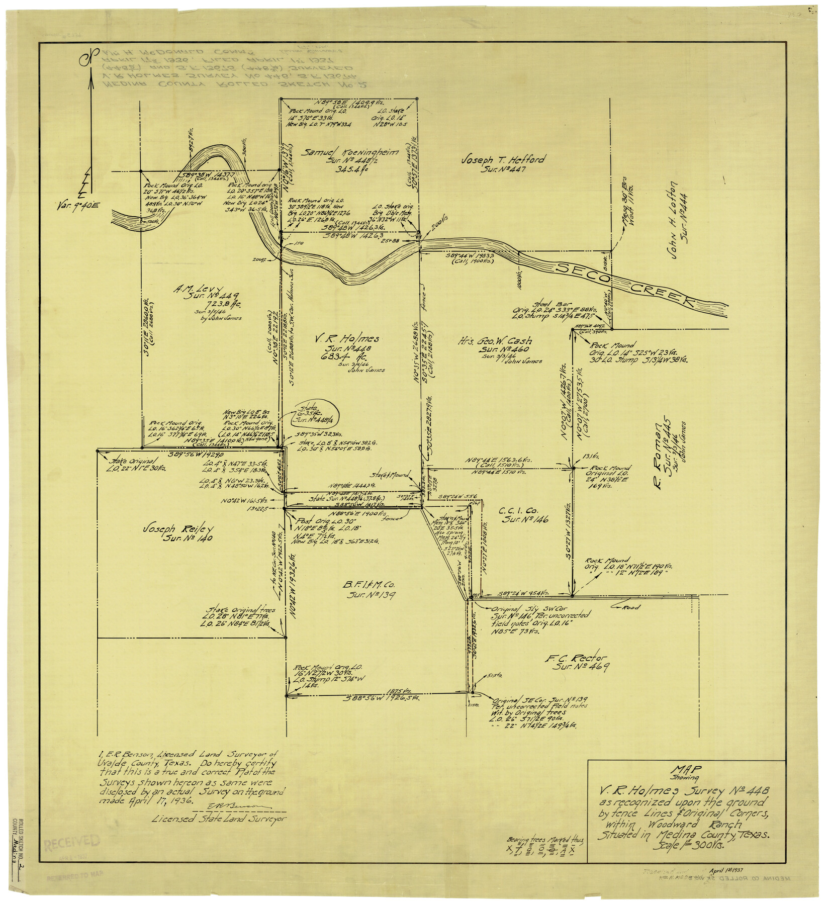
Medina County Rolled Sketch 2
Map showing V.R. Holmes survey no. 448 as recognized upon the ground by fence lines & original corners, within Woodward Ranch situated in Medina County, Texas
-
Map/Doc
6739
-
Collection
General Map Collection
-
Object Dates
4/17/1936 (Creation Date)
4/1/1937 (File Date)
-
People and Organizations
E.R. Benson (Surveyor/Engineer)
-
Counties
Medina
-
Subjects
Surveying Rolled Sketch
-
Height x Width
31.3 x 28.6 inches
79.5 x 72.6 cm
-
Medium
linen, manuscript
-
Scale
1" = 300 varas
Part of: General Map Collection
Freestone County Sketch File 2

Print $12.00
- Digital $50.00
Freestone County Sketch File 2
1849
Size 13.0 x 8.1 inches
Map/Doc 23037
El Paso County Working Sketch 24

Print $20.00
- Digital $50.00
El Paso County Working Sketch 24
1961
Size 26.4 x 22.0 inches
Map/Doc 69046
Matagorda County Rolled Sketch 16

Print $20.00
- Digital $50.00
Matagorda County Rolled Sketch 16
Size 25.7 x 41.6 inches
Map/Doc 7591
Callahan County

Print $20.00
- Digital $50.00
Callahan County
1918
Size 44.6 x 40.2 inches
Map/Doc 4900
[Maps of surveys in Reeves & Culberson Cos]
![61129, [Maps of surveys in Reeves & Culberson Cos], General Map Collection](https://historictexasmaps.com/wmedia_w700/maps/61129.tif.jpg)
Print $20.00
- Digital $50.00
[Maps of surveys in Reeves & Culberson Cos]
1937
Size 30.7 x 25.0 inches
Map/Doc 61129
Clason's Guide Map of Texas

Print $20.00
- Digital $50.00
Clason's Guide Map of Texas
1919
Size 22.4 x 24.5 inches
Map/Doc 97157
Hutchinson County Working Sketch 12

Print $20.00
- Digital $50.00
Hutchinson County Working Sketch 12
1925
Size 20.6 x 29.9 inches
Map/Doc 66370
Cooke County Sketch File 21

Print $4.00
- Digital $50.00
Cooke County Sketch File 21
Size 9.0 x 6.7 inches
Map/Doc 19265
Kimble County Sketch File 17

Print $17.00
- Digital $50.00
Kimble County Sketch File 17
Size 11.5 x 8.5 inches
Map/Doc 28947
Harris County Sketch File 53

Print $20.00
- Digital $50.00
Harris County Sketch File 53
1914
Size 15.9 x 12.0 inches
Map/Doc 11654
Mills County Boundary File 4

Print $40.00
- Digital $50.00
Mills County Boundary File 4
Size 52.1 x 13.3 inches
Map/Doc 57293
Red River County Working Sketch 29

Print $20.00
- Digital $50.00
Red River County Working Sketch 29
1961
Size 29.5 x 33.3 inches
Map/Doc 72012
You may also like
Stonewall County Working Sketch 2

Print $20.00
- Digital $50.00
Stonewall County Working Sketch 2
1915
Size 22.7 x 15.2 inches
Map/Doc 63996
Flight Mission No. BRA-7M, Frame 181, Jefferson County

Print $20.00
- Digital $50.00
Flight Mission No. BRA-7M, Frame 181, Jefferson County
1953
Size 18.6 x 22.4 inches
Map/Doc 85549
McLennan County Sketch File 31

Print $22.00
- Digital $50.00
McLennan County Sketch File 31
Size 14.2 x 17.2 inches
Map/Doc 31306
Pecos County Sketch File 111

Print $18.00
- Digital $50.00
Pecos County Sketch File 111
Size 13.3 x 8.8 inches
Map/Doc 34052
Travels to the source of the Missouri River and across the American Continent to the Pacific Ocean - Vol. 2

Travels to the source of the Missouri River and across the American Continent to the Pacific Ocean - Vol. 2
1815
Map/Doc 97413
Reeves County Working Sketch 44

Print $20.00
- Digital $50.00
Reeves County Working Sketch 44
1974
Size 46.9 x 32.1 inches
Map/Doc 63487
Mitchell County Sketch File 15

Print $20.00
- Digital $50.00
Mitchell County Sketch File 15
1931
Size 19.2 x 19.6 inches
Map/Doc 12102
Flight Mission No. DQN-7K, Frame 94, Calhoun County

Print $20.00
- Digital $50.00
Flight Mission No. DQN-7K, Frame 94, Calhoun County
1953
Size 18.6 x 22.1 inches
Map/Doc 84485
Uvalde County Working Sketch 16

Print $20.00
- Digital $50.00
Uvalde County Working Sketch 16
1946
Size 37.0 x 27.2 inches
Map/Doc 72086
Sectional Map No. 3 of the lands and of the line of the Texas & Pacific Ry. Co. in Reeves and parts of Tom Green, Pecos, Presidio & El Paso Cos.

Print $20.00
- Digital $50.00
Sectional Map No. 3 of the lands and of the line of the Texas & Pacific Ry. Co. in Reeves and parts of Tom Green, Pecos, Presidio & El Paso Cos.
1885
Size 22.3 x 17.4 inches
Map/Doc 2303
Hamilton County Working Sketch 4

Print $20.00
- Digital $50.00
Hamilton County Working Sketch 4
1935
Size 32.6 x 36.9 inches
Map/Doc 63342
Upton County Working Sketch 40

Print $40.00
- Digital $50.00
Upton County Working Sketch 40
1959
Size 37.5 x 63.7 inches
Map/Doc 69536