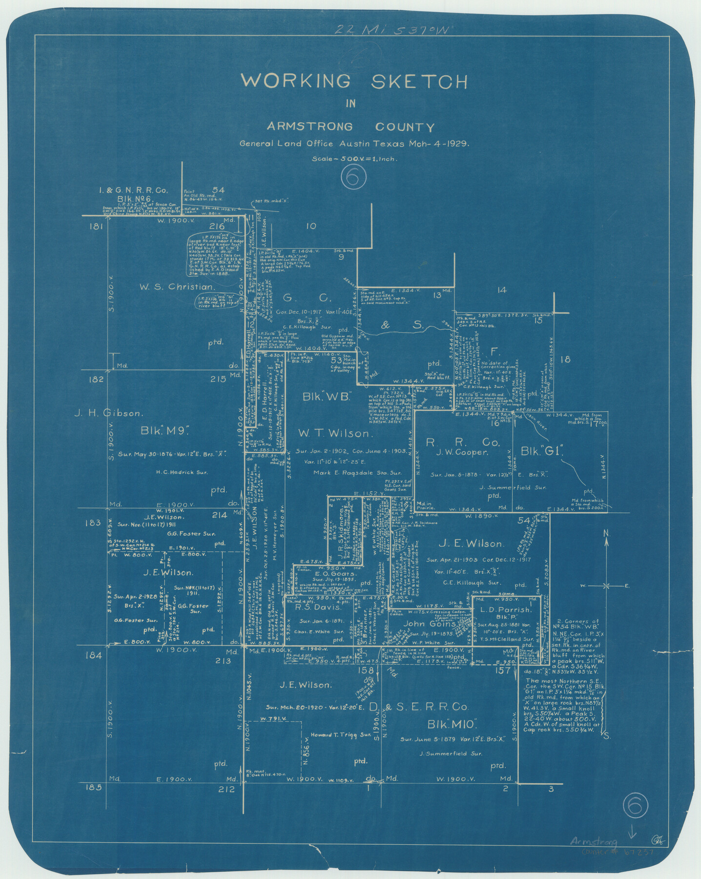
Armstrong County Working Sketch 6
-
Map/Doc
67237
-
Collection
General Map Collection
-
Object Dates
3/4/1929 (Creation Date)
-
Counties
Armstrong
-
Subjects
Surveying Working Sketch
-
Height x Width
24.3 x 19.4 inches
61.7 x 49.3 cm
-
Scale
1" = 500 varas
-
Comments
Surveys located about 22 miles South 37 degrees West of Claude, Texas.
Part of: General Map Collection
Starr County Sketch File 4

Print $3.00
- Digital $50.00
Starr County Sketch File 4
Size 9.3 x 11.5 inches
Map/Doc 36857

Nautical Chart 885-SC Intracoastal Waterway - Ellender to Galveston Bay, Louisiana-Texas

Print $40.00
- Digital $50.00
Nautical Chart 885-SC Intracoastal Waterway - Ellender to Galveston Bay, Louisiana-Texas
1972
Size 16.1 x 59.4 inches
Map/Doc 69836
Mason County Working Sketch 7

Print $20.00
- Digital $50.00
Mason County Working Sketch 7
1945
Size 35.8 x 43.9 inches
Map/Doc 70843
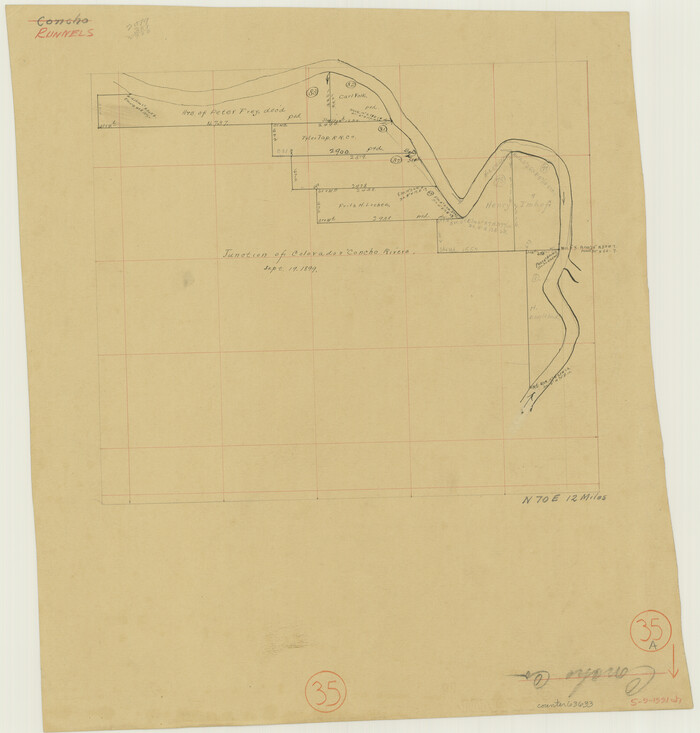
Runnels County Working Sketch 35a
Print $20.00
- Digital $50.00
Runnels County Working Sketch 35a
Size 14.9 x 14.2 inches
Map/Doc 63633
Crosby County Sketch File 27

Print $20.00
- Digital $50.00
Crosby County Sketch File 27
Size 8.8 x 23.0 inches
Map/Doc 11256
Cameron County NRC Article 33.136 Location Key Sheet

Print $20.00
- Digital $50.00
Cameron County NRC Article 33.136 Location Key Sheet
1983
Size 27.0 x 22.0 inches
Map/Doc 77012
Flight Mission No. BRA-17M, Frame 13, Jefferson County

Print $20.00
- Digital $50.00
Flight Mission No. BRA-17M, Frame 13, Jefferson County
1953
Size 18.6 x 22.3 inches
Map/Doc 85794
Dallas County Boundary File 5a

Print $4.00
- Digital $50.00
Dallas County Boundary File 5a
Size 4.9 x 8.6 inches
Map/Doc 52182
Presidio County Working Sketch 23

Print $20.00
- Digital $50.00
Presidio County Working Sketch 23
1945
Size 35.7 x 23.3 inches
Map/Doc 71699
Angelina River, Mud Creek, Sheet 2

Print $4.00
- Digital $50.00
Angelina River, Mud Creek, Sheet 2
1937
Size 26.4 x 18.9 inches
Map/Doc 65076
Dimmit County Sketch File 61

Print $12.00
- Digital $50.00
Dimmit County Sketch File 61
1999
Size 11.4 x 8.8 inches
Map/Doc 21208
You may also like
A Survey of Lake Champlain, including Lake George, Crown Point and St. John

Print $20.00
- Digital $50.00
A Survey of Lake Champlain, including Lake George, Crown Point and St. John
1762
Size 29.0 x 20.9 inches
Map/Doc 97404
Sabine Pass and Lake

Print $20.00
- Digital $50.00
Sabine Pass and Lake
1971
Size 47.0 x 27.5 inches
Map/Doc 69825
Travis County Rolled Sketch 28

Print $20.00
- Digital $50.00
Travis County Rolled Sketch 28
1941
Size 22.7 x 27.0 inches
Map/Doc 8030
[Randall County School Land League 152 and vicinity]
![92999, [Randall County School Land League 152 and vicinity], Twichell Survey Records](https://historictexasmaps.com/wmedia_w700/maps/92999-1.tif.jpg)
Print $2.00
- Digital $50.00
[Randall County School Land League 152 and vicinity]
1949
Size 5.8 x 7.5 inches
Map/Doc 92999
Harris County Rolled Sketch 85

Print $20.00
- Digital $50.00
Harris County Rolled Sketch 85
1968
Size 22.0 x 32.0 inches
Map/Doc 6119
Flight Mission No. CUG-2P, Frame 8, Kleberg County

Print $20.00
- Digital $50.00
Flight Mission No. CUG-2P, Frame 8, Kleberg County
1956
Size 18.5 x 22.2 inches
Map/Doc 86180
Hockley County Sketch File 6

Print $20.00
- Digital $50.00
Hockley County Sketch File 6
Size 24.9 x 33.0 inches
Map/Doc 11769
Crockett County Sketch File 21

Print $18.00
- Digital $50.00
Crockett County Sketch File 21
Size 13.6 x 8.4 inches
Map/Doc 19682
Flight Mission No. DCL-7C, Frame 137, Kenedy County

Print $20.00
- Digital $50.00
Flight Mission No. DCL-7C, Frame 137, Kenedy County
1943
Size 15.4 x 15.3 inches
Map/Doc 86094
Portion of Lands in Parmer County, Texas Owned and For Sale by Capitol Freehold Land and Investment Co., Ltd.

Print $3.00
- Digital $50.00
Portion of Lands in Parmer County, Texas Owned and For Sale by Capitol Freehold Land and Investment Co., Ltd.
Size 16.7 x 11.3 inches
Map/Doc 91550
Terrell County Working Sketch 4

Print $20.00
- Digital $50.00
Terrell County Working Sketch 4
1914
Size 22.1 x 22.3 inches
Map/Doc 62153
Flight Mission No. CGI-1N, Frame 169, Cameron County

Print $20.00
- Digital $50.00
Flight Mission No. CGI-1N, Frame 169, Cameron County
1955
Size 18.6 x 22.2 inches
Map/Doc 84504