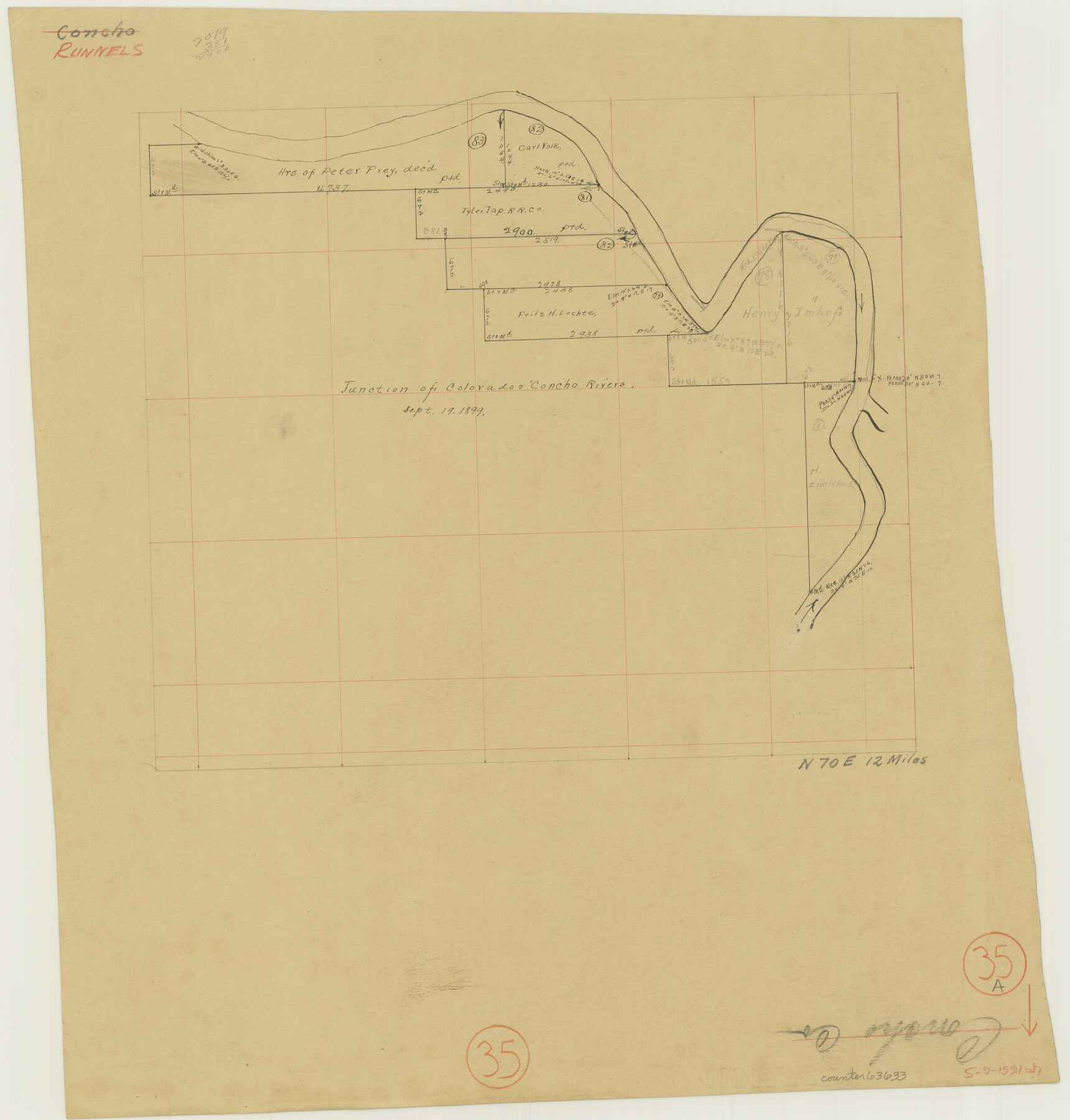
Runnels County Working Sketch 35a
-
Map/Doc
63633
-
Collection
General Map Collection
-
Counties
Runnels
-
Subjects
Surveying Working Sketch
-
Height x Width
14.9 x 14.2 inches
37.9 x 36.1 cm
Part of: General Map Collection
Flight Mission No. CRC-2R, Frame 5, Chambers County

Print $20.00
- Digital $50.00
Flight Mission No. CRC-2R, Frame 5, Chambers County
1956
Size 18.7 x 22.4 inches
Map/Doc 84724
Flight Mission No. BRA-16M, Frame 93, Jefferson County

Print $20.00
- Digital $50.00
Flight Mission No. BRA-16M, Frame 93, Jefferson County
1953
Size 18.5 x 22.4 inches
Map/Doc 85705
Fort Bend County Working Sketch 13

Print $20.00
- Digital $50.00
Fort Bend County Working Sketch 13
1946
Size 29.0 x 29.3 inches
Map/Doc 69218
Presidio County

Print $40.00
- Digital $50.00
Presidio County
1875
Size 98.1 x 36.4 inches
Map/Doc 88866
Tyler County Working Sketch 15

Print $20.00
- Digital $50.00
Tyler County Working Sketch 15
1960
Size 23.8 x 18.1 inches
Map/Doc 69485
Crockett County Working Sketch 66

Print $40.00
- Digital $50.00
Crockett County Working Sketch 66
1959
Size 62.7 x 44.0 inches
Map/Doc 68399
Van Zandt County Sketch File 35

Print $4.00
- Digital $50.00
Van Zandt County Sketch File 35
1862
Size 12.7 x 8.2 inches
Map/Doc 39474
Pecos County Rolled Sketch 25B

Print $20.00
- Digital $50.00
Pecos County Rolled Sketch 25B
1892
Size 22.2 x 16.0 inches
Map/Doc 7210
Galveston County NRC Article 33.136 Location Key Sheet

Print $20.00
- Digital $50.00
Galveston County NRC Article 33.136 Location Key Sheet
1994
Size 27.0 x 21.8 inches
Map/Doc 77016
San Jacinto County Sketch File 21

Print $2.00
San Jacinto County Sketch File 21
1873
Size 10.4 x 8.4 inches
Map/Doc 35802
Sutton County Working Sketch 66

Print $20.00
- Digital $50.00
Sutton County Working Sketch 66
1972
Size 29.0 x 39.3 inches
Map/Doc 62409
Controlled Mosaic by Jack Amman Photogrammetric Engineers, Inc - Sheet 20

Print $20.00
- Digital $50.00
Controlled Mosaic by Jack Amman Photogrammetric Engineers, Inc - Sheet 20
1954
Size 20.0 x 24.0 inches
Map/Doc 83468
You may also like
Brewster County Rolled Sketch 144A

Print $40.00
- Digital $50.00
Brewster County Rolled Sketch 144A
Size 53.4 x 43.5 inches
Map/Doc 9195
Brewster County Rolled Sketch 108

Print $20.00
- Digital $50.00
Brewster County Rolled Sketch 108
1958
Size 29.8 x 17.1 inches
Map/Doc 5260
Hudspeth County Sketch File 28

Print $20.00
- Digital $50.00
Hudspeth County Sketch File 28
1943
Size 15.3 x 21.4 inches
Map/Doc 11803
Sketch File C, Lamb County

Print $20.00
- Digital $50.00
Sketch File C, Lamb County
1904
Size 21.6 x 26.0 inches
Map/Doc 91069
Supreme Court of the United States, October Term, 1924, No. 13, Original - The State of Oklahoma, Complainant vs. The State of Texas, Defendant, The United States, Intervener

Print $20.00
- Digital $50.00
Supreme Court of the United States, October Term, 1924, No. 13, Original - The State of Oklahoma, Complainant vs. The State of Texas, Defendant, The United States, Intervener
1924
Size 19.5 x 32.6 inches
Map/Doc 75112
Llano County Sketch File 6

Print $8.00
- Digital $50.00
Llano County Sketch File 6
1877
Size 9.4 x 7.9 inches
Map/Doc 30358
[C.C.S.D. & R.G.N.G. RR. Co. Blk. G east thru T.&P. Blk 33]
![89775, [C.C.S.D. & R.G.N.G. RR. Co. Blk. G east thru T.&P. Blk 33], Twichell Survey Records](https://historictexasmaps.com/wmedia_w700/maps/89775-1.tif.jpg)
Print $40.00
- Digital $50.00
[C.C.S.D. & R.G.N.G. RR. Co. Blk. G east thru T.&P. Blk 33]
1901
Size 70.2 x 23.0 inches
Map/Doc 89775
Bowie County Working Sketch 5

Print $20.00
- Digital $50.00
Bowie County Working Sketch 5
1927
Size 22.8 x 26.6 inches
Map/Doc 67409
[C. C. Slaughter Block 1, T. T. RR. Co. Block 2]
![90621, [C. C. Slaughter Block 1, T. T. RR. Co. Block 2], Twichell Survey Records](https://historictexasmaps.com/wmedia_w700/maps/90621-1.tif.jpg)
Print $2.00
- Digital $50.00
[C. C. Slaughter Block 1, T. T. RR. Co. Block 2]
Size 8.6 x 11.5 inches
Map/Doc 90621
Liberty County Working Sketch 27

Print $20.00
- Digital $50.00
Liberty County Working Sketch 27
1942
Size 22.1 x 25.2 inches
Map/Doc 70486
Colorado County Sketch File 25

Print $8.00
- Digital $50.00
Colorado County Sketch File 25
1919
Size 11.5 x 8.8 inches
Map/Doc 18963
Culberson County Rolled Sketch 52

Print $20.00
- Digital $50.00
Culberson County Rolled Sketch 52
Size 18.7 x 24.8 inches
Map/Doc 5675