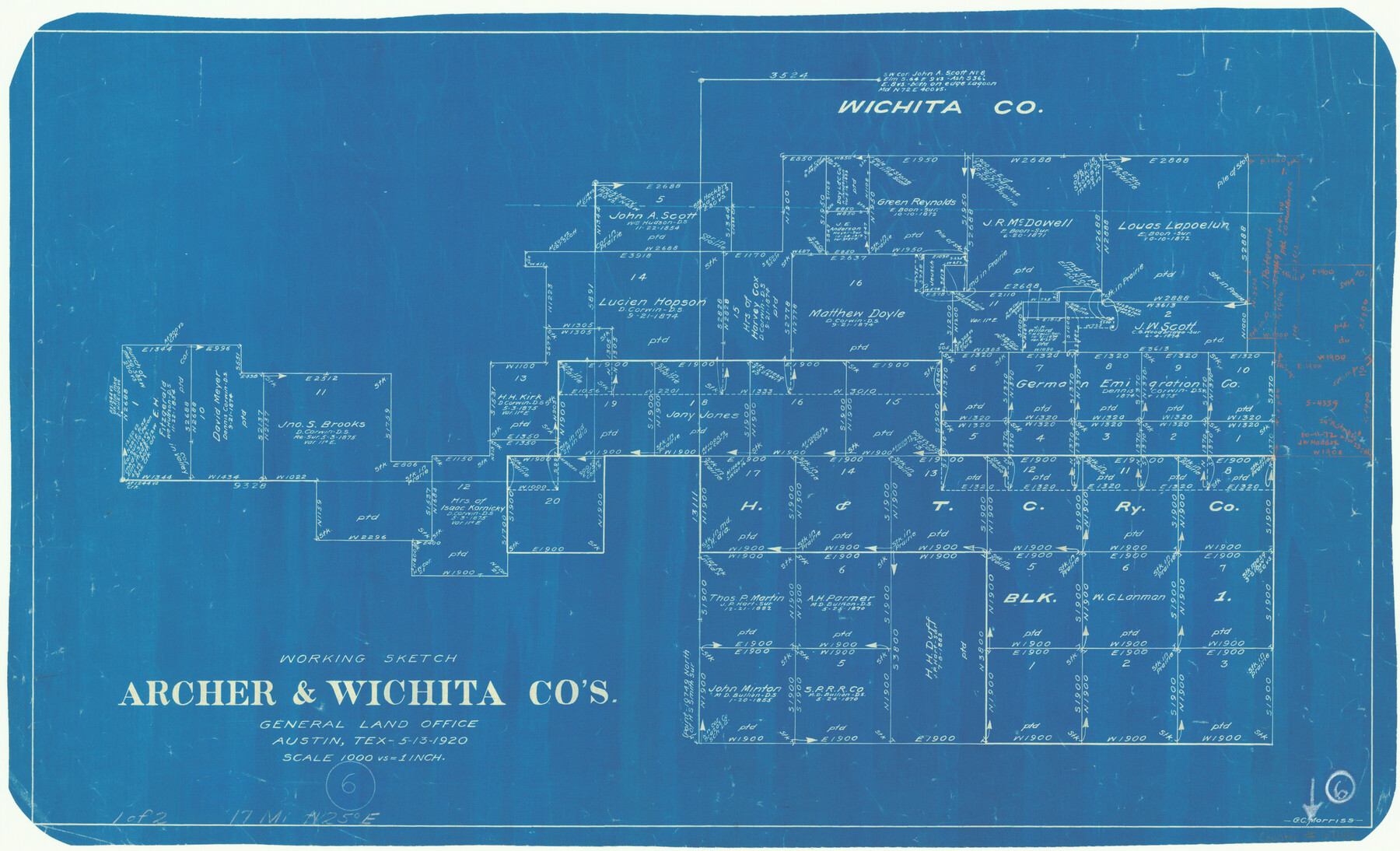
Archer County Working Sketch 6
-
Map/Doc
67146
-
Collection
General Map Collection
-
Object Dates
5/13/1920 (Creation Date)
-
People and Organizations
G.C. Morriss (Draftsman)
-
Counties
Archer Wichita
-
Subjects
Surveying Working Sketch
-
Height x Width
16.9 x 27.7 inches
42.9 x 70.4 cm
-
Scale
1" = 1000 varas
-
Comments
Surveys located about 17 miles North 25 degrees East of Archer City, Texas.
Part of: General Map Collection
Val Verde Co.

Print $20.00
- Digital $50.00
Val Verde Co.
1908
Size 40.9 x 38.5 inches
Map/Doc 63101
Le Vieux Mexique ou Nouvelle Espagne avec les costes de la Floride faisant partie de l'Amerique Septentrionale

Print $20.00
- Digital $50.00
Le Vieux Mexique ou Nouvelle Espagne avec les costes de la Floride faisant partie de l'Amerique Septentrionale
1702
Size 11.2 x 15.5 inches
Map/Doc 95922
Cass County Sketch File 9

Print $4.00
- Digital $50.00
Cass County Sketch File 9
1857
Size 8.0 x 13.1 inches
Map/Doc 17410
Reagan County Boundary File 2

Print $20.00
- Digital $50.00
Reagan County Boundary File 2
Size 17.5 x 32.4 inches
Map/Doc 58190
Duval County Rolled Sketch EF

Print $20.00
- Digital $50.00
Duval County Rolled Sketch EF
1934
Size 26.8 x 35.0 inches
Map/Doc 5766
Freestone County Sketch File 5

Print $42.00
- Digital $50.00
Freestone County Sketch File 5
1854
Size 4.6 x 5.2 inches
Map/Doc 23047
Tarrant County

Print $20.00
- Digital $50.00
Tarrant County
1942
Size 46.5 x 37.1 inches
Map/Doc 77431
Flight Mission No. CZW-1R, Frame 116, Hardeman County

Print $20.00
- Digital $50.00
Flight Mission No. CZW-1R, Frame 116, Hardeman County
1956
Size 18.6 x 19.0 inches
Map/Doc 85235
Brewster County Sketch File NS-9

Print $40.00
- Digital $50.00
Brewster County Sketch File NS-9
1944
Size 14.2 x 8.9 inches
Map/Doc 16135
Flight Mission No. DQO-8K, Frame 43, Galveston County

Print $20.00
- Digital $50.00
Flight Mission No. DQO-8K, Frame 43, Galveston County
1952
Size 18.6 x 22.3 inches
Map/Doc 85150
Menard County Boundary File 1a

Print $8.00
- Digital $50.00
Menard County Boundary File 1a
Size 12.7 x 8.2 inches
Map/Doc 57042
Reeves County Rolled Sketch 18

Print $20.00
- Digital $50.00
Reeves County Rolled Sketch 18
1963
Size 23.4 x 27.4 inches
Map/Doc 7487
You may also like
A Map of Lewis and Clark's Track, across the Western Portion of North America from the Mississippi to the Pacific Ocean; by order of the Executive of the United States in 1804, 5 & 6

Print $20.00
- Digital $50.00
A Map of Lewis and Clark's Track, across the Western Portion of North America from the Mississippi to the Pacific Ocean; by order of the Executive of the United States in 1804, 5 & 6
1962
Size 11.5 x 25.1 inches
Map/Doc 97174
Kendall County Working Sketch 18

Print $20.00
- Digital $50.00
Kendall County Working Sketch 18
1970
Size 43.2 x 33.3 inches
Map/Doc 66690
Borden County Sketch File 1a

Print $40.00
- Digital $50.00
Borden County Sketch File 1a
1900
Size 24.6 x 11.7 inches
Map/Doc 10931
Atascosa County Working Sketch 34

Print $20.00
- Digital $50.00
Atascosa County Working Sketch 34
1958
Size 13.3 x 25.5 inches
Map/Doc 67230
Culberson County Rolled Sketch X1

Print $20.00
- Digital $50.00
Culberson County Rolled Sketch X1
1896
Size 20.1 x 20.1 inches
Map/Doc 5684

Liberty County Working Sketch 21

Print $20.00
- Digital $50.00
Liberty County Working Sketch 21
1940
Size 20.1 x 15.0 inches
Map/Doc 70480
The Republic County of Bexar. Proposed, Late Fall 1837

Print $20.00
The Republic County of Bexar. Proposed, Late Fall 1837
2020
Size 24.6 x 21.6 inches
Map/Doc 96093
Mason County Sketch File 22

Print $8.00
- Digital $50.00
Mason County Sketch File 22
1932
Size 11.1 x 8.9 inches
Map/Doc 30719
Nolan County Sketch File 11

Print $20.00
- Digital $50.00
Nolan County Sketch File 11
1902
Size 18.5 x 37.5 inches
Map/Doc 42162
Flight Mission No. CRC-5R, Frame 38, Chambers County

Print $20.00
- Digital $50.00
Flight Mission No. CRC-5R, Frame 38, Chambers County
1956
Size 18.6 x 22.3 inches
Map/Doc 84957
McLennan County Sketch File 41

Print $44.00
- Digital $50.00
McLennan County Sketch File 41
1963
Size 11.1 x 8.6 inches
Map/Doc 31319