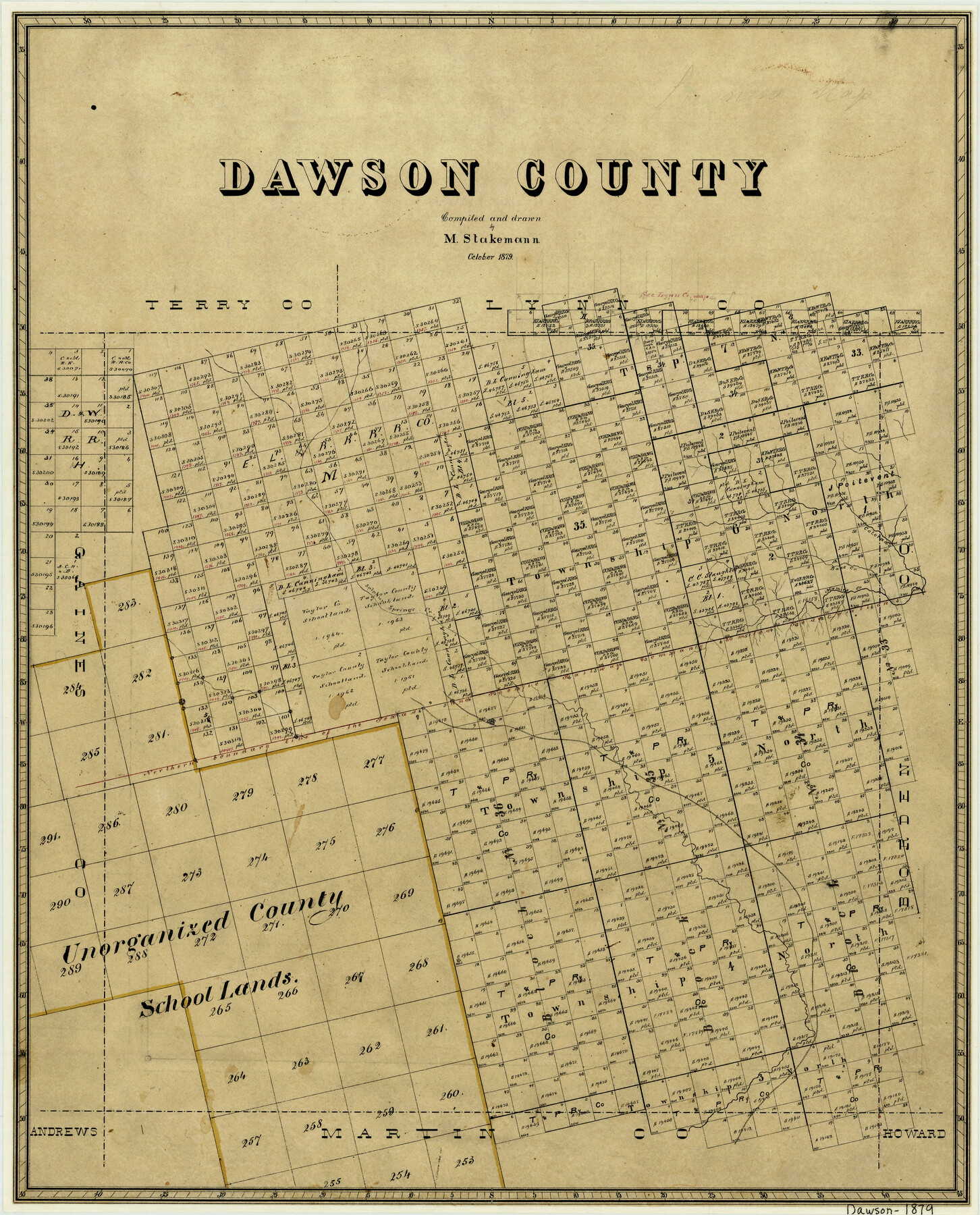
Dawson County
-
Map/Doc
3468
-
Collection
General Map Collection
-
Object Dates
10/1879 (Creation Date)
-
People and Organizations
Max Stakemann (Draftsman)
-
Counties
Dawson
-
Subjects
County
-
Height x Width
22.1 x 17.8 inches
56.1 x 45.2 cm
-
Comments
Adopted and conserved by LaNell H. Aston and Susan Smith Dorsey in memory of Spencer L. Reid - our mentor, dear friend and co-worker. Austin, Texas, 2013.
-
Features
Colorado River
Mamie's Creek
Sulphur Springs Creek
Part of: General Map Collection
Texas State Boundary Line 5

Print $48.00
- Digital $50.00
Texas State Boundary Line 5
1907
Size 12.4 x 21.1 inches
Map/Doc 74959
Brazoria County NRC Article 33.136 Sketch 30

Print $24.00
Brazoria County NRC Article 33.136 Sketch 30
2025
Map/Doc 97475
A new and accurate map of North America (wherein the errors of all preceeding British, French and Dutch maps, respecting the rights of Great Britain, France & Spain, & the limits of each of His Majesty's provinces, are corrected)

Print $20.00
- Digital $50.00
A new and accurate map of North America (wherein the errors of all preceeding British, French and Dutch maps, respecting the rights of Great Britain, France & Spain, & the limits of each of His Majesty's provinces, are corrected)
1755
Size 18.3 x 22.1 inches
Map/Doc 97416
Brewster County Rolled Sketch 91

Print $20.00
- Digital $50.00
Brewster County Rolled Sketch 91
1949
Size 27.5 x 15.3 inches
Map/Doc 5249
No. IX - Outline map of the vicinity of Corpus Christi

Print $20.00
- Digital $50.00
No. IX - Outline map of the vicinity of Corpus Christi
Size 24.8 x 18.3 inches
Map/Doc 72967
Oldham County Sketch File 8

Print $4.00
- Digital $50.00
Oldham County Sketch File 8
Size 7.9 x 11.9 inches
Map/Doc 33239
San Augustine County Rolled Sketch 1

Print $20.00
- Digital $50.00
San Augustine County Rolled Sketch 1
1946
Size 19.1 x 30.4 inches
Map/Doc 7553
Bailey County

Print $40.00
- Digital $50.00
Bailey County
1956
Size 49.4 x 31.4 inches
Map/Doc 95423

Kimble County Working Sketch 20

Print $20.00
- Digital $50.00
Kimble County Working Sketch 20
1929
Size 36.2 x 27.8 inches
Map/Doc 70088
Coleman County Rolled Sketch 7

Print $20.00
- Digital $50.00
Coleman County Rolled Sketch 7
Size 19.3 x 14.3 inches
Map/Doc 5530
Rusk County Sketch File 38

Print $6.00
Rusk County Sketch File 38
1951
Size 11.3 x 8.8 inches
Map/Doc 35576
You may also like
Leon County Rolled Sketch 35

Print $20.00
- Digital $50.00
Leon County Rolled Sketch 35
2018
Size 30.7 x 21.3 inches
Map/Doc 95288
Throckmorton County Sketch File 5a

Print $22.00
- Digital $50.00
Throckmorton County Sketch File 5a
Size 8.0 x 7.8 inches
Map/Doc 38075
Hartley County Sketch File 3

Print $20.00
- Digital $50.00
Hartley County Sketch File 3
1883
Size 26.8 x 38.4 inches
Map/Doc 10489
Flight Mission No. DAH-17M, Frame 22, Orange County

Print $20.00
- Digital $50.00
Flight Mission No. DAH-17M, Frame 22, Orange County
1953
Size 18.8 x 22.6 inches
Map/Doc 86885
Real County Sketch File 16

Print $20.00
- Digital $50.00
Real County Sketch File 16
1934
Size 23.1 x 22.1 inches
Map/Doc 12234
Newton County Rolled Sketch 6A

Digital $50.00
Newton County Rolled Sketch 6A
Size 10.3 x 15.4 inches
Map/Doc 46838

United States Atlantic and Gulf Coasts Including Puerto Rico and the Virgin Islands

Print $40.00
- Digital $50.00
United States Atlantic and Gulf Coasts Including Puerto Rico and the Virgin Islands
1989
Size 21.4 x 60.4 inches
Map/Doc 73552
Fisher County Sketch File 15a

Print $10.00
- Digital $50.00
Fisher County Sketch File 15a
1901
Size 7.6 x 9.0 inches
Map/Doc 22578
Potter County Rolled Sketch 13

Print $20.00
- Digital $50.00
Potter County Rolled Sketch 13
2004
Size 19.2 x 23.2 inches
Map/Doc 82479
Trinity River, OwenCrossing Sheet/Elm Fork of Trinity River

Print $20.00
- Digital $50.00
Trinity River, OwenCrossing Sheet/Elm Fork of Trinity River
1914
Size 29.2 x 29.4 inches
Map/Doc 78340
