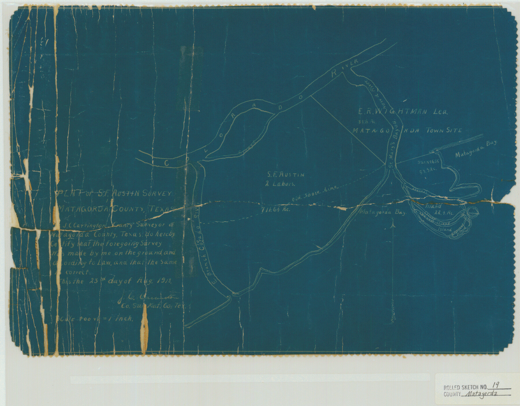
Matagorda County Rolled Sketch 19
Plat of S.F. Austin survey, Matagorda County, Texas
-
Map/Doc
6687
-
Collection
General Map Collection
-
Object Dates
1918/8/23 (Creation Date)
-
People and Organizations
J.C. Carrington (Surveyor/Engineer)
-
Counties
Matagorda
-
Subjects
Surveying Rolled Sketch
-
Height x Width
13.0 x 16.6 inches
33.0 x 42.2 cm
-
Medium
blueprint/diazo
-
Scale
1" = 400 varas
Part of: General Map Collection

Map of Harris County

Print $40.00
- Digital $50.00
Map of Harris County
1896
Size 52.7 x 66.7 inches
Map/Doc 82071
Baylor County

Print $40.00
- Digital $50.00
Baylor County
1917
Size 48.1 x 40.2 inches
Map/Doc 66714
Flight Mission No. DQO-8K, Frame 10, Galveston County

Print $20.00
- Digital $50.00
Flight Mission No. DQO-8K, Frame 10, Galveston County
1952
Size 18.7 x 22.4 inches
Map/Doc 85133
Stonewall County Working Sketch 35

Print $20.00
- Digital $50.00
Stonewall County Working Sketch 35
1991
Size 41.1 x 33.0 inches
Map/Doc 62342
Callahan County Working Sketch 5

Print $20.00
- Digital $50.00
Callahan County Working Sketch 5
1954
Size 24.3 x 33.8 inches
Map/Doc 67887
El Paso County Sketch File 6

Print $24.00
- Digital $50.00
El Paso County Sketch File 6
Size 13.4 x 8.8 inches
Map/Doc 21958
Borden County Working Sketch 1a and 1b

Print $20.00
- Digital $50.00
Borden County Working Sketch 1a and 1b
1890
Size 16.2 x 18.0 inches
Map/Doc 67461
Garza County Sketch File 4a

Print $4.00
- Digital $50.00
Garza County Sketch File 4a
1883
Size 14.2 x 8.8 inches
Map/Doc 24048
Terrell County Sketch File 33

Print $20.00
- Digital $50.00
Terrell County Sketch File 33
1924
Size 18.2 x 27.6 inches
Map/Doc 12427
Comanche County Sketch File 4

Print $40.00
- Digital $50.00
Comanche County Sketch File 4
1855
Size 19.0 x 15.9 inches
Map/Doc 19057
Oldham County Sketch File 1

Print $24.00
- Digital $50.00
Oldham County Sketch File 1
1880
Size 12.6 x 7.9 inches
Map/Doc 33213
You may also like
Potter County Working Sketch 9

Print $40.00
- Digital $50.00
Potter County Working Sketch 9
1966
Size 46.4 x 48.6 inches
Map/Doc 71669
Cameron County Rolled Sketch 7

Print $20.00
- Digital $50.00
Cameron County Rolled Sketch 7
1926
Size 27.4 x 31.8 inches
Map/Doc 8563
Montague County Working Sketch 22

Print $20.00
- Digital $50.00
Montague County Working Sketch 22
1952
Size 29.5 x 24.6 inches
Map/Doc 71088
Live Oak County Working Sketch 18

Print $20.00
- Digital $50.00
Live Oak County Working Sketch 18
1961
Size 30.2 x 29.6 inches
Map/Doc 70603
Parker County Sketch File 23

Print $20.00
- Digital $50.00
Parker County Sketch File 23
1876
Size 18.8 x 22.8 inches
Map/Doc 12145
General Highway Map, Glasscock County, Texas

Print $20.00
General Highway Map, Glasscock County, Texas
1961
Size 18.2 x 24.8 inches
Map/Doc 79480
Railroad map of the state of Texas / compiled and engraved expressly for the American railroad manual.

Print $20.00
Railroad map of the state of Texas / compiled and engraved expressly for the American railroad manual.
1873
Size 13.4 x 9.5 inches
Map/Doc 93599
Upton County Working Sketch 48

Print $20.00
- Digital $50.00
Upton County Working Sketch 48
1975
Size 29.3 x 24.3 inches
Map/Doc 69544
[Sketch of Runnels County School Land and vicinity]
![91666, [Sketch of Runnels County School Land and vicinity], Twichell Survey Records](https://historictexasmaps.com/wmedia_w700/maps/91666-1.tif.jpg)
Print $20.00
- Digital $50.00
[Sketch of Runnels County School Land and vicinity]
Size 17.3 x 15.3 inches
Map/Doc 91666
Donley County Sketch File B12

Print $6.00
- Digital $50.00
Donley County Sketch File B12
1982
Size 9.1 x 14.6 inches
Map/Doc 21276
Young County Working Sketch 14

Print $20.00
- Digital $50.00
Young County Working Sketch 14
1944
Size 15.3 x 16.0 inches
Map/Doc 62037
[Notes and map showing Public School Land Block K between Yoakum and Terry Counties]
![92009, [Notes and map showing Public School Land Block K between Yoakum and Terry Counties], Twichell Survey Records](https://historictexasmaps.com/wmedia_w700/maps/92009-1.tif.jpg)
Print $2.00
- Digital $50.00
[Notes and map showing Public School Land Block K between Yoakum and Terry Counties]
Size 8.4 x 5.7 inches
Map/Doc 92009