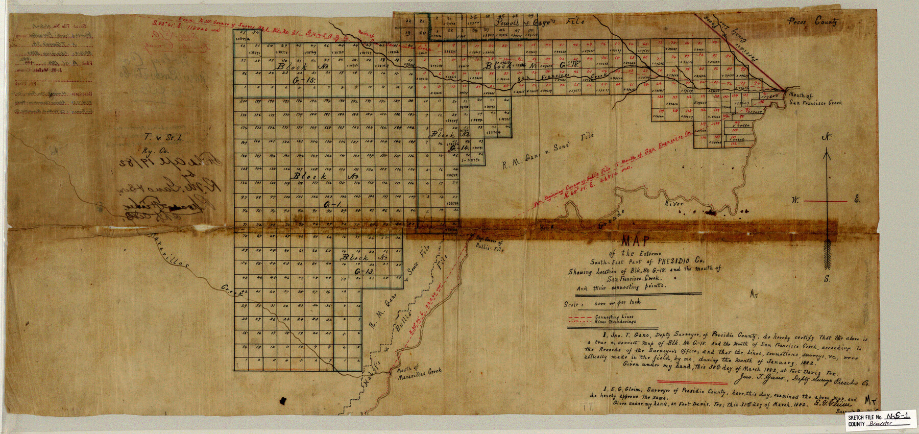
Brewster County Sketch File NS-1
Map of the Extreme South-East Part of Presidio Co. Showing Location of Blk. No. G-18 and the mouth of San Francisco Creek and their connecting points
-
Map/Doc
10985
-
Collection
General Map Collection
-
Object Dates
1882 (Survey Date)
1882/3/30 (Creation Date)
1882/4/19 (File Date)
-
People and Organizations
Jno. T. Gano (Surveyor/Engineer)
-
Counties
Brewster
-
Subjects
Surveying Sketch File
-
Height x Width
14.9 x 31.6 inches
37.8 x 80.3 cm
-
Medium
paper, manuscript
-
Scale
1" = 4000 varas
-
Features
San Francisco Creek
Mouth of San Francisco Creek
Rio Grande
Maravillas Creek
Mouth of Maravillas Creek
Part of: General Map Collection
Robertson County Sketch File 5

Print $6.00
Robertson County Sketch File 5
1863
Size 12.0 x 9.0 inches
Map/Doc 35358
Motley County Sketch File F (S)

Print $14.00
- Digital $50.00
Motley County Sketch File F (S)
1904
Size 9.1 x 5.9 inches
Map/Doc 32179
T. & N. O. R.R. Jefferson Co. North

Print $20.00
- Digital $50.00
T. & N. O. R.R. Jefferson Co. North
1917
Size 13.4 x 33.5 inches
Map/Doc 64058
Estes Quadrangle

Print $20.00
- Digital $50.00
Estes Quadrangle
1971
Size 27.8 x 23.6 inches
Map/Doc 73442
Crockett County Rolled Sketch 99

Print $20.00
- Digital $50.00
Crockett County Rolled Sketch 99
Size 37.2 x 38.2 inches
Map/Doc 95401
Webb County Working Sketch 42

Print $20.00
- Digital $50.00
Webb County Working Sketch 42
1941
Size 12.2 x 16.1 inches
Map/Doc 72407
[San Antonio & Aransas Pass]
![64209, [San Antonio & Aransas Pass], General Map Collection](https://historictexasmaps.com/wmedia_w700/maps/64209.tif.jpg)
Print $20.00
- Digital $50.00
[San Antonio & Aransas Pass]
Size 15.2 x 45.5 inches
Map/Doc 64209
Flight Mission No. BRA-7M, Frame 137, Jefferson County

Print $20.00
- Digital $50.00
Flight Mission No. BRA-7M, Frame 137, Jefferson County
1953
Size 18.7 x 22.4 inches
Map/Doc 85531
Refugio County Aerial Photograph Index Sheet 1

Print $20.00
- Digital $50.00
Refugio County Aerial Photograph Index Sheet 1
1957
Size 23.1 x 18.8 inches
Map/Doc 83742
Galveston Bay from a Spanish M. S.

Print $20.00
- Digital $50.00
Galveston Bay from a Spanish M. S.
1846
Size 25.1 x 18.2 inches
Map/Doc 72759
Lynn County Sketch File 3

Print $18.00
- Digital $50.00
Lynn County Sketch File 3
1900
Size 8.1 x 5.3 inches
Map/Doc 30449
Baylor County Sketch File 3

Print $4.00
- Digital $50.00
Baylor County Sketch File 3
1856
Size 12.4 x 8.5 inches
Map/Doc 14124
You may also like
Liberty County Sketch File 12

Print $6.00
- Digital $50.00
Liberty County Sketch File 12
1858
Size 9.6 x 12.5 inches
Map/Doc 29907
Fayette County

Print $40.00
- Digital $50.00
Fayette County
1978
Size 42.5 x 54.7 inches
Map/Doc 73146
Wheeler County Sketch File 11

Print $47.00
- Digital $50.00
Wheeler County Sketch File 11
1992
Size 11.5 x 9.0 inches
Map/Doc 40014
San Jacinto County Working Sketch 26

Print $20.00
- Digital $50.00
San Jacinto County Working Sketch 26
1944
Size 27.7 x 23.0 inches
Map/Doc 63739
[West Half of Potter County, South of River and West Half of Randall County]
![91828, [West Half of Potter County, South of River and West Half of Randall County], Twichell Survey Records](https://historictexasmaps.com/wmedia_w700/maps/91828.tif.jpg)
Print $20.00
- Digital $50.00
[West Half of Potter County, South of River and West Half of Randall County]
Size 25.9 x 43.0 inches
Map/Doc 91828
Deaf Smith County Rolled Sketch 3

Print $20.00
- Digital $50.00
Deaf Smith County Rolled Sketch 3
Size 23.9 x 18.0 inches
Map/Doc 95707
Jasper County Working Sketch 5

Print $20.00
- Digital $50.00
Jasper County Working Sketch 5
1906
Size 26.8 x 38.0 inches
Map/Doc 66467
Newton County Rolled Sketch 12

Print $40.00
- Digital $50.00
Newton County Rolled Sketch 12
1952
Size 38.4 x 56.1 inches
Map/Doc 9577
Gaines County Rolled Sketch 19

Print $20.00
- Digital $50.00
Gaines County Rolled Sketch 19
1953
Size 22.2 x 17.2 inches
Map/Doc 5935
Lee County Working Sketch 22

Print $20.00
- Digital $50.00
Lee County Working Sketch 22
2010
Size 29.2 x 29.6 inches
Map/Doc 89271
Mills County Working Sketch 16

Print $20.00
- Digital $50.00
Mills County Working Sketch 16
1963
Size 20.2 x 18.3 inches
Map/Doc 71046
[Right of Way Map, Belton Branch of the M.K.&T. RR.]
![64227, [Right of Way Map, Belton Branch of the M.K.&T. RR.], General Map Collection](https://historictexasmaps.com/wmedia_w700/maps/64227.tif.jpg)
Print $20.00
- Digital $50.00
[Right of Way Map, Belton Branch of the M.K.&T. RR.]
1896
Size 22.0 x 7.2 inches
Map/Doc 64227