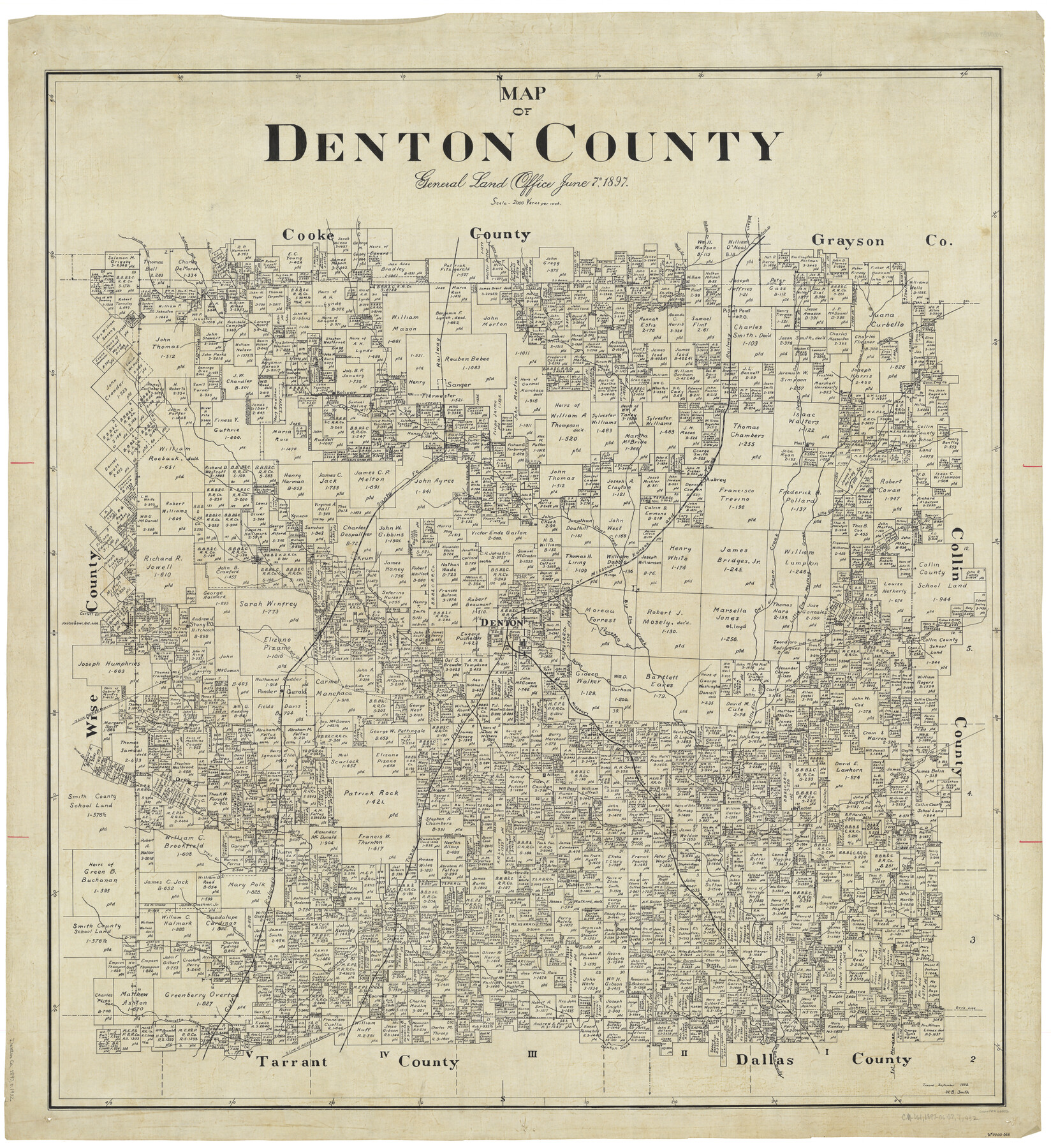
Map of Denton County
-
Map/Doc
66802
-
Collection
General Map Collection
-
Object Dates
6/7/1897 (Creation Date)
-
People and Organizations
Texas General Land Office (Publisher)
-
Counties
Denton
-
Subjects
County
-
Height x Width
45.0 x 41.2 inches
114.3 x 104.7 cm
-
Comments
Traced in September 1932 by W. B. Smith.
Part of: General Map Collection
Collin County Sketch File 15

Print $4.00
- Digital $50.00
Collin County Sketch File 15
1873
Size 10.0 x 8.0 inches
Map/Doc 18880
Dickens County Sketch File D

Print $20.00
- Digital $50.00
Dickens County Sketch File D
1883
Size 15.7 x 14.8 inches
Map/Doc 11330

Shelby County Working Sketch 25

Print $20.00
- Digital $50.00
Shelby County Working Sketch 25
1948
Size 23.5 x 36.2 inches
Map/Doc 63879
Maps of Gulf Intracoastal Waterway, Texas - Sabine River to the Rio Grande and connecting waterways including ship channels

Print $20.00
- Digital $50.00
Maps of Gulf Intracoastal Waterway, Texas - Sabine River to the Rio Grande and connecting waterways including ship channels
1966
Size 14.5 x 22.2 inches
Map/Doc 61941
Uvalde County Working Sketch 67

Print $20.00
- Digital $50.00
Uvalde County Working Sketch 67
2016
Size 24.4 x 36.6 inches
Map/Doc 94082
Packery Channel

Print $20.00
- Digital $50.00
Packery Channel
1950
Size 17.2 x 17.1 inches
Map/Doc 2996
State Prison Lands in Walker County - Wynne Farm, Goree Farm, Dairy Pasture, Cemetery Tract

Print $20.00
- Digital $50.00
State Prison Lands in Walker County - Wynne Farm, Goree Farm, Dairy Pasture, Cemetery Tract
Size 16.9 x 19.1 inches
Map/Doc 62994
Medina County Sketch File 17

Print $40.00
- Digital $50.00
Medina County Sketch File 17
1949
Size 13.1 x 13.3 inches
Map/Doc 31480
Sutton County Boundary File 5a

Print $20.00
- Digital $50.00
Sutton County Boundary File 5a
Size 14.5 x 8.9 inches
Map/Doc 59060
Glasscock County Sketch File 8

Print $6.00
- Digital $50.00
Glasscock County Sketch File 8
Size 9.5 x 14.9 inches
Map/Doc 24168
San Augustine County Sketch File 23

Print $12.00
San Augustine County Sketch File 23
1992
Size 14.5 x 9.0 inches
Map/Doc 35689
You may also like
Duval County Sketch File 34

Print $20.00
- Digital $50.00
Duval County Sketch File 34
Size 28.4 x 36.9 inches
Map/Doc 11391
San Jacinto Co.

Print $20.00
- Digital $50.00
San Jacinto Co.
1889
Size 46.4 x 37.9 inches
Map/Doc 63016
Navigation Maps of Gulf Intracoastal Waterway, Port Arthur to Brownsville, Texas

Print $4.00
- Digital $50.00
Navigation Maps of Gulf Intracoastal Waterway, Port Arthur to Brownsville, Texas
1951
Size 16.7 x 21.2 inches
Map/Doc 65449
Castro County Working Sketch 9

Print $20.00
- Digital $50.00
Castro County Working Sketch 9
1965
Size 43.1 x 47.7 inches
Map/Doc 68646
Coke County Rolled Sketch 5

Print $20.00
- Digital $50.00
Coke County Rolled Sketch 5
1948
Size 25.5 x 23.6 inches
Map/Doc 5505

Cottle County Sketch File 14

Print $50.00
- Digital $50.00
Cottle County Sketch File 14
1918
Size 11.3 x 8.8 inches
Map/Doc 19491
Schleicher County Sketch File 33

Print $8.00
- Digital $50.00
Schleicher County Sketch File 33
1948
Size 11.3 x 8.9 inches
Map/Doc 36534
Brewster County Rolled Sketch 76

Print $20.00
- Digital $50.00
Brewster County Rolled Sketch 76
Size 17.3 x 19.0 inches
Map/Doc 5241
Jasper County Rolled Sketch 2

Print $20.00
- Digital $50.00
Jasper County Rolled Sketch 2
1941
Size 22.5 x 16.6 inches
Map/Doc 6348
Jeff Davis County Rolled Sketch 8

Print $20.00
- Digital $50.00
Jeff Davis County Rolled Sketch 8
Size 40.0 x 41.6 inches
Map/Doc 9264
Cass County Sketch File 5 1/2

Print $4.00
- Digital $50.00
Cass County Sketch File 5 1/2
1851
Size 6.1 x 8.5 inches
Map/Doc 17404