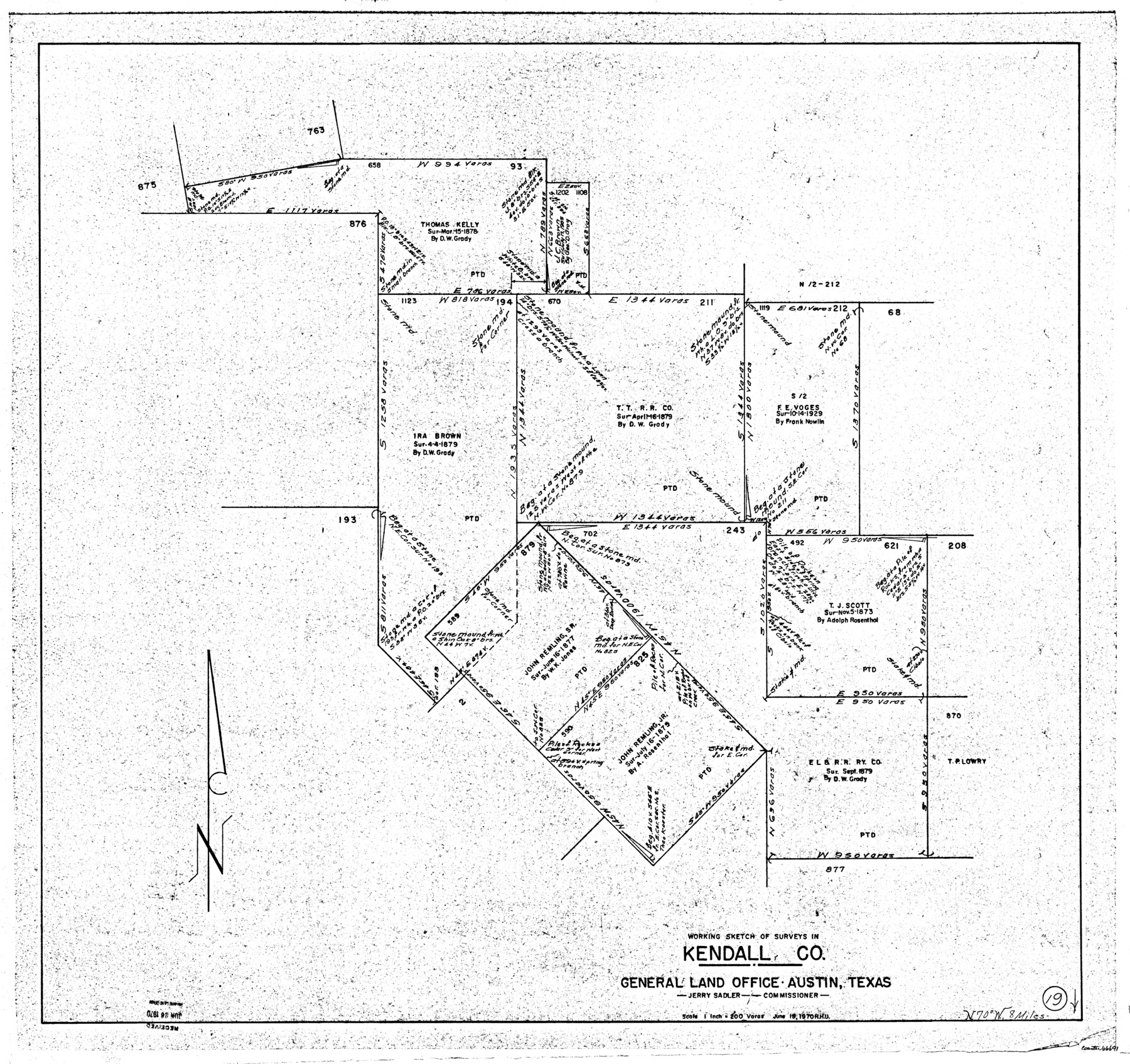
Kendall County Working Sketch 19
-
Map/Doc
66691
-
Collection
General Map Collection
-
Object Dates
6/19/1970 (Creation Date)
-
People and Organizations
Herbert H. Ulbricht (Draftsman)
-
Counties
Kendall
-
Subjects
Surveying Working Sketch
-
Height x Width
31.5 x 33.4 inches
80.0 x 84.8 cm
-
Scale
1" = 200 varas
Part of: General Map Collection
La Salle County Working Sketch 25

Print $20.00
- Digital $50.00
La Salle County Working Sketch 25
1947
Size 32.8 x 41.0 inches
Map/Doc 70326
Fractional Township No. 8 South Range No. 3 West of the indian Meridian, Indian Territory

Print $20.00
- Digital $50.00
Fractional Township No. 8 South Range No. 3 West of the indian Meridian, Indian Territory
1898
Size 19.4 x 24.4 inches
Map/Doc 75194
Reagan County Boundary File 2

Print $20.00
- Digital $50.00
Reagan County Boundary File 2
Size 17.5 x 32.4 inches
Map/Doc 58190
Zavala County Sketch File B

Print $34.00
- Digital $50.00
Zavala County Sketch File B
1908
Size 13.5 x 8.9 inches
Map/Doc 41364
Flight Mission No. BRA-7M, Frame 14, Jefferson County

Print $20.00
- Digital $50.00
Flight Mission No. BRA-7M, Frame 14, Jefferson County
1953
Size 18.6 x 22.3 inches
Map/Doc 85465
Ellis County Sketch File 11

Print $40.00
- Digital $50.00
Ellis County Sketch File 11
1860
Size 12.6 x 16.2 inches
Map/Doc 21847
Aransas County Working Sketch Graphic Index

Print $20.00
- Digital $50.00
Aransas County Working Sketch Graphic Index
1947
Size 36.8 x 36.6 inches
Map/Doc 76455
Harris County Working Sketch 108

Print $20.00
- Digital $50.00
Harris County Working Sketch 108
1981
Size 20.6 x 20.5 inches
Map/Doc 66000
Post Route Map of Texas (Inset 1: Dallas-Fort Worth Area; Inset 2: Texas Panhandle)

Print $40.00
- Digital $50.00
Post Route Map of Texas (Inset 1: Dallas-Fort Worth Area; Inset 2: Texas Panhandle)
1939
Size 56.9 x 39.3 inches
Map/Doc 93668
[Traverse up the Brazos and Colorado River showing distance from county site to county site]
![2054, [Traverse up the Brazos and Colorado River showing distance from county site to county site], General Map Collection](https://historictexasmaps.com/wmedia_w700/maps/2054.tif.jpg)
Print $40.00
- Digital $50.00
[Traverse up the Brazos and Colorado River showing distance from county site to county site]
1871
Size 16.2 x 98.8 inches
Map/Doc 2054
Anderson County Boundary File 9

Print $40.00
- Digital $50.00
Anderson County Boundary File 9
Size 19.7 x 58.3 inches
Map/Doc 49758
Flight Mission No. CUG-3P, Frame 159, Kleberg County

Print $20.00
- Digital $50.00
Flight Mission No. CUG-3P, Frame 159, Kleberg County
1956
Size 18.7 x 22.3 inches
Map/Doc 86279
You may also like
Montague County Working Sketch 20

Print $20.00
- Digital $50.00
Montague County Working Sketch 20
1952
Size 23.0 x 37.0 inches
Map/Doc 71086
San Luis Pass to East Matagorda Bay

Print $20.00
- Digital $50.00
San Luis Pass to East Matagorda Bay
1957
Size 34.9 x 46.9 inches
Map/Doc 69962
Montgomery County Working Sketch 27

Print $20.00
- Digital $50.00
Montgomery County Working Sketch 27
1942
Size 42.1 x 33.4 inches
Map/Doc 71134
Gaines County Working Sketch 14

Print $40.00
- Digital $50.00
Gaines County Working Sketch 14
1957
Size 62.3 x 31.7 inches
Map/Doc 69314
[Blocks A, S4, T2, MO, and vicinity]
![91067, [Blocks A, S4, T2, MO, and vicinity], Twichell Survey Records](https://historictexasmaps.com/wmedia_w700/maps/91067-1.tif.jpg)
Print $3.00
- Digital $50.00
[Blocks A, S4, T2, MO, and vicinity]
Size 15.3 x 10.7 inches
Map/Doc 91067
Wise County Sketch File 24

Print $4.00
- Digital $50.00
Wise County Sketch File 24
1860
Size 12.3 x 7.8 inches
Map/Doc 40570
Travis County Sketch File 22

Print $6.00
- Digital $50.00
Travis County Sketch File 22
1875
Size 8.5 x 8.5 inches
Map/Doc 38327
Frio County Rolled Sketch 17

Print $20.00
- Digital $50.00
Frio County Rolled Sketch 17
1953
Size 32.4 x 44.5 inches
Map/Doc 8907
Culberson County Sketch File 42

Print $14.00
- Digital $50.00
Culberson County Sketch File 42
1966
Size 14.2 x 8.7 inches
Map/Doc 20322
Flight Mission No. CRK-3P, Frame 177, Refugio County

Print $20.00
- Digital $50.00
Flight Mission No. CRK-3P, Frame 177, Refugio County
1956
Size 18.6 x 22.4 inches
Map/Doc 86924
Brazoria County Rolled Sketch 43

Print $20.00
- Digital $50.00
Brazoria County Rolled Sketch 43
Size 24.4 x 19.6 inches
Map/Doc 5177
Cherokee County Sketch File 34

Print $12.00
- Digital $50.00
Cherokee County Sketch File 34
1954
Size 11.2 x 8.9 inches
Map/Doc 18198