Cass County Sketch File 17
[Small office sketch of surveys in the extreme southeast corner of the county]
-
Map/Doc
17418
-
Collection
General Map Collection
-
Counties
Cass
-
Subjects
Surveying Sketch File
-
Height x Width
8.2 x 10.2 inches
20.8 x 25.9 cm
-
Medium
paper, manuscript
Part of: General Map Collection
Travis County Rolled Sketch 17

Print $20.00
- Digital $50.00
Travis County Rolled Sketch 17
1940
Size 18.8 x 25.4 inches
Map/Doc 8019
Hutchinson County Rolled Sketch 44-11

Print $20.00
- Digital $50.00
Hutchinson County Rolled Sketch 44-11
2002
Size 24.0 x 36.0 inches
Map/Doc 77547
Nolan County Working Sketch 6

Print $20.00
- Digital $50.00
Nolan County Working Sketch 6
1950
Size 27.2 x 26.0 inches
Map/Doc 71297
Harrison County State Real Property Sketch 2

Print $20.00
- Digital $50.00
Harrison County State Real Property Sketch 2
1986
Size 23.9 x 25.0 inches
Map/Doc 61667
Pecos County Sketch File 54

Print $20.00
- Digital $50.00
Pecos County Sketch File 54
Size 14.5 x 22.4 inches
Map/Doc 12180
Guadalupe County Working Sketch 11

Print $40.00
- Digital $50.00
Guadalupe County Working Sketch 11
1972
Size 67.7 x 45.0 inches
Map/Doc 63320
South Part Presidio County

Print $20.00
- Digital $50.00
South Part Presidio County
1975
Size 35.0 x 40.3 inches
Map/Doc 95617
Reagan County Rolled Sketch 17

Print $20.00
- Digital $50.00
Reagan County Rolled Sketch 17
Size 33.9 x 32.6 inches
Map/Doc 10623
Val Verde County Rolled Sketch 3

Print $20.00
- Digital $50.00
Val Verde County Rolled Sketch 3
1887
Size 44.8 x 36.5 inches
Map/Doc 10070
McMullen County Rolled Sketch 19

Print $20.00
- Digital $50.00
McMullen County Rolled Sketch 19
1963
Size 26.6 x 39.6 inches
Map/Doc 6735
Lampasas County Boundary File 6

Print $40.00
- Digital $50.00
Lampasas County Boundary File 6
Size 9.1 x 7.8 inches
Map/Doc 56136
Montgomery County Working Sketch 41

Print $20.00
- Digital $50.00
Montgomery County Working Sketch 41
1955
Size 22.9 x 23.6 inches
Map/Doc 71148
You may also like
Grid Map Showing Texas, Louisiana, Arkansas, Mississippi and portions of New Mexico, Oklahoma and Tennessee

Print $40.00
- Digital $50.00
Grid Map Showing Texas, Louisiana, Arkansas, Mississippi and portions of New Mexico, Oklahoma and Tennessee
1940
Size 34.2 x 48.1 inches
Map/Doc 3121
Clarke and Courts' Map of Jefferson County and Beaumont and Sour Lake Oil Fields

Print $20.00
Clarke and Courts' Map of Jefferson County and Beaumont and Sour Lake Oil Fields
1901
Size 28.2 x 24.3 inches
Map/Doc 79289
Webb County Working Sketch 12

Print $20.00
- Digital $50.00
Webb County Working Sketch 12
1921
Size 15.9 x 14.6 inches
Map/Doc 72377
Brazoria County Rolled Sketch 21A

Print $20.00
- Digital $50.00
Brazoria County Rolled Sketch 21A
Size 38.6 x 33.2 inches
Map/Doc 8926
Flight Mission No. DAG-24K, Frame 128, Matagorda County

Print $20.00
- Digital $50.00
Flight Mission No. DAG-24K, Frame 128, Matagorda County
1953
Size 17.2 x 22.5 inches
Map/Doc 86546
Reeves County Rolled Sketch 23

Print $20.00
- Digital $50.00
Reeves County Rolled Sketch 23
1982
Size 19.6 x 25.5 inches
Map/Doc 7491
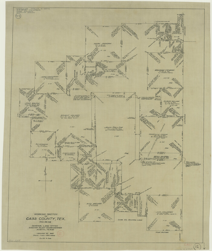
Cass County Working Sketch 12
Print $20.00
- Digital $50.00
Cass County Working Sketch 12
1942
Size 27.0 x 22.9 inches
Map/Doc 67915
[West Half of Hutchinson County South of the Canadian River]
![91179, [West Half of Hutchinson County South of the Canadian River], Twichell Survey Records](https://historictexasmaps.com/wmedia_w700/maps/91179-1.tif.jpg)
Print $20.00
- Digital $50.00
[West Half of Hutchinson County South of the Canadian River]
Size 18.4 x 17.0 inches
Map/Doc 91179
Railroad Track Map, H&TCRRCo., Falls County, Texas

Print $4.00
- Digital $50.00
Railroad Track Map, H&TCRRCo., Falls County, Texas
1918
Size 11.8 x 18.6 inches
Map/Doc 62836
Hardin County Sketch File 31

Print $2.00
- Digital $50.00
Hardin County Sketch File 31
Size 8.5 x 7.1 inches
Map/Doc 25162

Denton County Sketch File 10

Print $2.00
- Digital $50.00
Denton County Sketch File 10
1856
Size 8.5 x 13.5 inches
Map/Doc 20708