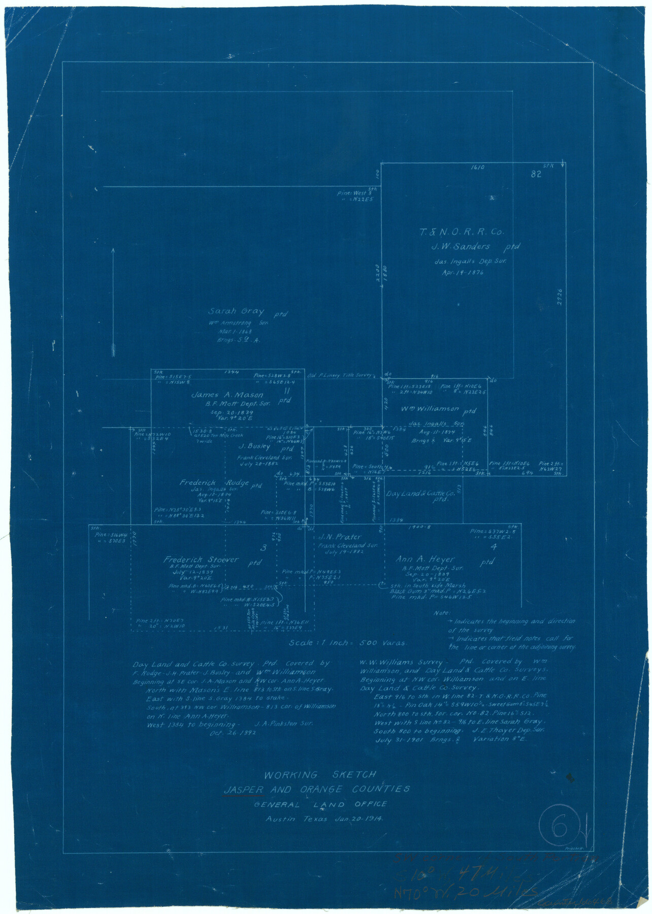
Jasper County Working Sketch 6
-
Map/Doc
66468
-
Collection
General Map Collection
-
Object Dates
1/20/1914 (Creation Date)
-
People and Organizations
J.W. Pritchett (Draftsman)
-
Counties
Jasper Orange
-
Subjects
Surveying Working Sketch
-
Height x Width
15.9 x 11.3 inches
40.4 x 28.7 cm
-
Scale
1" = 500 varas
Part of: General Map Collection
Sherman County Boundary File 1

Print $20.00
- Digital $50.00
Sherman County Boundary File 1
Size 11.4 x 8.9 inches
Map/Doc 58751
Terrell County Rolled Sketch 30

Print $40.00
- Digital $50.00
Terrell County Rolled Sketch 30
1931
Size 38.9 x 49.0 inches
Map/Doc 10735
Cass County Rolled Sketch OF

Print $20.00
- Digital $50.00
Cass County Rolled Sketch OF
1937
Size 16.2 x 24.3 inches
Map/Doc 5414
Matagorda County Rolled Sketch 34

Print $20.00
- Digital $50.00
Matagorda County Rolled Sketch 34
Size 25.4 x 40.5 inches
Map/Doc 6695
Borden County Rolled Sketch 6

Print $20.00
- Digital $50.00
Borden County Rolled Sketch 6
Size 24.6 x 18.6 inches
Map/Doc 5156
[Cotton Belt, St. Louis Southwestern Railway of Texas, Alignment through Smith County]
![64375, [Cotton Belt, St. Louis Southwestern Railway of Texas, Alignment through Smith County], General Map Collection](https://historictexasmaps.com/wmedia_w700/maps/64375.tif.jpg)
Print $20.00
- Digital $50.00
[Cotton Belt, St. Louis Southwestern Railway of Texas, Alignment through Smith County]
1903
Size 21.3 x 28.5 inches
Map/Doc 64375
Map of the European Settlements in Mexico or New Spain and the West Indies

Print $20.00
- Digital $50.00
Map of the European Settlements in Mexico or New Spain and the West Indies
1783
Size 14.1 x 21.1 inches
Map/Doc 93643
Titus County Sketch File 4

Print $4.00
- Digital $50.00
Titus County Sketch File 4
Size 8.2 x 10.2 inches
Map/Doc 38136
San Patricio County Sketch File 28

Print $53.00
San Patricio County Sketch File 28
1935
Size 9.4 x 7.0 inches
Map/Doc 36087
[Surveys in Polk and Chambers Counties]
![355, [Surveys in Polk and Chambers Counties], General Map Collection](https://historictexasmaps.com/wmedia_w700/maps/355.tif.jpg)
Print $3.00
- Digital $50.00
[Surveys in Polk and Chambers Counties]
Size 11.7 x 14.4 inches
Map/Doc 355
[Sketch for Mineral Application 19144 - Pecos River Bed]
![65573, [Sketch for Mineral Application 19144 - Pecos River Bed], General Map Collection](https://historictexasmaps.com/wmedia_w700/maps/65573.tif.jpg)
Print $20.00
- Digital $50.00
[Sketch for Mineral Application 19144 - Pecos River Bed]
1927
Size 45.2 x 46.4 inches
Map/Doc 65573
Brazoria County Rolled Sketch 40

Print $20.00
- Digital $50.00
Brazoria County Rolled Sketch 40
1954
Size 32.1 x 21.5 inches
Map/Doc 5175
You may also like
Terry County Boundary File 4a

Print $70.00
- Digital $50.00
Terry County Boundary File 4a
Size 11.4 x 8.8 inches
Map/Doc 59249
Garza County Sketch File H

Print $20.00
- Digital $50.00
Garza County Sketch File H
Size 43.1 x 38.7 inches
Map/Doc 10472
Crockett County Sketch File 97

Print $20.00
- Digital $50.00
Crockett County Sketch File 97
Size 14.1 x 9.3 inches
Map/Doc 19966
Flight Mission No. CLL-1N, Frame 79, Willacy County

Print $20.00
- Digital $50.00
Flight Mission No. CLL-1N, Frame 79, Willacy County
1954
Size 18.6 x 22.2 inches
Map/Doc 87025
Hudspeth County Sketch File 36

Print $12.00
- Digital $50.00
Hudspeth County Sketch File 36
1901
Size 10.5 x 8.2 inches
Map/Doc 27003
Brazoria County Sketch File 1

Print $4.00
- Digital $50.00
Brazoria County Sketch File 1
1861
Size 9.7 x 8.3 inches
Map/Doc 14916
Freestone County Working Sketch 11

Print $40.00
- Digital $50.00
Freestone County Working Sketch 11
1978
Size 31.4 x 51.4 inches
Map/Doc 69253
Jefferson County Sketch File 18

Print $40.00
- Digital $50.00
Jefferson County Sketch File 18
Size 15.7 x 14.0 inches
Map/Doc 28167
Runnels County Sketch File H

Print $4.00
Runnels County Sketch File H
1890
Size 14.3 x 8.8 inches
Map/Doc 35450
Williamson County Working Sketch 13

Print $20.00
- Digital $50.00
Williamson County Working Sketch 13
1980
Size 26.6 x 43.5 inches
Map/Doc 72573

Map of Re-Survey of Blk. 34 & 35 T5N

Print $40.00
- Digital $50.00
Map of Re-Survey of Blk. 34 & 35 T5N
1915
Size 53.5 x 39.2 inches
Map/Doc 89765