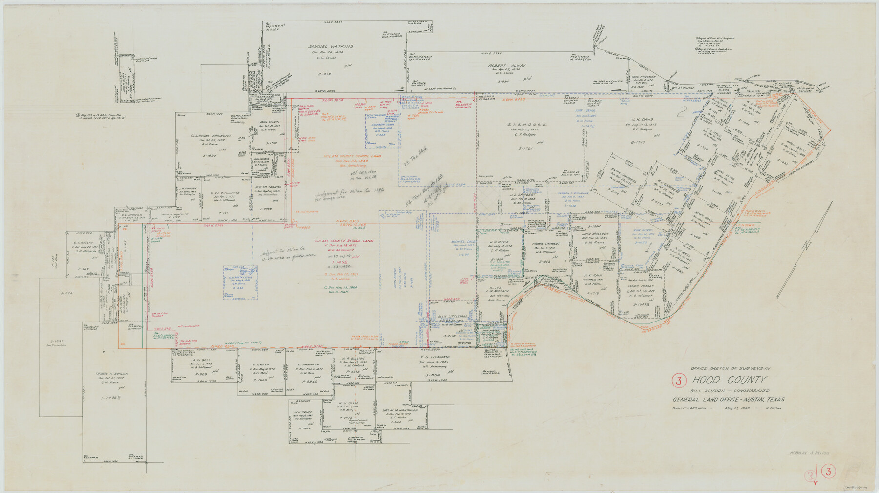
Hood County Working Sketch 3
-
Map/Doc
66197
-
Collection
General Map Collection
-
Object Dates
5/13/1960 (Creation Date)
-
People and Organizations
Herman Forbes (Draftsman)
-
Counties
Hood
-
Subjects
Surveying Working Sketch
-
Height x Width
24.6 x 43.9 inches
62.5 x 111.5 cm
-
Scale
1" = 400 varas
Part of: General Map Collection
Eastham State Farm - Houston, Walker Counties and Ferguson State Farm, Madison County

Print $20.00
- Digital $50.00
Eastham State Farm - Houston, Walker Counties and Ferguson State Farm, Madison County
Size 27.7 x 40.3 inches
Map/Doc 62975
Houston County Working Sketch 3

Print $20.00
- Digital $50.00
Houston County Working Sketch 3
Size 16.7 x 18.5 inches
Map/Doc 66233
Webb County Working Sketch 19

Print $20.00
- Digital $50.00
Webb County Working Sketch 19
1925
Size 32.6 x 29.8 inches
Map/Doc 72384
Flight Mission No. DQN-5K, Frame 45, Calhoun County

Print $20.00
- Digital $50.00
Flight Mission No. DQN-5K, Frame 45, Calhoun County
1953
Size 18.4 x 22.1 inches
Map/Doc 84390
Flight Mission No. DAG-24K, Frame 137, Matagorda County

Print $20.00
- Digital $50.00
Flight Mission No. DAG-24K, Frame 137, Matagorda County
1953
Size 18.5 x 22.2 inches
Map/Doc 86555
Garza County Sketch File 31

Print $10.00
- Digital $50.00
Garza County Sketch File 31
1914
Size 13.4 x 8.9 inches
Map/Doc 24104
Karnes County Working Sketch 10

Print $20.00
- Digital $50.00
Karnes County Working Sketch 10
1970
Size 35.5 x 26.3 inches
Map/Doc 66658
Galveston County Rolled Sketch 41

Print $20.00
- Digital $50.00
Galveston County Rolled Sketch 41
1988
Size 23.1 x 37.0 inches
Map/Doc 5972
Jeff Davis County Working Sketch 49

Print $20.00
- Digital $50.00
Jeff Davis County Working Sketch 49
2008
Size 38.0 x 35.7 inches
Map/Doc 88816
Anderson County Sketch File 16

Print $6.00
- Digital $50.00
Anderson County Sketch File 16
1849
Size 8.6 x 6.5 inches
Map/Doc 12783
Index sheet to accompany map of survey for connecting the inland waters along margin of the Gulf of Mexico from Donaldsonville in Louisiana to the Rio Grande River in Texas

Print $20.00
- Digital $50.00
Index sheet to accompany map of survey for connecting the inland waters along margin of the Gulf of Mexico from Donaldsonville in Louisiana to the Rio Grande River in Texas
1874
Size 18.1 x 26.9 inches
Map/Doc 72694
Flight Mission No. DAG-24K, Frame 36, Matagorda County

Print $20.00
- Digital $50.00
Flight Mission No. DAG-24K, Frame 36, Matagorda County
1953
Size 18.5 x 22.2 inches
Map/Doc 86523
You may also like
Hood County Rolled Sketch 1
Print $20.00
- Digital $50.00
Hood County Rolled Sketch 1
1946
Size 31.9 x 38.6 inches
Map/Doc 9177
Map of survey 189, T. C. R.R. Co. in Travis County, Texas

Print $20.00
- Digital $50.00
Map of survey 189, T. C. R.R. Co. in Travis County, Texas
1915
Size 18.6 x 15.2 inches
Map/Doc 78479
Jefferson County Rolled Sketch 43

Print $40.00
- Digital $50.00
Jefferson County Rolled Sketch 43
1957
Size 50.1 x 18.2 inches
Map/Doc 9303
Working Sketch Armstrong County

Print $20.00
- Digital $50.00
Working Sketch Armstrong County
1909
Size 32.0 x 23.8 inches
Map/Doc 90264
The Republic County of Harrison. January 8, 1844

Print $20.00
The Republic County of Harrison. January 8, 1844
2020
Size 18.6 x 21.7 inches
Map/Doc 96175
[Surveys in the Bexar District along the Guadalupe River and Cibolo Creek]
![3169, [Surveys in the Bexar District along the Guadalupe River and Cibolo Creek], General Map Collection](https://historictexasmaps.com/wmedia_w700/maps/3169.tif.jpg)
Print $20.00
- Digital $50.00
[Surveys in the Bexar District along the Guadalupe River and Cibolo Creek]
1846
Size 9.6 x 18.3 inches
Map/Doc 3169
Jasper County Sketch File 26

Print $16.00
- Digital $50.00
Jasper County Sketch File 26
1944
Size 11.2 x 8.8 inches
Map/Doc 27834
Plat of 39 7/10 Acres of Land Owned by W. D. Twichell

Print $2.00
- Digital $50.00
Plat of 39 7/10 Acres of Land Owned by W. D. Twichell
Size 7.1 x 8.1 inches
Map/Doc 92089
Preliminary Chart of San Luis Pass, Texas

Print $20.00
Preliminary Chart of San Luis Pass, Texas
1853
Size 16.4 x 21.2 inches
Map/Doc 76251
Garza County Sketch File 11

Print $4.00
- Digital $50.00
Garza County Sketch File 11
1901
Size 11.3 x 8.8 inches
Map/Doc 24066
Flight Mission No. BRA-7M, Frame 38, Jefferson County

Print $20.00
- Digital $50.00
Flight Mission No. BRA-7M, Frame 38, Jefferson County
1953
Size 18.6 x 22.4 inches
Map/Doc 85489
Harris County Working Sketch 87

Print $20.00
- Digital $50.00
Harris County Working Sketch 87
1972
Size 34.1 x 31.0 inches
Map/Doc 65979