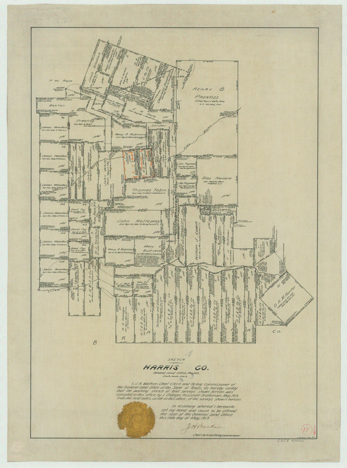
Harris County Working Sketch 11
-
Map/Doc
65903
-
Collection
General Map Collection
-
Object Dates
5/16/1913 (Creation Date)
-
People and Organizations
L. Ehlinger (Draftsman)
-
Counties
Harris
-
Subjects
Surveying Working Sketch
-
Height x Width
30.4 x 22.5 inches
77.2 x 57.2 cm
-
Scale
1" = 1000 varas
Part of: General Map Collection
Culberson County Rolled Sketch 59

Print $14.00
- Digital $50.00
Culberson County Rolled Sketch 59
Size 37.3 x 78.1 inches
Map/Doc 8760
Midland County Boundary File 3

Print $4.00
- Digital $50.00
Midland County Boundary File 3
Size 8.2 x 8.3 inches
Map/Doc 57174
Sterling County Sketch File 25

Print $4.00
- Digital $50.00
Sterling County Sketch File 25
1892
Size 11.1 x 8.9 inches
Map/Doc 37192
Dimmit County

Print $40.00
- Digital $50.00
Dimmit County
1976
Size 42.2 x 48.9 inches
Map/Doc 77265
Fisher County Sketch File 9

Print $4.00
- Digital $50.00
Fisher County Sketch File 9
1893
Size 11.1 x 8.5 inches
Map/Doc 22575
Kimble County Working Sketch 39

Print $20.00
- Digital $50.00
Kimble County Working Sketch 39
1947
Size 30.8 x 23.5 inches
Map/Doc 70107
King County Working Sketch Graphic Index

Print $20.00
- Digital $50.00
King County Working Sketch Graphic Index
1947
Size 44.2 x 39.5 inches
Map/Doc 76608
Sabine Pass and mouth of the River Sabine

Print $20.00
- Digital $50.00
Sabine Pass and mouth of the River Sabine
1840
Size 27.0 x 18.3 inches
Map/Doc 72726
Smith County Rolled Sketch 6A3

Print $40.00
- Digital $50.00
Smith County Rolled Sketch 6A3
1990
Size 48.6 x 36.8 inches
Map/Doc 10698
Cooke County Sketch File 11

Print $4.00
- Digital $50.00
Cooke County Sketch File 11
1858
Size 12.4 x 8.2 inches
Map/Doc 19244
Kleberg County Rolled Sketch 10-18

Print $20.00
- Digital $50.00
Kleberg County Rolled Sketch 10-18
1952
Size 37.3 x 38.2 inches
Map/Doc 9364
Polk County Working Sketch 25

Print $20.00
- Digital $50.00
Polk County Working Sketch 25
1958
Size 34.6 x 29.0 inches
Map/Doc 71641
You may also like
Crosby County Boundary File 5a

Print $60.00
- Digital $50.00
Crosby County Boundary File 5a
Size 8.0 x 35.4 inches
Map/Doc 52044
Texas - Official Highway Travel Map

Texas - Official Highway Travel Map
Size 27.4 x 36.4 inches
Map/Doc 94299
[Sketch showing B. S. & F. survey 9, sections 162, 163, 178, 179 in town of Bush]
![91728, [Sketch showing B. S. & F. survey 9, sections 162, 163, 178, 179 in town of Bush], Twichell Survey Records](https://historictexasmaps.com/wmedia_w700/maps/91728-1.tif.jpg)
Print $20.00
- Digital $50.00
[Sketch showing B. S. & F. survey 9, sections 162, 163, 178, 179 in town of Bush]
Size 12.0 x 16.1 inches
Map/Doc 91728
General Highway Map, Kimble County, Texas

Print $20.00
General Highway Map, Kimble County, Texas
1961
Size 24.6 x 18.2 inches
Map/Doc 79554
Baylor County Boundary File 4

Print $6.00
- Digital $50.00
Baylor County Boundary File 4
Size 11.2 x 8.6 inches
Map/Doc 50389
Frio County Working Sketch 25

Print $40.00
- Digital $50.00
Frio County Working Sketch 25
1989
Size 35.4 x 50.0 inches
Map/Doc 69299
Amistad International Reservoir on Rio Grande 93

Print $20.00
- Digital $50.00
Amistad International Reservoir on Rio Grande 93
1950
Size 28.5 x 40.7 inches
Map/Doc 75523
Fort Bend County Working Sketch 32

Print $20.00
- Digital $50.00
Fort Bend County Working Sketch 32
2000
Size 36.5 x 42.5 inches
Map/Doc 69238
Map of Colorado County

Print $20.00
- Digital $50.00
Map of Colorado County
1881
Size 22.5 x 21.4 inches
Map/Doc 3427
Leon County Rolled Sketch 27

Print $40.00
- Digital $50.00
Leon County Rolled Sketch 27
1990
Size 54.3 x 45.0 inches
Map/Doc 9436
Calhoun County Rolled Sketch 11
Print $3.00
- Digital $50.00
Calhoun County Rolled Sketch 11
1942
Size 10.9 x 16.2 inches
Map/Doc 5462
Presidio County Working Sketch 97

Print $20.00
- Digital $50.00
Presidio County Working Sketch 97
1978
Size 28.2 x 28.0 inches
Map/Doc 71774