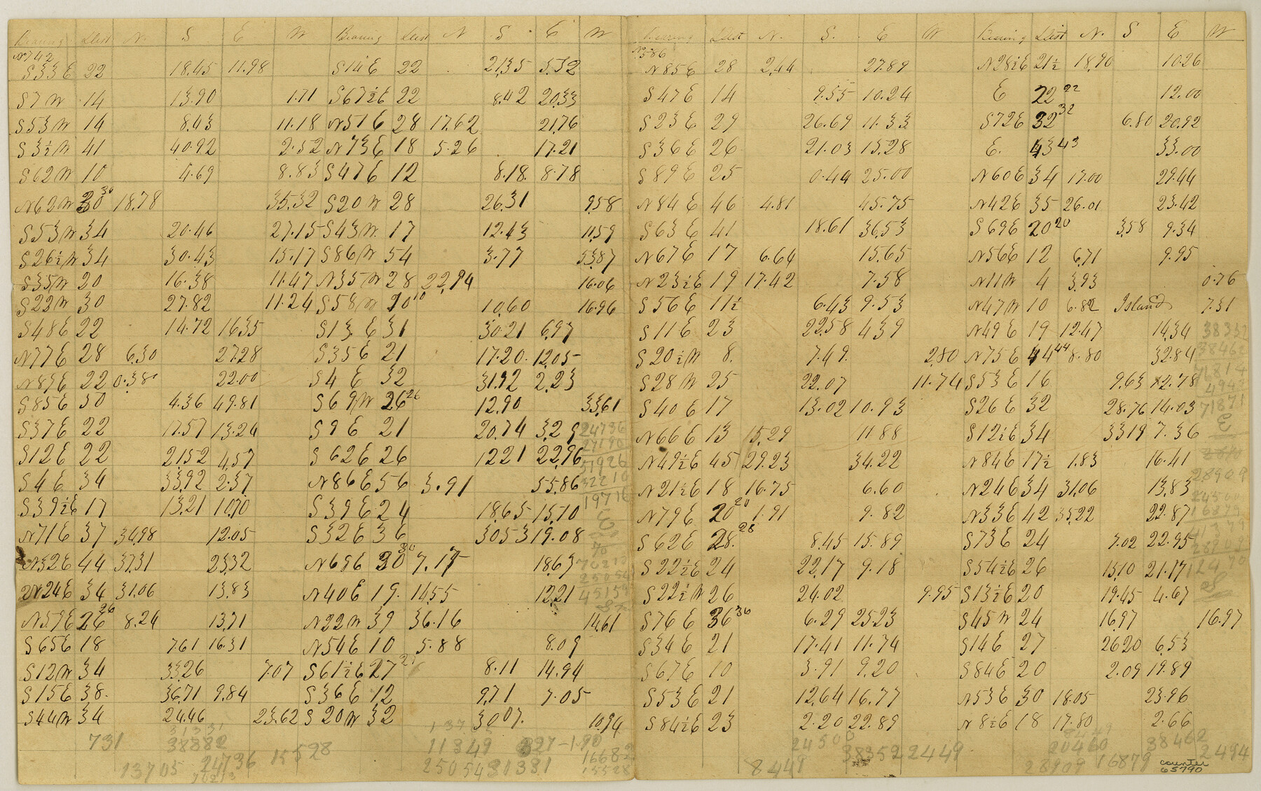
Meanders of Sulphur Fork of Red River, Red River County, Texas
K-3-7
-
Map/Doc
65790
-
Collection
General Map Collection
-
Object Dates
1841 (Creation Date)
-
Counties
Red River
-
Subjects
River Surveys
-
Height x Width
10.0 x 16.0 inches
25.4 x 40.6 cm
Part of: General Map Collection
Aransas Pass to Baffin Bay

Print $20.00
- Digital $50.00
Aransas Pass to Baffin Bay
1971
Size 42.3 x 35.2 inches
Map/Doc 73417
Pecos County Boundary File 2

Print $38.00
- Digital $50.00
Pecos County Boundary File 2
Size 11.2 x 8.7 inches
Map/Doc 57871
Map of Chicago, Rock Island & Texas Railway through Wise and Tarrant County, Texas

Print $20.00
- Digital $50.00
Map of Chicago, Rock Island & Texas Railway through Wise and Tarrant County, Texas
1893
Size 19.6 x 43.7 inches
Map/Doc 64429
[Beaumont, Sour Lake and Western Ry. Right of Way and Alignment - Frisco]
![64128, [Beaumont, Sour Lake and Western Ry. Right of Way and Alignment - Frisco], General Map Collection](https://historictexasmaps.com/wmedia_w700/maps/64128.tif.jpg)
Print $20.00
- Digital $50.00
[Beaumont, Sour Lake and Western Ry. Right of Way and Alignment - Frisco]
1910
Size 20.1 x 45.9 inches
Map/Doc 64128
Bandera County Sketch File 22

Print $4.00
- Digital $50.00
Bandera County Sketch File 22
Size 12.6 x 7.9 inches
Map/Doc 14012
Map of Burleson County

Print $20.00
- Digital $50.00
Map of Burleson County
1856
Size 22.0 x 31.5 inches
Map/Doc 3345
La Salle County Working Sketch 35

Print $6.00
- Digital $50.00
La Salle County Working Sketch 35
1958
Size 31.4 x 16.8 inches
Map/Doc 70336
Lynn County Rolled Sketch WR

Print $20.00
- Digital $50.00
Lynn County Rolled Sketch WR
Size 14.7 x 23.8 inches
Map/Doc 6656
Flight Mission No. CGI-1N, Frame 166, Cameron County

Print $20.00
- Digital $50.00
Flight Mission No. CGI-1N, Frame 166, Cameron County
1955
Size 18.5 x 22.2 inches
Map/Doc 84501
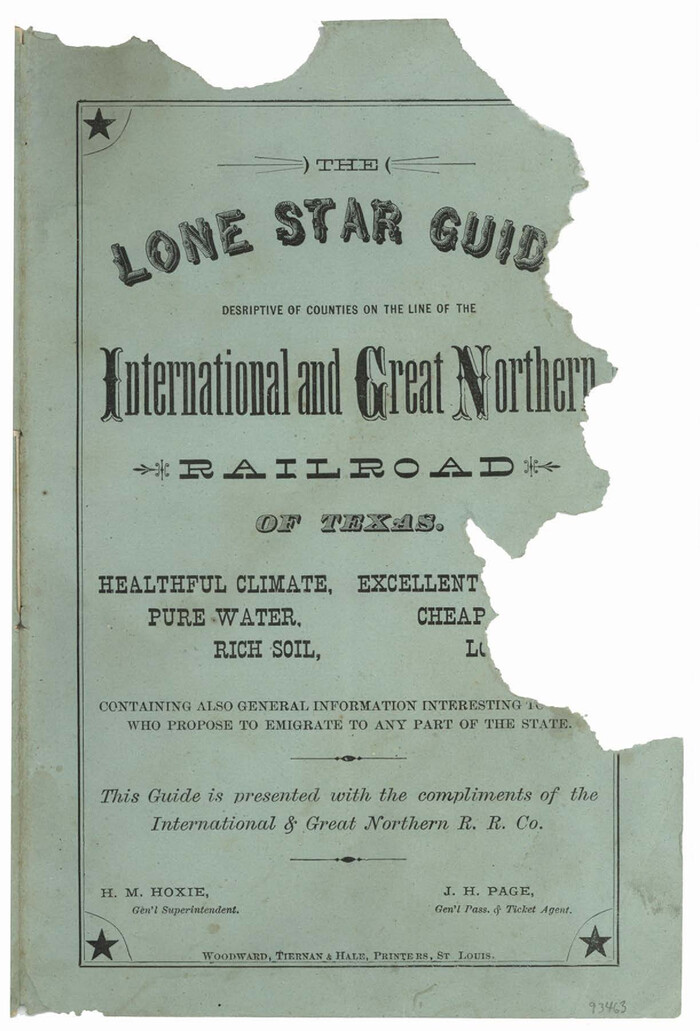
International and Great Northern Railroad Lone Star Route and Connections
Print $20.00
- Digital $50.00
International and Great Northern Railroad Lone Star Route and Connections
1877
Map/Doc 93463
Brewster County Rolled Sketch 81

Print $20.00
- Digital $50.00
Brewster County Rolled Sketch 81
Size 38.9 x 32.6 inches
Map/Doc 41812
McMullen County Working Sketch 33

Print $20.00
- Digital $50.00
McMullen County Working Sketch 33
1959
Size 37.3 x 27.0 inches
Map/Doc 70734
You may also like
Map of Chicago, Rock Island & Texas Railway through Montague and Wise Counties, Texas

Print $40.00
- Digital $50.00
Map of Chicago, Rock Island & Texas Railway through Montague and Wise Counties, Texas
1893
Size 20.2 x 124.5 inches
Map/Doc 64468
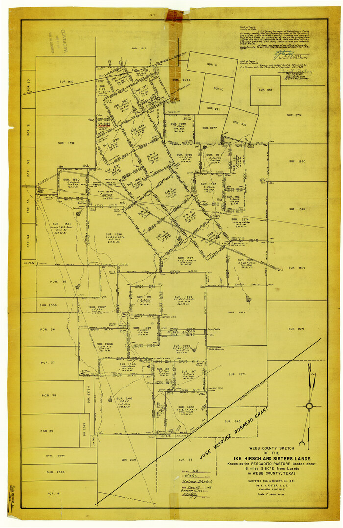
Webb County Rolled Sketch 64
Print $20.00
- Digital $50.00
Webb County Rolled Sketch 64
1948
Size 42.0 x 27.3 inches
Map/Doc 8213
Montgomery County Working Sketch 2

Print $20.00
- Digital $50.00
Montgomery County Working Sketch 2
1914
Size 14.5 x 23.2 inches
Map/Doc 71108
Crockett County Sketch File 27

Print $10.00
- Digital $50.00
Crockett County Sketch File 27
1883
Size 9.1 x 14.5 inches
Map/Doc 19717
Pecos County Sketch File 49b

Print $6.00
- Digital $50.00
Pecos County Sketch File 49b
1920
Size 16.9 x 11.8 inches
Map/Doc 33766
Harris County Rolled Sketch 88

Print $20.00
- Digital $50.00
Harris County Rolled Sketch 88
1935
Size 34.4 x 23.0 inches
Map/Doc 6121
El Paso County Sketch File 25

Print $20.00
- Digital $50.00
El Paso County Sketch File 25
Size 18.5 x 22.3 inches
Map/Doc 11456
Edwards County Rolled Sketch 9

Print $20.00
- Digital $50.00
Edwards County Rolled Sketch 9
1885
Size 29.3 x 42.8 inches
Map/Doc 5802
Map of Africa engraved to illustrate Mitchell's school and family geography (Inset 1: Map of Egypt / Inset 2: Map of Liberia)

Print $20.00
- Digital $50.00
Map of Africa engraved to illustrate Mitchell's school and family geography (Inset 1: Map of Egypt / Inset 2: Map of Liberia)
1839
Size 9.5 x 11.8 inches
Map/Doc 93507
Colorado County Sketch File 14

Print $8.00
- Digital $50.00
Colorado County Sketch File 14
1874
Size 12.8 x 8.0 inches
Map/Doc 18939
Clay County Sketch File 48

Print $26.00
- Digital $50.00
Clay County Sketch File 48
1919
Size 14.2 x 8.6 inches
Map/Doc 18487
Kimble County Rolled Sketch 34

Print $20.00
- Digital $50.00
Kimble County Rolled Sketch 34
1976
Size 35.0 x 20.2 inches
Map/Doc 6524