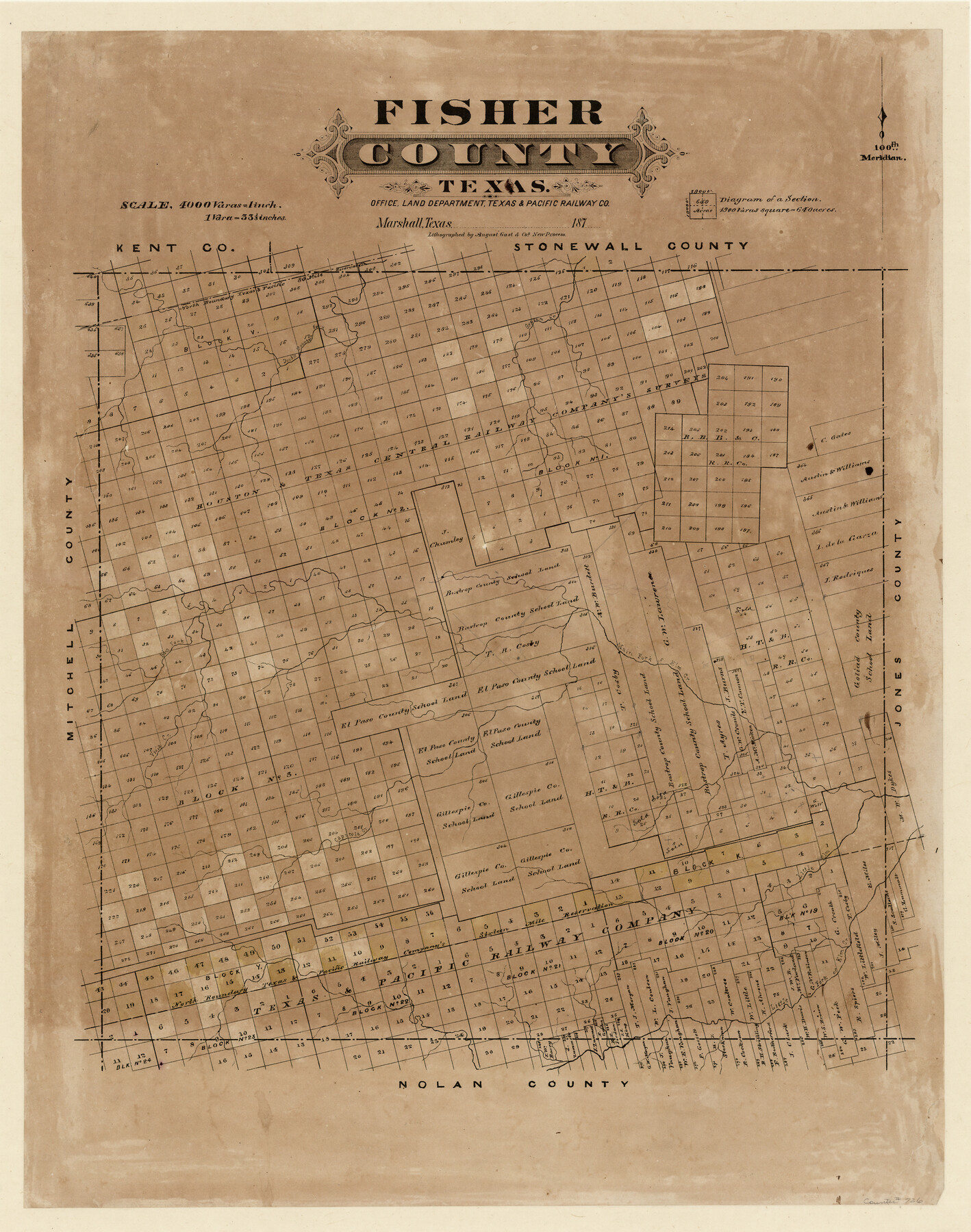
Fisher County, Texas
-
Map/Doc
726
-
Collection
Maddox Collection
-
Object Dates
1870 (Creation Date)
-
People and Organizations
Texas and Pacific Railroad Company, Marshall, TX (Publisher)
August Gast & Co. (Lithographer)
-
Counties
Fisher
-
Subjects
County
-
Height x Width
22.5 x 17.6 inches
57.2 x 44.7 cm
-
Medium
paper, etching/engraving/lithograph
-
Scale
1:4000
-
Comments
Conservation funded by Friends of the Texas General Land Office in 2011.
-
Features
Gypsum Creek
Double Mountain Fork
Main Fork of Elm Creek
Elm Fork [of Elm Creek]
Viola Creek
Capitola Creek
Little Elm [Creek]
Little Fork of Elm Creek
Part of: Maddox Collection
Sketch of Motley Co.

Print $20.00
- Digital $50.00
Sketch of Motley Co.
1883
Size 19.7 x 20.2 inches
Map/Doc 75560
Map of Survey 7, Block 1, D.B. Gardner

Print $20.00
- Digital $50.00
Map of Survey 7, Block 1, D.B. Gardner
1915
Size 16.9 x 22.3 inches
Map/Doc 5067
Map of Duval County, Texas

Print $20.00
- Digital $50.00
Map of Duval County, Texas
1880
Size 29.8 x 22.6 inches
Map/Doc 712
Brazoria County, Texas

Print $20.00
- Digital $50.00
Brazoria County, Texas
1877
Size 24.7 x 21.7 inches
Map/Doc 425
Map of Rains County, Texas

Print $3.00
- Digital $50.00
Map of Rains County, Texas
1880
Size 11.7 x 12.0 inches
Map/Doc 541
Map of the Western Part of Travis County, Texas

Print $20.00
- Digital $50.00
Map of the Western Part of Travis County, Texas
1919
Size 36.2 x 29.9 inches
Map/Doc 10754
Sketch showing subdivision of surveys in Webb Co., Texas

Print $20.00
- Digital $50.00
Sketch showing subdivision of surveys in Webb Co., Texas
1933
Size 18.2 x 20.1 inches
Map/Doc 459
Ellis County, Texas

Print $20.00
- Digital $50.00
Ellis County, Texas
1879
Size 21.2 x 29.6 inches
Map/Doc 714
Survey of Lots 1, 2, 3, 4 and 5, Block 12G Fair View Park, Austin Texas

Print $20.00
- Digital $50.00
Survey of Lots 1, 2, 3, 4 and 5, Block 12G Fair View Park, Austin Texas
1914
Size 23.1 x 11.0 inches
Map/Doc 83431
[Pecos County Sketch]
![444, [Pecos County Sketch], Maddox Collection](https://historictexasmaps.com/wmedia_w700/maps/444.tif.jpg)
Print $20.00
- Digital $50.00
[Pecos County Sketch]
1880
Size 38.5 x 31.3 inches
Map/Doc 444
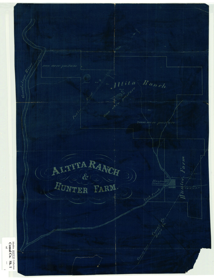
Altita Ranch & Hunter Farm
Print $20.00
- Digital $50.00
Altita Ranch & Hunter Farm
Size 20.2 x 15.6 inches
Map/Doc 492
Map of the C.C. Browning survey 412 enlarged from General Land Office map of the west part of Travis County, Texas

Print $3.00
- Digital $50.00
Map of the C.C. Browning survey 412 enlarged from General Land Office map of the west part of Travis County, Texas
1920
Size 11.3 x 9.1 inches
Map/Doc 10752
You may also like
Flight Mission No. DQN-2K, Frame 34, Calhoun County

Print $20.00
- Digital $50.00
Flight Mission No. DQN-2K, Frame 34, Calhoun County
1953
Size 18.5 x 22.2 inches
Map/Doc 84241
Minutes of the Ayuntamiento of San Felipe de Austin Vol. 3

Minutes of the Ayuntamiento of San Felipe de Austin Vol. 3
Size 13.1 x 10.3 inches
Map/Doc 94262
Live Oak County Rolled Sketch 7

Print $20.00
- Digital $50.00
Live Oak County Rolled Sketch 7
1951
Size 31.3 x 36.9 inches
Map/Doc 6635
Navarro County Working Sketch 12

Print $40.00
- Digital $50.00
Navarro County Working Sketch 12
1979
Size 37.2 x 48.8 inches
Map/Doc 71242
Correct Map of Texas

Print $20.00
- Digital $50.00
Correct Map of Texas
1873
Size 21.5 x 16.9 inches
Map/Doc 95775
El Paso County Rolled Sketch 42

Print $20.00
- Digital $50.00
El Paso County Rolled Sketch 42
Size 34.5 x 24.5 inches
Map/Doc 5828
[F. W. & D. C. Ry. Co. Alignment and Right of Way Map, Clay County]
![64736, [F. W. & D. C. Ry. Co. Alignment and Right of Way Map, Clay County], General Map Collection](https://historictexasmaps.com/wmedia_w700/maps/64736-GC.tif.jpg)
Print $20.00
- Digital $50.00
[F. W. & D. C. Ry. Co. Alignment and Right of Way Map, Clay County]
1927
Size 18.6 x 11.7 inches
Map/Doc 64736
Rand, McNally Official 1922 Auto Trails Map, District Number 18

Print $20.00
- Digital $50.00
Rand, McNally Official 1922 Auto Trails Map, District Number 18
1922
Size 27.1 x 34.7 inches
Map/Doc 95887
Right of Way and Track Map of The Missouri, Kansas & Texas Railway of Texas

Print $40.00
- Digital $50.00
Right of Way and Track Map of The Missouri, Kansas & Texas Railway of Texas
1918
Size 25.6 x 52.6 inches
Map/Doc 64525
Chocolate Bay, West Portion of West Bay and Vicinity, and Galveston Cos. Showing Subdivision for Mineral Development.

Print $40.00
- Digital $50.00
Chocolate Bay, West Portion of West Bay and Vicinity, and Galveston Cos. Showing Subdivision for Mineral Development.
1948
Size 43.0 x 55.9 inches
Map/Doc 3012
Upton County Rolled Sketch 60

Print $20.00
- Digital $50.00
Upton County Rolled Sketch 60
2021
Size 35.9 x 24.0 inches
Map/Doc 96569
Harrison County Sketch File 18

Print $20.00
- Digital $50.00
Harrison County Sketch File 18
1954
Size 23.2 x 26.9 inches
Map/Doc 11691