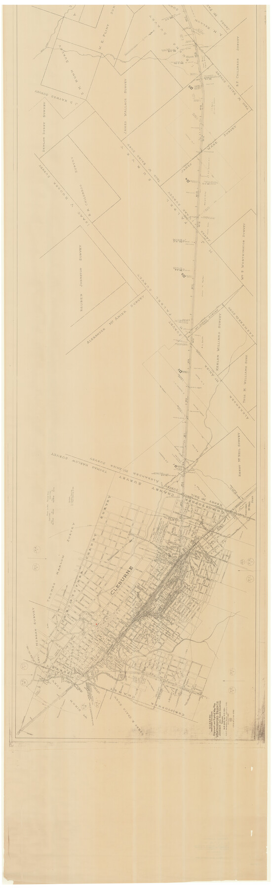
G. C. & S. F. Ry. Northern-Division, Alignment and Right of Way Map, Weatherford Branch, Johnson and Hood Counties, Texas
M.P. 0+0 to M.P. 22+
Z-2-168
-
Map/Doc
64647
-
Collection
General Map Collection
-
Object Dates
1935 (Creation Date)
1943/6/25 (File Date)
-
Counties
Tarrant Johnson Hood
-
Subjects
Railroads
-
Height x Width
37.2 x 121.7 inches
94.5 x 309.1 cm
-
Medium
blueprint/diazo
-
Scale
1" = 400 feet
-
Comments
See counter nos. 64648 through 64654 for other segments.
-
Features
GC&SF
East Fork of Buffalo Creek
[Railroad line] to Hillsboro
West Fork of Buffalo Creek
Alvarado Road
State Highway 122
Nolan Creek
martins Branch [of Nolan Creek]
Part of: General Map Collection
Flight Mission No. CLL-1N, Frame 9, Willacy County

Print $20.00
- Digital $50.00
Flight Mission No. CLL-1N, Frame 9, Willacy County
1954
Size 18.4 x 22.1 inches
Map/Doc 86996
Flight Mission No. BRE-2P, Frame 94, Nueces County

Print $20.00
- Digital $50.00
Flight Mission No. BRE-2P, Frame 94, Nueces County
1956
Size 18.6 x 22.3 inches
Map/Doc 86779

Lubbock County Boundary File 3

Print $2.00
- Digital $50.00
Lubbock County Boundary File 3
Size 11.3 x 8.8 inches
Map/Doc 56490
[Right of Way Map, Belton Branch of the M.K.&T. RR.]
![64222, [Right of Way Map, Belton Branch of the M.K.&T. RR.], General Map Collection](https://historictexasmaps.com/wmedia_w700/maps/64222.tif.jpg)
Print $20.00
- Digital $50.00
[Right of Way Map, Belton Branch of the M.K.&T. RR.]
1896
Size 21.9 x 7.4 inches
Map/Doc 64222
Rio Grande, Weslaco Sheet

Print $20.00
- Digital $50.00
Rio Grande, Weslaco Sheet
1937
Size 37.3 x 37.1 inches
Map/Doc 65125
Irion County Rolled Sketch 22

Print $20.00
- Digital $50.00
Irion County Rolled Sketch 22
1936
Size 24.3 x 39.9 inches
Map/Doc 6330
Matagorda County Rolled Sketch 28

Print $20.00
- Digital $50.00
Matagorda County Rolled Sketch 28
1945
Size 33.3 x 43.4 inches
Map/Doc 9481
Gaines County Rolled Sketch 33

Print $20.00
- Digital $50.00
Gaines County Rolled Sketch 33
1995
Size 17.4 x 18.2 inches
Map/Doc 76413
Padre Island National Seashore

Print $4.00
- Digital $50.00
Padre Island National Seashore
Size 16.1 x 22.3 inches
Map/Doc 60540
Intracoastal Waterway in Texas - Corpus Christi to Point Isabel including Arroyo Colorado to Mo. Pac. R.R. Bridge Near Harlingen

Print $20.00
- Digital $50.00
Intracoastal Waterway in Texas - Corpus Christi to Point Isabel including Arroyo Colorado to Mo. Pac. R.R. Bridge Near Harlingen
1934
Size 21.6 x 32.7 inches
Map/Doc 61879
Chambers County NRC Article 33.136 Sketch 11

Print $28.00
- Digital $50.00
Chambers County NRC Article 33.136 Sketch 11
2014
Size 24.0 x 36.0 inches
Map/Doc 94740
You may also like
Pecos County Sketch File 88

Print $6.00
- Digital $50.00
Pecos County Sketch File 88
1934
Size 17.0 x 11.0 inches
Map/Doc 33984
San Jacinto County Sketch File 10

Print $5.00
San Jacinto County Sketch File 10
1859
Size 11.7 x 6.6 inches
Map/Doc 35714
Bird's Eye View of the City of Houston, Texas

Print $20.00
- Digital $50.00
Bird's Eye View of the City of Houston, Texas
1873
Size 25.2 x 31.5 inches
Map/Doc 93908
Map of Newton County, Texas

Print $20.00
- Digital $50.00
Map of Newton County, Texas
1893
Size 35.0 x 15.2 inches
Map/Doc 587
Orange County Working Sketch 14

Print $40.00
- Digital $50.00
Orange County Working Sketch 14
1923
Size 28.4 x 56.1 inches
Map/Doc 71346
[The S.K. Ry. of Texas, State Line to Pecos, Reeves Co., Texas]
![64159, [The S.K. Ry. of Texas, State Line to Pecos, Reeves Co., Texas], General Map Collection](https://historictexasmaps.com/wmedia_w700/maps/64159.tif.jpg)
Print $40.00
- Digital $50.00
[The S.K. Ry. of Texas, State Line to Pecos, Reeves Co., Texas]
1910
Size 19.4 x 130.6 inches
Map/Doc 64159
Ellis County Boundary File 3

Print $58.00
- Digital $50.00
Ellis County Boundary File 3
Size 14.1 x 122.4 inches
Map/Doc 52950
Coleman County

Print $40.00
- Digital $50.00
Coleman County
1945
Size 55.7 x 37.1 inches
Map/Doc 95458
Harris County Rolled Sketch 79

Print $20.00
- Digital $50.00
Harris County Rolled Sketch 79
1955
Size 30.4 x 25.0 inches
Map/Doc 6115
Real County Sketch File 15

Print $8.00
- Digital $50.00
Real County Sketch File 15
1933
Size 14.3 x 8.6 inches
Map/Doc 35069
Loving County Sketch File 6

Print $10.00
- Digital $50.00
Loving County Sketch File 6
1963
Size 7.2 x 5.9 inches
Map/Doc 41451
Parmer County Working Sketch 1

Print $20.00
- Digital $50.00
Parmer County Working Sketch 1
1903
Map/Doc 71469