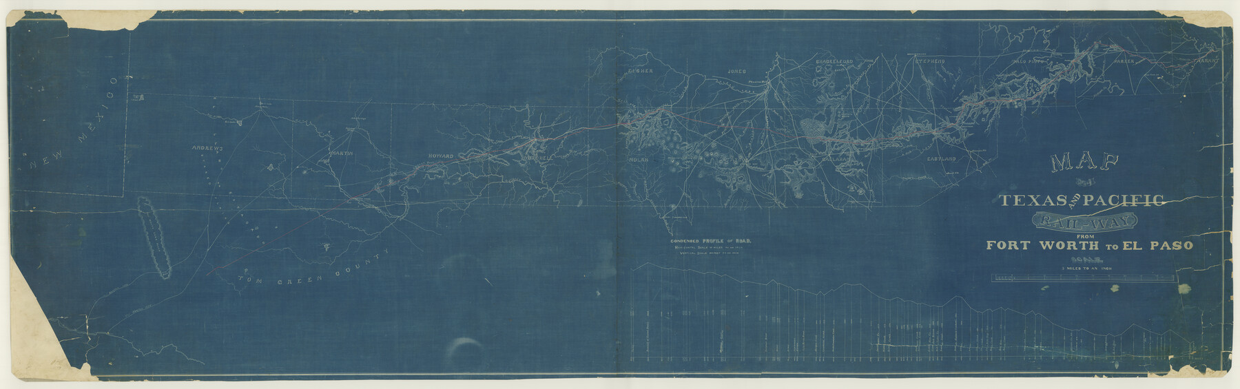
Map of the Texas & Pacific Railway from Fort Worth to El Paso
Z-2-158
-
Map/Doc
64511
-
Collection
General Map Collection
-
Object Dates
1880/12/17 (File Date)
-
Counties
Jones Parker Stephens Palo Pinto Eastland Callahan Shackelford Jones Taylor Tom Green Fisher Nolan Mitchell Howard Martin Andrews Tarrant
-
Subjects
Railroads
-
Height x Width
24.0 x 76.5 inches
61.0 x 194.3 cm
-
Medium
blueprint/diazo
-
Scale
5 miles to an inch
-
Features
Mustang Spring
Mustang Fountain
Sulphur Wells
North Concho Creek
Soda Springs
Sulphur Spring
Big Spring
Moss Spring
Signal Mountain
Giraud's Creek
Ross Creek
Rattle Snake Pass
Abram's Spring
Morgan's Creek
Cherry Creek
Wild Horse Creek
McKenrie Trail
Colorado River
Lone Wolf Creek
North Prong of Champlain's Creek
South Prong of Champlain's Creek
Hoffman's Creek
McKinney's Creek
Kuechler's Creek
Oak Creek
Fort Chadbourne
Church Peak
Valley Creek
Mountain Range
Sweetwater Mountains
Bitter Creek
Sweetwater Creek
Kill Dugan Creek
Capitola Creek
Clear Fork of Brazos River
Phantom Hill
Dead Man's Creek
Willow Creek
Buck Creek
Horsehead Creek
Rainey Creek
Red Creek
Buffalo Gap
T&P
Dry Arroyo
Salt Lake
Five Wells
Mustang Draw
Cedar Gap
Little Elm Creek
Sunflower Creek
Mountain Pass Creek
Mulberry Creek
Jim Ned Creek
Tecumseh Peaks
Caddo P.O.
West Caddo Peak
East Caddo Peak
Green Briar Creek
Belle Plain
Deep Creek Hills
Callahan City
Battle Creek
Bremen
Twin Butte Gap
Lone Butte
Mexia Creek
Baird
Powel's Ranche
Hubbard's Timbers
Mollie's Butes
Asylum Creek
College Creek
West Fork of Hubbard's Creek
Jonnie's Creek
South Fork of Mill Creek
Albany
Breckenridge
45 Mile Creek
Price's Creek
Little Sandy
Cedar Creek
Big Caddo Creek
White Flats
Leon R. River
Eastland
Wayne's Creek
Jewell P.O.
Hog Creek
Alameda P.O.
Colony Fork of Leon River
Merriman
Little Cedar
Cañon
Cole's Peak
McKane's Peaks
Russell's Creek
Evans Mountain
Strawn
South Palo Pinto
Palo Pinto Creek
Skull Bone Mountain
Cresco
Clayton Mountains
Pecan Bayou
Barton's Creek
Saline Creek
Walnut Creek
Brazos
Sunday Creek
Bill's Creek
Brazos River
Palo Pinto
Hickson Crossing
Red Bluff
Rock Creek
Dry Creek
Millsar
Grindstone Creek
Lambert
Moore's Gap
Weatherford
Patrick's Creek
Hine's P.O.
Kickapoo Creek
Earl's
Burgess Creek
Anneta
Mary's Creek
Bear Creek P.O.
Little Red Bear Creek
Cottonwood Creek
Village Creek
Ft. Worth
Tannahill
Little Fossil Creek
Fossil Creek
Summit
Ben Brook
Turkey Creek
The White San Hills
[] Cos River
Shafter's Lake (Alkali)
Part of: General Map Collection
Greer County Sketch File 8

Print $20.00
- Digital $50.00
Greer County Sketch File 8
Size 16.7 x 23.6 inches
Map/Doc 11584
Pecos County Working Sketch 122

Print $40.00
- Digital $50.00
Pecos County Working Sketch 122
1973
Size 51.9 x 36.7 inches
Map/Doc 71595
Rio Grande, Hargill Sheet

Print $20.00
- Digital $50.00
Rio Grande, Hargill Sheet
1937
Size 37.3 x 37.8 inches
Map/Doc 65109
Flight Mission No. CUG-3P, Frame 138, Kleberg County

Print $20.00
- Digital $50.00
Flight Mission No. CUG-3P, Frame 138, Kleberg County
1956
Size 18.6 x 22.4 inches
Map/Doc 86273
Flight Mission No. DQO-3K, Frame 29, Galveston County

Print $20.00
- Digital $50.00
Flight Mission No. DQO-3K, Frame 29, Galveston County
1952
Size 18.8 x 22.4 inches
Map/Doc 85070
Kinney County Working Sketch 30

Print $40.00
- Digital $50.00
Kinney County Working Sketch 30
1959
Size 52.6 x 34.7 inches
Map/Doc 70212
Hardin County Sketch File 15

Print $6.00
- Digital $50.00
Hardin County Sketch File 15
Size 9.0 x 4.9 inches
Map/Doc 25122
Flight Mission No. CLL-1N, Frame 160, Willacy County

Print $20.00
- Digital $50.00
Flight Mission No. CLL-1N, Frame 160, Willacy County
1954
Size 18.3 x 22.0 inches
Map/Doc 87051
Flight Mission No. BRE-1P, Frame 149, Nueces County

Print $20.00
- Digital $50.00
Flight Mission No. BRE-1P, Frame 149, Nueces County
1956
Size 18.3 x 22.3 inches
Map/Doc 86709
Runnels County Rolled Sketch 46

Print $20.00
- Digital $50.00
Runnels County Rolled Sketch 46
1954
Size 32.3 x 38.5 inches
Map/Doc 10622
Brewster County Working Sketch 43

Print $20.00
- Digital $50.00
Brewster County Working Sketch 43
1947
Size 33.7 x 36.2 inches
Map/Doc 67577
Clay County Boundary File 15

Print $8.00
- Digital $50.00
Clay County Boundary File 15
Size 13.3 x 8.2 inches
Map/Doc 51418
You may also like
Working Sketch in Wichita County [in northern part of county]
![91992, Working Sketch in Wichita County [in northern part of county], Twichell Survey Records](https://historictexasmaps.com/wmedia_w700/maps/91992-1.tif.jpg)
Print $20.00
- Digital $50.00
Working Sketch in Wichita County [in northern part of county]
1919
Size 38.3 x 18.5 inches
Map/Doc 91992
Dickens County Sketch File 19

Print $4.00
- Digital $50.00
Dickens County Sketch File 19
1910
Size 8.4 x 7.5 inches
Map/Doc 20982
Land Owned by the Cedar Valley Land and Cattle Co. are M.K.O.

Print $20.00
- Digital $50.00
Land Owned by the Cedar Valley Land and Cattle Co. are M.K.O.
Size 21.4 x 16.5 inches
Map/Doc 91758

Hardin County Sketch File 5

Print $5.00
- Digital $50.00
Hardin County Sketch File 5
1856
Size 9.0 x 6.6 inches
Map/Doc 25092
Andrews County Rolled Sketch 42

Print $20.00
- Digital $50.00
Andrews County Rolled Sketch 42
Size 27.3 x 36.0 inches
Map/Doc 77182
Concho County Working Sketch 11

Print $20.00
- Digital $50.00
Concho County Working Sketch 11
1951
Size 22.0 x 23.2 inches
Map/Doc 68193
Sketch showing surveys on Harbor Island in Nueces County

Print $20.00
- Digital $50.00
Sketch showing surveys on Harbor Island in Nueces County
1978
Size 46.4 x 36.0 inches
Map/Doc 2020
Sketch in Atascosa County

Print $3.00
- Digital $50.00
Sketch in Atascosa County
1890
Size 12.6 x 11.4 inches
Map/Doc 578

Map of Nacogdoches County

Print $20.00
- Digital $50.00
Map of Nacogdoches County
1846
Size 43.9 x 39.7 inches
Map/Doc 87356
The Republic County of Gonzales. December 18, 1837

Print $20.00
The Republic County of Gonzales. December 18, 1837
2020
Size 14.7 x 21.7 inches
Map/Doc 96154