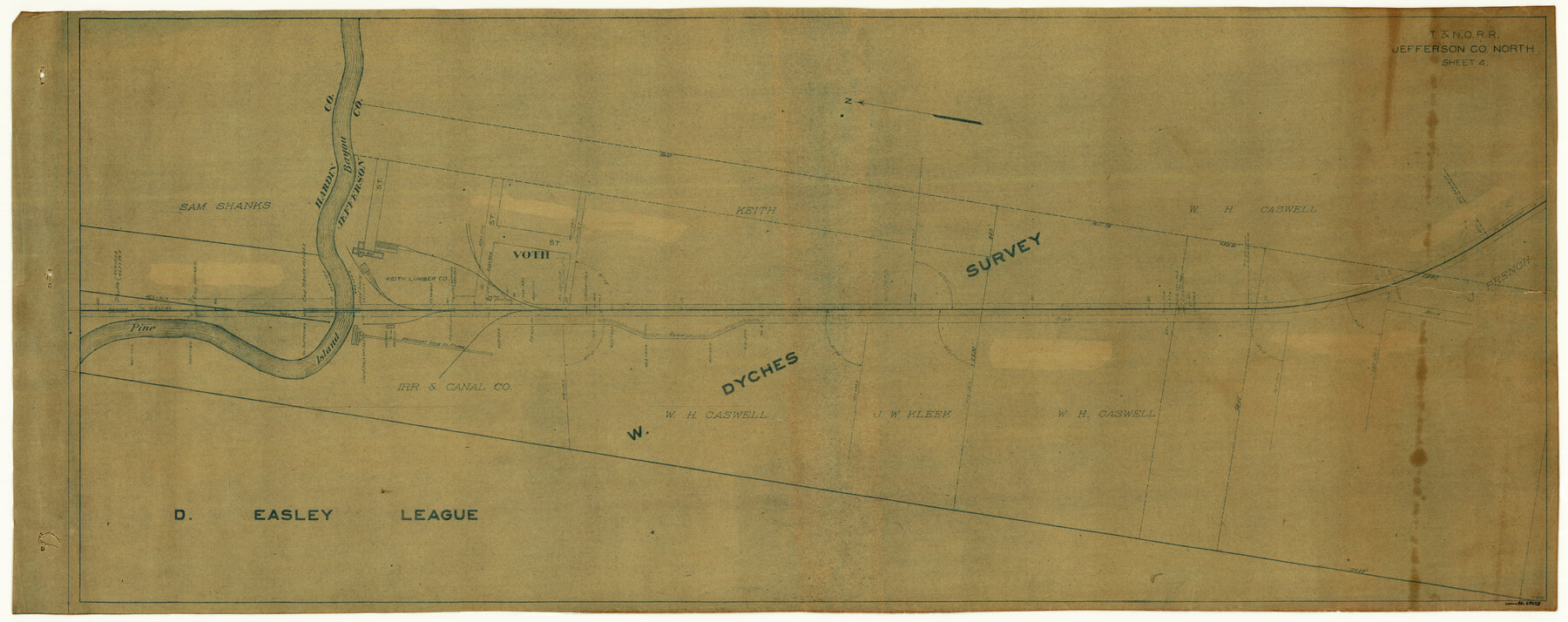
T. & N. O. R.R. Jefferson Co. North
Sheet 4
Z-2-16
-
Map/Doc
64058
-
Collection
General Map Collection
-
Object Dates
1917 (Creation Date)
-
Counties
Jefferson Hardin
-
Subjects
Railroads
-
Height x Width
13.4 x 33.5 inches
34.0 x 85.1 cm
-
Medium
blueprint/diazo
-
Comments
See 64055-64057 for other segments of the map. See 64054 (PDF) for the documents/letter that accompanied the map.
-
Features
T&NO
Pine Island Bayou
Part of: General Map Collection
Flight Mission No. DQN-1K, Frame 43, Calhoun County

Print $20.00
- Digital $50.00
Flight Mission No. DQN-1K, Frame 43, Calhoun County
1953
Size 18.6 x 22.3 inches
Map/Doc 84143
The Making of America - The Southwest

The Making of America - The Southwest
Size 20.8 x 27.5 inches
Map/Doc 95947
Anderson County Working Sketch 14

Print $20.00
- Digital $50.00
Anderson County Working Sketch 14
1933
Size 20.3 x 26.0 inches
Map/Doc 67014
[Galveston, Harrisburg & San Antonio from El Paso-Presidio county boundary to Presidio-Pecos county boundary]
![64717, [Galveston, Harrisburg & San Antonio from El Paso-Presidio county boundary to Presidio-Pecos county boundary], General Map Collection](https://historictexasmaps.com/wmedia_w700/maps/64717.tif.jpg)
Print $40.00
- Digital $50.00
[Galveston, Harrisburg & San Antonio from El Paso-Presidio county boundary to Presidio-Pecos county boundary]
Size 149.3 x 44.4 inches
Map/Doc 64717
Hardin County Sketch File 27

Print $4.00
- Digital $50.00
Hardin County Sketch File 27
Size 13.0 x 8.1 inches
Map/Doc 25151
Castro County Rolled Sketch 13A

Print $20.00
- Digital $50.00
Castro County Rolled Sketch 13A
1967
Size 20.0 x 18.9 inches
Map/Doc 5423
Andrews County Working Sketch 32

Print $20.00
- Digital $50.00
Andrews County Working Sketch 32
1990
Size 29.6 x 31.5 inches
Map/Doc 67078
Denton County Sketch File C

Print $10.00
- Digital $50.00
Denton County Sketch File C
1882
Size 10.9 x 8.3 inches
Map/Doc 20682
[Beaumont, Sour Lake and Western Ry. Right of Way and Alignment - Frisco]
![64125, [Beaumont, Sour Lake and Western Ry. Right of Way and Alignment - Frisco], General Map Collection](https://historictexasmaps.com/wmedia_w700/maps/64125.tif.jpg)
Print $20.00
- Digital $50.00
[Beaumont, Sour Lake and Western Ry. Right of Way and Alignment - Frisco]
1910
Size 20.1 x 45.9 inches
Map/Doc 64125
Haskell County Rolled Sketch 15

Print $20.00
- Digital $50.00
Haskell County Rolled Sketch 15
1991
Size 12.7 x 18.4 inches
Map/Doc 6173
Zapata County Working Sketch 9

Print $20.00
- Digital $50.00
Zapata County Working Sketch 9
1951
Size 34.9 x 18.1 inches
Map/Doc 62060
Limestone County Working Sketch 9

Print $20.00
- Digital $50.00
Limestone County Working Sketch 9
1922
Size 18.5 x 19.2 inches
Map/Doc 70559
You may also like
Flight Mission No. CUG-3P, Frame 167, Kleberg County

Print $20.00
- Digital $50.00
Flight Mission No. CUG-3P, Frame 167, Kleberg County
1956
Size 18.6 x 22.4 inches
Map/Doc 86287
Trinity River, North Extension Bazzette Sheet

Print $20.00
- Digital $50.00
Trinity River, North Extension Bazzette Sheet
1925
Size 16.3 x 24.3 inches
Map/Doc 69691
Polk County Working Sketch 5

Print $20.00
- Digital $50.00
Polk County Working Sketch 5
1926
Size 17.9 x 23.2 inches
Map/Doc 71620
Jasper County Sketch File 27

Print $22.00
- Digital $50.00
Jasper County Sketch File 27
Size 11.4 x 8.8 inches
Map/Doc 27842
Flight Mission No. CUG-1P, Frame 28, Kleberg County

Print $20.00
- Digital $50.00
Flight Mission No. CUG-1P, Frame 28, Kleberg County
1956
Size 18.6 x 22.2 inches
Map/Doc 86118
Presidio County Rolled Sketch 131A

Print $20.00
- Digital $50.00
Presidio County Rolled Sketch 131A
1992
Size 36.5 x 46.7 inches
Map/Doc 9802

Webb County Rolled Sketch D

Print $20.00
- Digital $50.00
Webb County Rolled Sketch D
1897
Size 25.4 x 40.6 inches
Map/Doc 8222
General Highway Map, Cameron County, Texas

Print $20.00
General Highway Map, Cameron County, Texas
1961
Size 18.3 x 24.7 inches
Map/Doc 79398
Comal County Sketch File 12

Print $4.00
- Digital $50.00
Comal County Sketch File 12
Size 8.4 x 11.3 inches
Map/Doc 19024
Galveston County NRC Article 33.136 Sketch 7

Print $20.00
- Digital $50.00
Galveston County NRC Article 33.136 Sketch 7
2001
Size 23.7 x 37.2 inches
Map/Doc 61589
Chambers County Rolled Sketch 21

Print $20.00
- Digital $50.00
Chambers County Rolled Sketch 21
1940
Size 40.9 x 41.0 inches
Map/Doc 8589