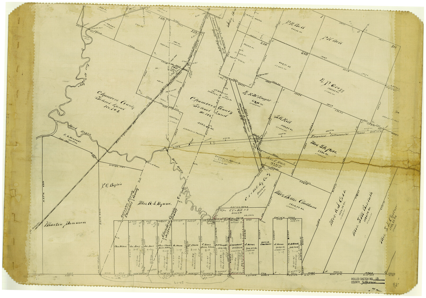
Jefferson County Rolled Sketch 13
[Sketch of Chambers County School Land surveys in Jefferson and Chambers County]
-
Map/Doc
6385
-
Collection
General Map Collection
-
Counties
Jefferson Chambers
-
Subjects
Surveying Rolled Sketch
-
Height x Width
18.8 x 27.2 inches
47.8 x 69.1 cm
-
Medium
paper, manuscript
Part of: General Map Collection
Flight Mission No. BQY-4M, Frame 60, Harris County

Print $20.00
- Digital $50.00
Flight Mission No. BQY-4M, Frame 60, Harris County
1953
Size 18.6 x 22.3 inches
Map/Doc 85269
Township No. 2 South Range No. 21 West of the Indian Meridian

Print $20.00
- Digital $50.00
Township No. 2 South Range No. 21 West of the Indian Meridian
1875
Size 19.3 x 24.4 inches
Map/Doc 75177
Flight Mission No. DCL-7C, Frame 110, Kenedy County

Print $20.00
- Digital $50.00
Flight Mission No. DCL-7C, Frame 110, Kenedy County
1943
Size 18.5 x 22.3 inches
Map/Doc 86075
Polk County Sketch File 20

Print $4.00
- Digital $50.00
Polk County Sketch File 20
Size 6.1 x 8.2 inches
Map/Doc 34167
Trinity River, Terrell Sheet/Kings Creek

Print $20.00
- Digital $50.00
Trinity River, Terrell Sheet/Kings Creek
1930
Size 42.3 x 19.7 inches
Map/Doc 65229
Hopkins County Sketch File 21

Print $24.00
- Digital $50.00
Hopkins County Sketch File 21
1871
Size 8.1 x 12.5 inches
Map/Doc 26727
Freestone County Working Sketch 34

Print $40.00
- Digital $50.00
Freestone County Working Sketch 34
2011
Size 36.5 x 59.2 inches
Map/Doc 90095
Cooke County Sketch File 27

Print $24.00
- Digital $50.00
Cooke County Sketch File 27
Size 9.8 x 8.5 inches
Map/Doc 19279
Andrews County Rolled Sketch 40

Print $20.00
- Digital $50.00
Andrews County Rolled Sketch 40
Size 37.2 x 23.0 inches
Map/Doc 77180
Flight Mission No. BRA-7M, Frame 193, Jefferson County

Print $20.00
- Digital $50.00
Flight Mission No. BRA-7M, Frame 193, Jefferson County
1953
Size 18.7 x 22.4 inches
Map/Doc 85561
La Salle County Working Sketch 7

Print $20.00
- Digital $50.00
La Salle County Working Sketch 7
1922
Size 35.0 x 36.5 inches
Map/Doc 70308
Kendall County Working Sketch 27

Print $20.00
- Digital $50.00
Kendall County Working Sketch 27
1994
Size 30.8 x 42.6 inches
Map/Doc 66699
You may also like
Hudspeth County Sketch File 51

Print $4.00
- Digital $50.00
Hudspeth County Sketch File 51
1962
Size 14.4 x 9.1 inches
Map/Doc 27074
Map and Profile of the Denison and Pacific Railway from Denison to Whitesboro

Print $40.00
- Digital $50.00
Map and Profile of the Denison and Pacific Railway from Denison to Whitesboro
1878
Size 42.5 x 57.5 inches
Map/Doc 64284
Pecos County Working Sketch 107

Print $40.00
- Digital $50.00
Pecos County Working Sketch 107
1971
Size 55.3 x 37.4 inches
Map/Doc 71580
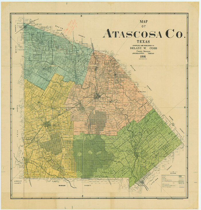
Map of Atascosa County, Texas
Print $20.00
- Digital $50.00
Map of Atascosa County, Texas
1916
Size 30.0 x 28.6 inches
Map/Doc 9006
[Sections 2-5, H. & G. N. Block 12]
![91583, [Sections 2-5, H. & G. N. Block 12], Twichell Survey Records](https://historictexasmaps.com/wmedia_w700/maps/91583-1.tif.jpg)
Print $2.00
- Digital $50.00
[Sections 2-5, H. & G. N. Block 12]
Size 12.3 x 9.2 inches
Map/Doc 91583
Amistad International Reservoir on Rio Grande 100

Print $20.00
- Digital $50.00
Amistad International Reservoir on Rio Grande 100
1950
Size 28.5 x 40.8 inches
Map/Doc 75531
Henderson County Rolled Sketch 2

Print $20.00
- Digital $50.00
Henderson County Rolled Sketch 2
1956
Size 33.7 x 26.5 inches
Map/Doc 9160
Carte Geographique, Statistique et Historique du Mexique

Print $20.00
Carte Geographique, Statistique et Historique du Mexique
1824
Size 22.3 x 28.1 inches
Map/Doc 79315
Terrell County Sketch File 36

Print $40.00
- Digital $50.00
Terrell County Sketch File 36
1958
Size 15.7 x 13.5 inches
Map/Doc 37998
Castro County Rolled Sketch 11

Print $20.00
- Digital $50.00
Castro County Rolled Sketch 11
1940
Size 20.2 x 25.3 inches
Map/Doc 5420
Orange County Rolled Sketch 13

Print $20.00
- Digital $50.00
Orange County Rolled Sketch 13
Size 19.0 x 24.2 inches
Map/Doc 7180
Geological map of the State of Pennsylvania constructed from original surveys

Print $40.00
- Digital $50.00
Geological map of the State of Pennsylvania constructed from original surveys
1858
Size 39.3 x 71.6 inches
Map/Doc 93772