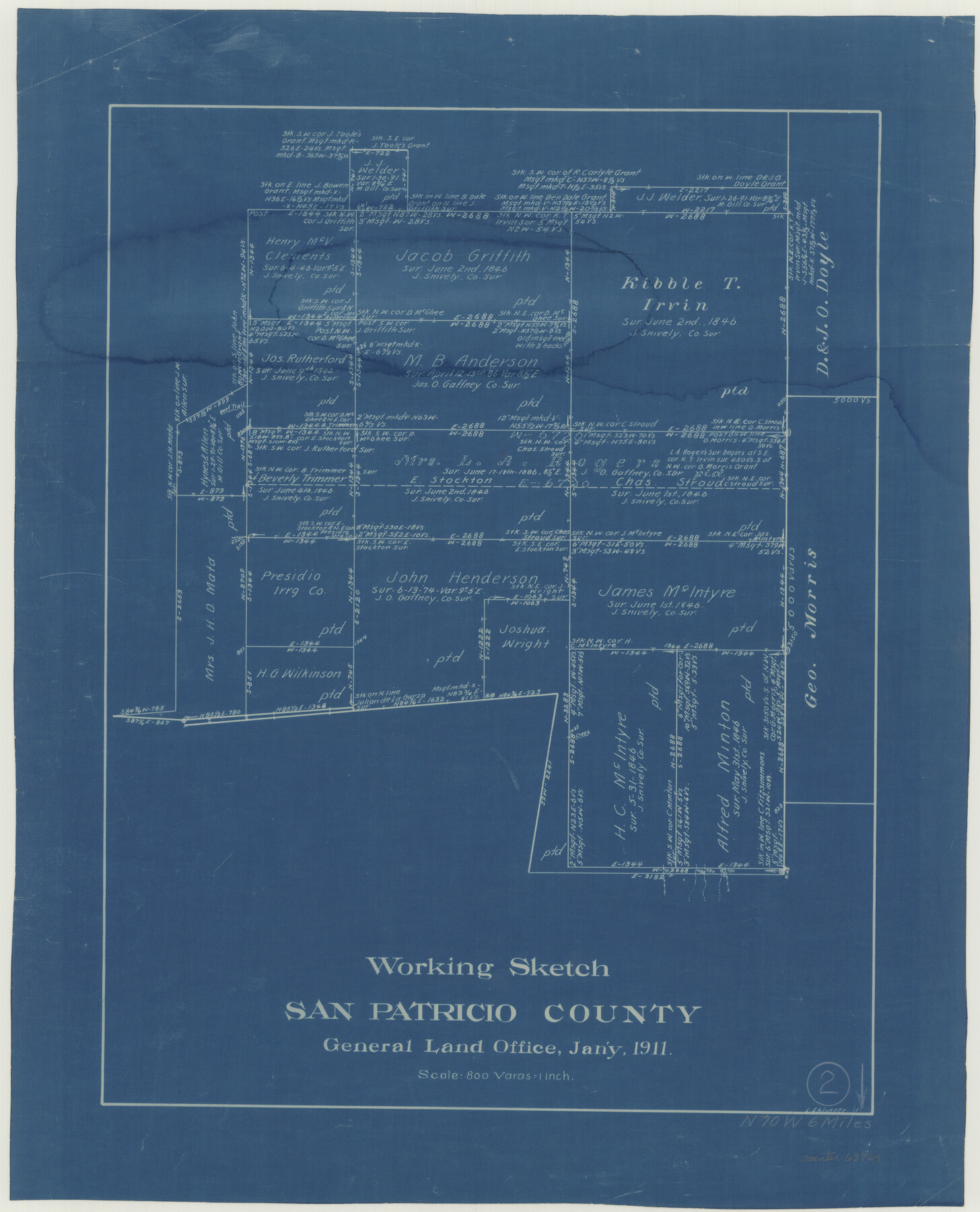
San Patricio County Working Sketch 2
-
Map/Doc
63764
-
Collection
General Map Collection
-
Object Dates
1/1911 (Creation Date)
-
People and Organizations
L. Ehlinger (Draftsman)
-
Counties
San Patricio
-
Subjects
Surveying Working Sketch
-
Height x Width
18.6 x 15.1 inches
47.2 x 38.4 cm
-
Scale
1" = 800 varas
Part of: General Map Collection
Pecos County Sketch File 109

Print $5.00
- Digital $50.00
Pecos County Sketch File 109
1982
Size 14.8 x 9.3 inches
Map/Doc 34039
Map of Michigan, Wisconsin and part of Iowa to illustrate Olney's school geography

Print $20.00
- Digital $50.00
Map of Michigan, Wisconsin and part of Iowa to illustrate Olney's school geography
1844
Size 9.5 x 12.1 inches
Map/Doc 93542
Texas, Aransas Bay, Copano Bay and St. Charles Bay

Print $40.00
- Digital $50.00
Texas, Aransas Bay, Copano Bay and St. Charles Bay
1934
Size 34.0 x 48.6 inches
Map/Doc 73434
Edwards County Working Sketch 89

Print $40.00
- Digital $50.00
Edwards County Working Sketch 89
1966
Size 49.7 x 28.8 inches
Map/Doc 68965
Current Miscellaneous File 22

Print $12.00
- Digital $50.00
Current Miscellaneous File 22
1952
Size 14.2 x 8.8 inches
Map/Doc 73876
Montgomery County Rolled Sketch 39

Print $20.00
- Digital $50.00
Montgomery County Rolled Sketch 39
1967
Size 23.8 x 27.9 inches
Map/Doc 6813
McLennan County Sketch File 4a

Print $6.00
- Digital $50.00
McLennan County Sketch File 4a
Size 9.2 x 7.9 inches
Map/Doc 31237
Flight Mission No. DQO-2K, Frame 162, Galveston County

Print $20.00
- Digital $50.00
Flight Mission No. DQO-2K, Frame 162, Galveston County
1952
Size 18.7 x 22.5 inches
Map/Doc 85051

Map of Matagorda County

Print $20.00
- Digital $50.00
Map of Matagorda County
1865
Size 26.9 x 25.0 inches
Map/Doc 3842

Armstrong County Sketch File 5

Print $40.00
- Digital $50.00
Armstrong County Sketch File 5
1887
Size 19.7 x 22.9 inches
Map/Doc 10841
You may also like

Concho County Rolled Sketch 24

Print $20.00
- Digital $50.00
Concho County Rolled Sketch 24
1964
Size 27.5 x 36.9 inches
Map/Doc 5557
Flight Mission No. DAG-21K, Frame 27, Matagorda County

Print $20.00
- Digital $50.00
Flight Mission No. DAG-21K, Frame 27, Matagorda County
1952
Size 18.4 x 22.3 inches
Map/Doc 86394
Maps showing Arkansas Central, the Helena & Corinth, and the Pine Bluff & Southwestern Railroads together forming the Texas & Northeastern Railway.

Print $20.00
Maps showing Arkansas Central, the Helena & Corinth, and the Pine Bluff & Southwestern Railroads together forming the Texas & Northeastern Railway.
1872
Size 26.8 x 29.1 inches
Map/Doc 93609
Flight Mission No. CRC-2R, Frame 200, Chambers County

Print $20.00
- Digital $50.00
Flight Mission No. CRC-2R, Frame 200, Chambers County
1956
Size 18.8 x 22.4 inches
Map/Doc 84778
Bastrop County Rolled Sketch 3

Print $20.00
- Digital $50.00
Bastrop County Rolled Sketch 3
Size 32.0 x 40.2 inches
Map/Doc 8441
Fractional Township No. 7 South Range No. 15 East of the Indian Meridian, Indian Territory

Print $20.00
- Digital $50.00
Fractional Township No. 7 South Range No. 15 East of the Indian Meridian, Indian Territory
1896
Size 19.2 x 24.3 inches
Map/Doc 75226
Map of Bowie County, Texas

Print $20.00
- Digital $50.00
Map of Bowie County, Texas
1879
Size 21.2 x 24.4 inches
Map/Doc 607
Burnet County

Print $20.00
- Digital $50.00
Burnet County
1881
Size 16.0 x 16.2 inches
Map/Doc 75785
Terrell County Sketch File 21

Print $13.00
- Digital $50.00
Terrell County Sketch File 21
1911
Size 16.4 x 10.3 inches
Map/Doc 37948
Comal County Sketch File 2

Print $22.00
- Digital $50.00
Comal County Sketch File 2
1848
Size 13.7 x 13.3 inches
Map/Doc 18997
Winkler County Working Sketch 20

Print $20.00
- Digital $50.00
Winkler County Working Sketch 20
1990
Size 22.3 x 24.0 inches
Map/Doc 72614