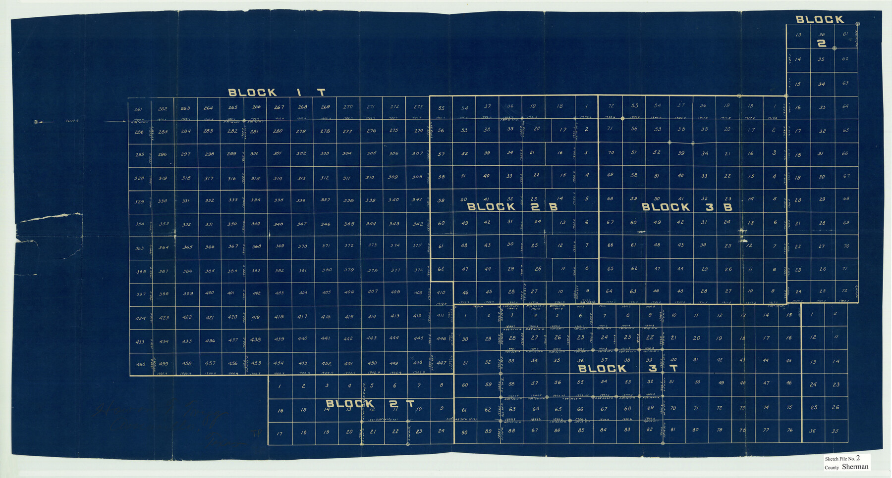
Sherman County Sketch File 2
[Sketch of G. H. & H. R.R. Co. Blocks in the south half of Sherman County and adjacent counties]
-
Map/Doc
12323
-
Collection
General Map Collection
-
Object Dates
2/6/1925 (File Date)
-
People and Organizations
Howard T. Trigg (Surveyor/Engineer)
-
Counties
Sherman Dallam Hansford Moore
-
Subjects
Surveying Sketch File
-
Height x Width
19.5 x 36.3 inches
49.5 x 92.2 cm
-
Medium
blueprint/diazo
Part of: General Map Collection
Travis County Sketch File 3

Print $4.00
- Digital $50.00
Travis County Sketch File 3
Size 12.9 x 7.9 inches
Map/Doc 38273
Howard County Working Sketch 10

Print $20.00
- Digital $50.00
Howard County Working Sketch 10
1962
Size 24.4 x 26.1 inches
Map/Doc 66278
Ochiltree County State of Texas

Print $20.00
- Digital $50.00
Ochiltree County State of Texas
1889
Size 25.5 x 19.0 inches
Map/Doc 4609
Bexar County Sketch File 33

Print $4.00
- Digital $50.00
Bexar County Sketch File 33
Size 10.7 x 8.5 inches
Map/Doc 14496
Carson County Working Sketch 5

Print $20.00
- Digital $50.00
Carson County Working Sketch 5
1979
Size 42.2 x 14.5 inches
Map/Doc 67876
Knox County Working Sketch 9

Print $20.00
- Digital $50.00
Knox County Working Sketch 9
1945
Size 33.8 x 43.3 inches
Map/Doc 70251
Hays County Sketch File 35

Print $4.00
- Digital $50.00
Hays County Sketch File 35
1873
Size 12.8 x 8.2 inches
Map/Doc 26277
[Sketch for Mineral Application 15273 - Sabine River Bed]
![65576, [Sketch for Mineral Application 15273 - Sabine River Bed], General Map Collection](https://historictexasmaps.com/wmedia_w700/maps/65576.tif.jpg)
Print $20.00
- Digital $50.00
[Sketch for Mineral Application 15273 - Sabine River Bed]
1926
Size 45.4 x 28.1 inches
Map/Doc 65576
Flight Mission No. DQN-1K, Frame 45, Calhoun County

Print $20.00
- Digital $50.00
Flight Mission No. DQN-1K, Frame 45, Calhoun County
1953
Size 15.8 x 15.6 inches
Map/Doc 84145
Flight Mission No. DQN-3K, Frame 69, Calhoun County

Print $20.00
- Digital $50.00
Flight Mission No. DQN-3K, Frame 69, Calhoun County
1953
Size 18.5 x 22.3 inches
Map/Doc 84360
Edwards County Working Sketch 27

Print $20.00
- Digital $50.00
Edwards County Working Sketch 27
1944
Size 27.7 x 23.9 inches
Map/Doc 68903
Right of Way and Track Map, Houston & Texas Central R.R. operated by the T. and N. O. R.R., Fort Worth Branch

Print $40.00
- Digital $50.00
Right of Way and Track Map, Houston & Texas Central R.R. operated by the T. and N. O. R.R., Fort Worth Branch
1918
Size 31.7 x 56.8 inches
Map/Doc 64784
You may also like
New Map of Greater San Antonio

Print $20.00
- Digital $50.00
New Map of Greater San Antonio
1941
Size 24.5 x 19.7 inches
Map/Doc 95954

Eastland County Sketch File 18

Print $20.00
- Digital $50.00
Eastland County Sketch File 18
1912
Size 17.3 x 15.5 inches
Map/Doc 11414
Township 5 North Range 13 West, North Western District, Louisiana

Print $20.00
- Digital $50.00
Township 5 North Range 13 West, North Western District, Louisiana
1885
Size 19.8 x 24.7 inches
Map/Doc 65865
[John S. Stephens Blk. S2, Lgs. 174-177, 186-193, 201-209]
![89984, [John S. Stephens Blk. S2, Lgs. 174-177, 186-193, 201-209], Twichell Survey Records](https://historictexasmaps.com/wmedia_w700/maps/89984-1.tif.jpg)
Print $2.00
- Digital $50.00
[John S. Stephens Blk. S2, Lgs. 174-177, 186-193, 201-209]
1912
Size 11.4 x 8.8 inches
Map/Doc 89984
Nueces County Rolled Sketch 66

Print $46.00
- Digital $50.00
Nueces County Rolled Sketch 66
1979
Size 26.1 x 37.4 inches
Map/Doc 9608
Hutchinson County Sketch File 48

Print $38.00
- Digital $50.00
Hutchinson County Sketch File 48
1989
Size 11.2 x 8.8 inches
Map/Doc 27400
Hardin County Sketch File 64

Print $24.00
- Digital $50.00
Hardin County Sketch File 64
1936
Size 24.5 x 25.6 inches
Map/Doc 11638
Crane County Working Sketch 32

Print $20.00
- Digital $50.00
Crane County Working Sketch 32
1984
Size 37.6 x 43.1 inches
Map/Doc 68309
Flight Mission No. DIX-8P, Frame 91, Aransas County

Print $20.00
- Digital $50.00
Flight Mission No. DIX-8P, Frame 91, Aransas County
1956
Size 18.5 x 22.4 inches
Map/Doc 83916
[Surveys between the Sabine River and Little Cypress Creek]
![139, [Surveys between the Sabine River and Little Cypress Creek], General Map Collection](https://historictexasmaps.com/wmedia_w700/maps/139.tif.jpg)
Print $3.00
- Digital $50.00
[Surveys between the Sabine River and Little Cypress Creek]
1840
Size 9.3 x 13.0 inches
Map/Doc 139
Llano County Working Sketch 1

Print $20.00
- Digital $50.00
Llano County Working Sketch 1
1938
Size 19.5 x 19.2 inches
Map/Doc 70619