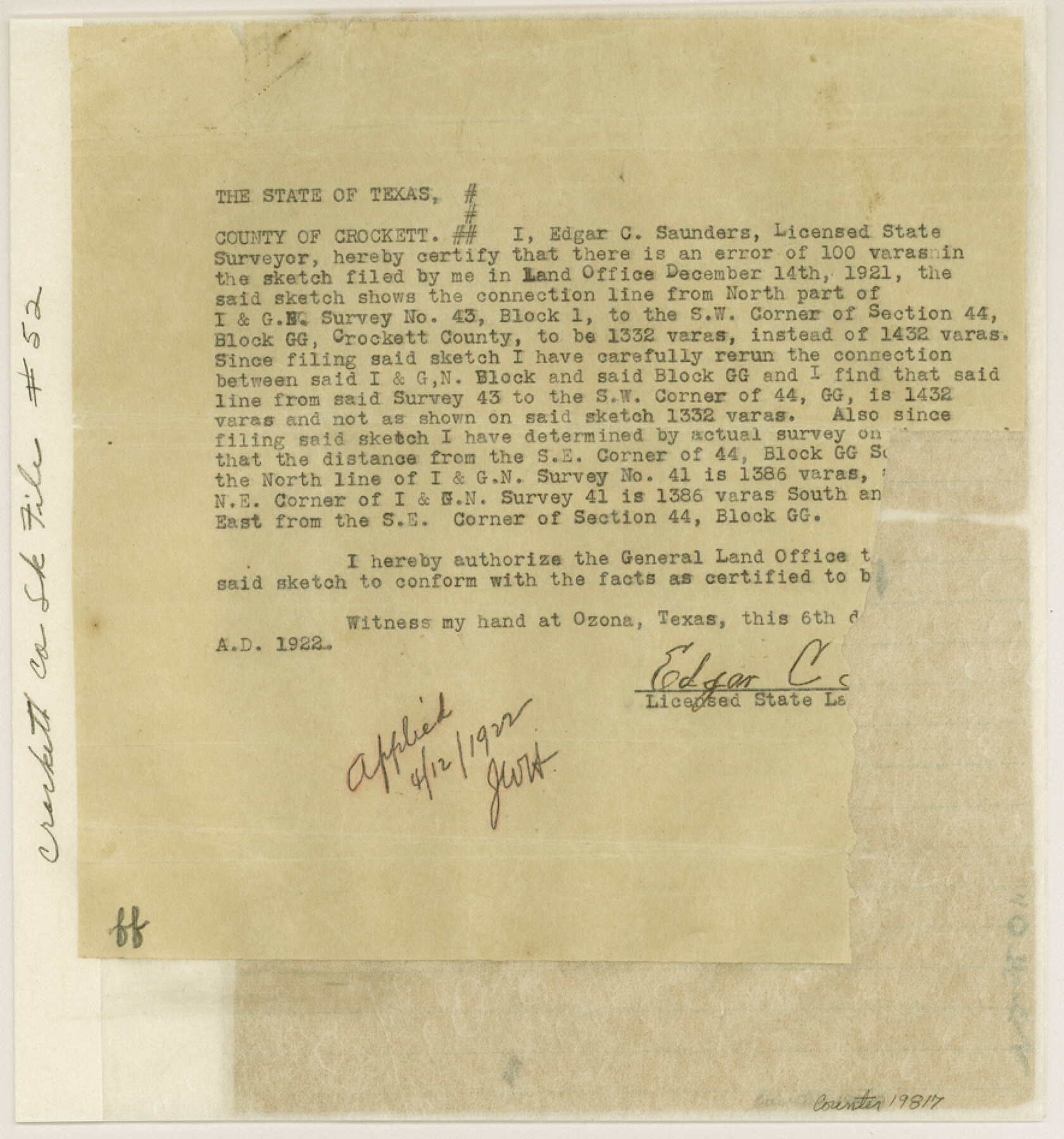
Crockett County Sketch File 52
[Letter of correction and sketch]
-
Map/Doc
19817
-
Collection
General Map Collection
-
People and Organizations
Edgar C. Saunders (Surveyor/Engineer)
-
Counties
Crockett
-
Subjects
Surveying Sketch File
-
Height x Width
9.5 x 8.8 inches
24.1 x 22.4 cm
-
Medium
multi-page, multi-format
Part of: General Map Collection
Aransas County Sketch File 7

Print $4.00
- Digital $50.00
Aransas County Sketch File 7
Size 12.7 x 7.9 inches
Map/Doc 13112
Blanco County Boundary File 8

Print $20.00
- Digital $50.00
Blanco County Boundary File 8
Size 20.1 x 11.1 inches
Map/Doc 50575
Jefferson County Rolled Sketch 46

Print $2.00
- Digital $50.00
Jefferson County Rolled Sketch 46
1969
Size 12.3 x 5.9 inches
Map/Doc 10198
Houston County Working Sketch 5

Print $20.00
- Digital $50.00
Houston County Working Sketch 5
Size 24.9 x 28.1 inches
Map/Doc 66235
Texas Official Travel Map

Digital $50.00
Texas Official Travel Map
Size 33.4 x 36.1 inches
Map/Doc 94304
El Paso County Working Sketch 5

Print $20.00
- Digital $50.00
El Paso County Working Sketch 5
1916
Size 21.5 x 37.2 inches
Map/Doc 69027

Boundary and Ownership map, Laguna Atascosa National Wildlife Refuge, Cameron and Willacy Counties, Texas

Print $40.00
- Digital $50.00
Boundary and Ownership map, Laguna Atascosa National Wildlife Refuge, Cameron and Willacy Counties, Texas
1968
Size 73.9 x 43.2 inches
Map/Doc 60395
Intracoastal Waterway in Texas - Corpus Christi to Point Isabel including Arroyo Colorado to Mo. Pac. R.R. Bridge Near Harlingen

Print $20.00
- Digital $50.00
Intracoastal Waterway in Texas - Corpus Christi to Point Isabel including Arroyo Colorado to Mo. Pac. R.R. Bridge Near Harlingen
1933
Size 28.2 x 40.7 inches
Map/Doc 61855
Brown County Sketch File 5

Print $40.00
- Digital $50.00
Brown County Sketch File 5
1858
Size 17.9 x 15.8 inches
Map/Doc 11017
Blanco County Rolled Sketch 20

Print $36.00
- Digital $50.00
Blanco County Rolled Sketch 20
Size 30.7 x 17.0 inches
Map/Doc 87343
Kleberg County Rolled Sketch 10-29

Print $20.00
- Digital $50.00
Kleberg County Rolled Sketch 10-29
1952
Size 37.6 x 33.8 inches
Map/Doc 9373
You may also like
Burleson County Working Sketch 25

Print $20.00
- Digital $50.00
Burleson County Working Sketch 25
1981
Size 27.9 x 31.0 inches
Map/Doc 67744
[Surveying Sketch of M. Farley, R. Word, S. S. Hervey, et al in Kleberg County, Texas]
![10783, [Surveying Sketch of M. Farley, R. Word, S. S. Hervey, et al in Kleberg County, Texas], Maddox Collection](https://historictexasmaps.com/wmedia_w700/maps/10783.tif.jpg)
Print $20.00
- Digital $50.00
[Surveying Sketch of M. Farley, R. Word, S. S. Hervey, et al in Kleberg County, Texas]
Size 23.2 x 40.6 inches
Map/Doc 10783
The Republic County of Victoria. February 2, 1842

Print $20.00
The Republic County of Victoria. February 2, 1842
2020
Size 24.3 x 21.7 inches
Map/Doc 96299
Calhoun County Aerial Photograph Index Sheet 2

Print $20.00
- Digital $50.00
Calhoun County Aerial Photograph Index Sheet 2
1953
Size 24.1 x 19.8 inches
Map/Doc 83671
Clay County Sketch File 27

Print $20.00
- Digital $50.00
Clay County Sketch File 27
1900
Size 18.8 x 16.5 inches
Map/Doc 11089
Lubbock Irrigation Co. San Augustine County School Land Lubbock County, Texas

Print $20.00
- Digital $50.00
Lubbock Irrigation Co. San Augustine County School Land Lubbock County, Texas
Size 37.5 x 37.9 inches
Map/Doc 89894

Jim Hogg County Working Sketch 1

Print $20.00
- Digital $50.00
Jim Hogg County Working Sketch 1
1933
Size 30.4 x 25.3 inches
Map/Doc 66587
Matagorda County Boundary File 1a

Print $8.00
- Digital $50.00
Matagorda County Boundary File 1a
Size 14.2 x 8.6 inches
Map/Doc 56889
Gregg County Rolled Sketch MHH1

Print $40.00
- Digital $50.00
Gregg County Rolled Sketch MHH1
1935
Size 167.4 x 23.1 inches
Map/Doc 9064
Gaines County Rolled Sketch 30

Print $20.00
- Digital $50.00
Gaines County Rolled Sketch 30
1962
Size 19.4 x 26.3 inches
Map/Doc 5943
Flight Mission No. BRE-2P, Frame 98, Nueces County

Print $20.00
- Digital $50.00
Flight Mission No. BRE-2P, Frame 98, Nueces County
1956
Size 18.5 x 22.4 inches
Map/Doc 86783