Cameron County Rolled Sketch 13
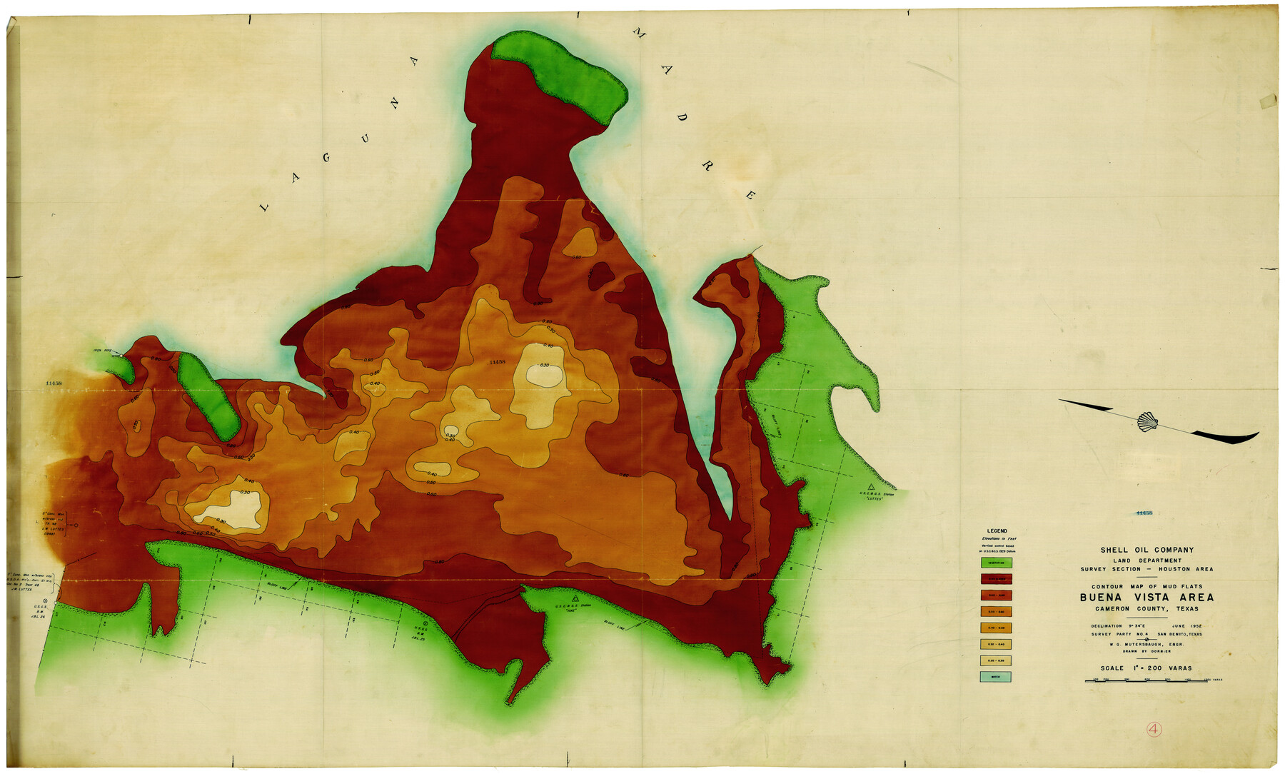
Contour Map of Mud Flats, Buena Vista Area, Cameron County, Texas
-
Map/Doc
61787
-
Collection
General Map Collection
-
Object Dates
6/1952 (Creation Date)
-
People and Organizations
Shell Oil Company (Publisher)
W.G. Mutersbaugh (Surveyor/Engineer)
-
Counties
Cameron
-
Subjects
Surveying Rolled Sketch
-
Height x Width
37.7 x 62.7 inches
95.8 x 159.3 cm
-
Scale
1" = 200 varas
-
Comments
Filed for information only.
For elevation map of the same area, see 8567.
Related maps
Cameron County Rolled Sketch 13

Print $40.00
- Digital $50.00
Cameron County Rolled Sketch 13
1952
Size 39.2 x 62.1 inches
Map/Doc 8567
Part of: General Map Collection
Hidalgo County Sketch File 19

Print $42.00
- Digital $50.00
Hidalgo County Sketch File 19
1983
Size 11.3 x 8.9 inches
Map/Doc 26448
Midland County Working Sketch 1

Print $20.00
- Digital $50.00
Midland County Working Sketch 1
Size 26.8 x 8.7 inches
Map/Doc 70981

Montgomery County

Print $20.00
- Digital $50.00
Montgomery County
1855
Size 26.5 x 28.3 inches
Map/Doc 3889
Stephens County Working Sketch 37

Print $40.00
- Digital $50.00
Stephens County Working Sketch 37
1983
Size 42.9 x 67.7 inches
Map/Doc 63980
Leon County Rolled Sketch 35

Print $20.00
- Digital $50.00
Leon County Rolled Sketch 35
2018
Size 30.7 x 21.3 inches
Map/Doc 95288
Map of the River Sabine shewing that portion of the Boundary between the Republic of Texas and the United States included between Logan's Ferry and the Intersection of the 32nd degree of N. Latitude with the Western bank of Sabine River

Print $20.00
- Digital $50.00
Map of the River Sabine shewing that portion of the Boundary between the Republic of Texas and the United States included between Logan's Ferry and the Intersection of the 32nd degree of N. Latitude with the Western bank of Sabine River
1842
Size 19.2 x 27.3 inches
Map/Doc 65410
Leon County Working Sketch 56

Print $20.00
- Digital $50.00
Leon County Working Sketch 56
1991
Size 32.7 x 26.4 inches
Map/Doc 70456
PSL Field Notes for Blocks 1, 5, 6, and 7 in El Paso County and Blocks 2, 3, 4, 8, 9, 10, 11, 12, 13, and 14 in Hudspeth County

PSL Field Notes for Blocks 1, 5, 6, and 7 in El Paso County and Blocks 2, 3, 4, 8, 9, 10, 11, 12, 13, and 14 in Hudspeth County
Map/Doc 81653
Map of Jackson County Texas

Print $20.00
- Digital $50.00
Map of Jackson County Texas
1840
Size 29.6 x 23.2 inches
Map/Doc 3708
Capitol Land Reservation

Print $20.00
- Digital $50.00
Capitol Land Reservation
1880
Size 43.7 x 34.2 inches
Map/Doc 10745
Map of Texas from the most recent authorities

Print $20.00
- Digital $50.00
Map of Texas from the most recent authorities
1845
Map/Doc 93945
You may also like
Childress County

Print $20.00
- Digital $50.00
Childress County
1921
Size 43.8 x 32.6 inches
Map/Doc 66753
Hale County Boundary File 8

Print $60.00
- Digital $50.00
Hale County Boundary File 8
Size 11.8 x 9.0 inches
Map/Doc 54080
Real County Working Sketch 21

Print $20.00
- Digital $50.00
Real County Working Sketch 21
1944
Size 24.8 x 35.7 inches
Map/Doc 71913
Flight Mission No. CUG-3P, Frame 32, Kleberg County

Print $20.00
- Digital $50.00
Flight Mission No. CUG-3P, Frame 32, Kleberg County
1956
Size 18.8 x 22.3 inches
Map/Doc 86237
General Highway Map. Detail of Cities and Towns in Potter County, Texas [Amarillo and vicinity]
![79221, General Highway Map. Detail of Cities and Towns in Potter County, Texas [Amarillo and vicinity], Texas State Library and Archives](https://historictexasmaps.com/wmedia_w700/maps/79221.tif.jpg)
Print $20.00
General Highway Map. Detail of Cities and Towns in Potter County, Texas [Amarillo and vicinity]
1940
Size 24.6 x 18.2 inches
Map/Doc 79221
The Republic County of San Patricio. Proposed, Late Fall 1837

Print $20.00
The Republic County of San Patricio. Proposed, Late Fall 1837
2020
Size 17.8 x 21.7 inches
Map/Doc 96273
Map of Jones County West of the Clearfork of the Brazos River Young - East of it Milam - Land District

Print $20.00
- Digital $50.00
Map of Jones County West of the Clearfork of the Brazos River Young - East of it Milam - Land District
1859
Size 22.0 x 26.5 inches
Map/Doc 3741
Newton County Sketch File 6

Print $4.00
- Digital $50.00
Newton County Sketch File 6
1872
Size 12.4 x 7.9 inches
Map/Doc 32372
State Land for Sale on Mustang Island

Print $20.00
- Digital $50.00
State Land for Sale on Mustang Island
1910
Size 20.0 x 29.5 inches
Map/Doc 91493
[Blocks M17, M18, M23, XO2, L, Z, and Block 47, Sections 18-25]
![91241, [Blocks M17, M18, M23, XO2, L, Z, and Block 47, Sections 18-25], Twichell Survey Records](https://historictexasmaps.com/wmedia_w700/maps/91241-1.tif.jpg)
Print $20.00
- Digital $50.00
[Blocks M17, M18, M23, XO2, L, Z, and Block 47, Sections 18-25]
Size 32.3 x 26.2 inches
Map/Doc 91241
Harbor Pass and Bar at Brazos Santiago, Texas

Print $20.00
- Digital $50.00
Harbor Pass and Bar at Brazos Santiago, Texas
1879
Size 18.1 x 27.4 inches
Map/Doc 73002
Medina County Rolled Sketch 6

Print $40.00
- Digital $50.00
Medina County Rolled Sketch 6
1930
Size 51.1 x 45.2 inches
Map/Doc 9506