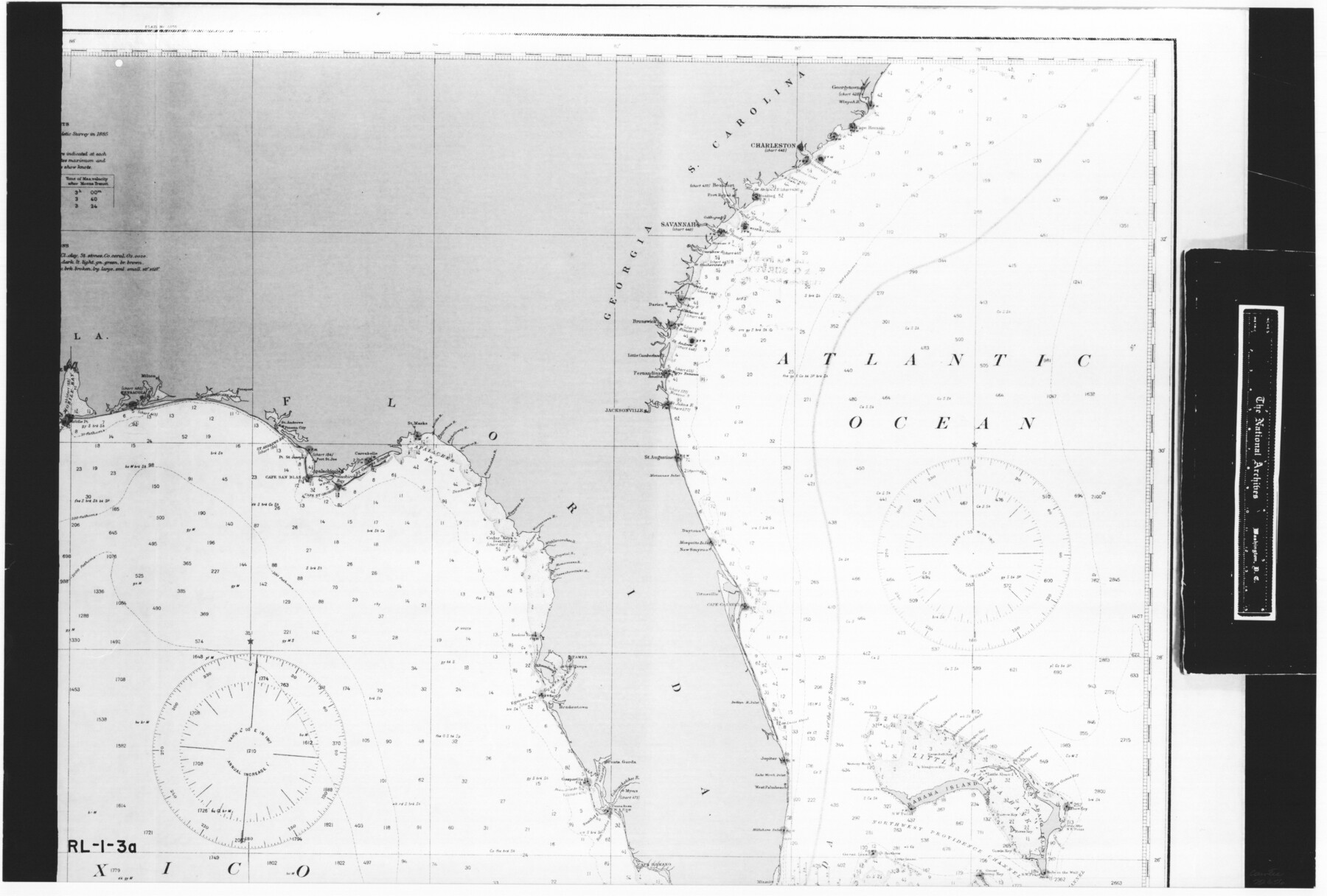
Gulf of Mexico
RL-1-3a
-
Map/Doc
72656
-
Collection
General Map Collection
-
Object Dates
1908 (Creation Date)
-
People and Organizations
Coast and Geodetic Survey (Publisher)
Coast and Geodetic Survey (Compiler)
-
Subjects
Gulf of Mexico Nautical Charts
-
Height x Width
18.3 x 27.1 inches
46.5 x 68.8 cm
-
Comments
B/W photostat copy from National Archives in multiple pieces. Chart No. 1007, Edition 4, July 1908
Part of: General Map Collection
Flight Mission No. CUG-3P, Frame 169, Kleberg County

Print $20.00
- Digital $50.00
Flight Mission No. CUG-3P, Frame 169, Kleberg County
1956
Size 18.5 x 22.2 inches
Map/Doc 86289
Brewster County Rolled Sketch 111

Print $20.00
- Digital $50.00
Brewster County Rolled Sketch 111
1962
Size 32.2 x 44.7 inches
Map/Doc 8512
Presidio County Sketch File C

Print $40.00
- Digital $50.00
Presidio County Sketch File C
Size 12.9 x 12.2 inches
Map/Doc 34426
Clay County Sketch File 12

Print $4.00
- Digital $50.00
Clay County Sketch File 12
1873
Size 13.0 x 8.2 inches
Map/Doc 18411
Refugio County Working Sketch 2

Print $20.00
- Digital $50.00
Refugio County Working Sketch 2
1927
Size 17.6 x 19.4 inches
Map/Doc 63511
Real County Working Sketch 80

Print $20.00
- Digital $50.00
Real County Working Sketch 80
1984
Size 37.9 x 43.3 inches
Map/Doc 71972
Webb County Sketch File F

Print $6.00
- Digital $50.00
Webb County Sketch File F
1900
Size 10.7 x 15.1 inches
Map/Doc 39699
Grayson County Fannin District

Print $20.00
- Digital $50.00
Grayson County Fannin District
1885
Size 43.5 x 39.4 inches
Map/Doc 66840
Trinity County Working Sketch 1

Print $20.00
- Digital $50.00
Trinity County Working Sketch 1
1904
Size 17.1 x 12.3 inches
Map/Doc 69449
Harrison County Sketch File 21

Print $20.00
- Digital $50.00
Harrison County Sketch File 21
1892
Size 20.2 x 25.7 inches
Map/Doc 11694
Hale County Rolled Sketch 6

Print $20.00
- Digital $50.00
Hale County Rolled Sketch 6
1903
Size 35.0 x 28.9 inches
Map/Doc 6045
Scurry County Sketch File 6

Print $14.00
- Digital $50.00
Scurry County Sketch File 6
2002
Size 11.2 x 8.7 inches
Map/Doc 76370
You may also like
Hood County Working Sketch 2

Print $20.00
- Digital $50.00
Hood County Working Sketch 2
1956
Size 20.5 x 25.5 inches
Map/Doc 66196
Presidio County Rolled Sketch 40

Print $20.00
- Digital $50.00
Presidio County Rolled Sketch 40
1907
Size 16.5 x 21.5 inches
Map/Doc 7337
Deaf Smith County Working Sketch 3

Print $40.00
- Digital $50.00
Deaf Smith County Working Sketch 3
1951
Size 61.4 x 22.3 inches
Map/Doc 68643
The Republic County of Austin. January 10, 1839

Print $20.00
The Republic County of Austin. January 10, 1839
2020
Size 7.0 x 22.0 inches
Map/Doc 96083
General Highway Map. Detail of Cities and Towns in Hale County, Texas [Plainview and vicinity]
![79109, General Highway Map. Detail of Cities and Towns in Hale County, Texas [Plainview and vicinity], Texas State Library and Archives](https://historictexasmaps.com/wmedia_w700/maps/79109.tif.jpg)
Print $20.00
General Highway Map. Detail of Cities and Towns in Hale County, Texas [Plainview and vicinity]
1940
Size 25.0 x 18.5 inches
Map/Doc 79109
Frio County Working Sketch 17

Print $20.00
- Digital $50.00
Frio County Working Sketch 17
1980
Size 14.4 x 16.8 inches
Map/Doc 69291
Archer County Working Sketch 14

Print $20.00
- Digital $50.00
Archer County Working Sketch 14
1940
Size 23.3 x 24.3 inches
Map/Doc 67155
Amistad International Reservoir on Rio Grande 70a

Print $20.00
- Digital $50.00
Amistad International Reservoir on Rio Grande 70a
1949
Size 28.5 x 39.5 inches
Map/Doc 73357
Harrison County Sketch File 8

Print $20.00
- Digital $50.00
Harrison County Sketch File 8
1861
Size 17.3 x 15.9 inches
Map/Doc 11685
Galveston County Sketch File 64

Print $44.00
- Digital $50.00
Galveston County Sketch File 64
1984
Size 31.5 x 25.5 inches
Map/Doc 11542
Translations of Titles issued under the Second Contract [500 Families] of Stephen F. Austin with the Government of Coahuila & Texas - Volume 1
![94546, Translations of Titles issued under the Second Contract [500 Families] of Stephen F. Austin with the Government of Coahuila & Texas - Volume 1, Historical Volumes](https://historictexasmaps.com/wmedia_w700/pdf_converted_jpg/qi_pdf_thumbnail_39135.jpg)
Translations of Titles issued under the Second Contract [500 Families] of Stephen F. Austin with the Government of Coahuila & Texas - Volume 1
1840
Map/Doc 94546
Schleicher County Sketch File 20

Print $20.00
- Digital $50.00
Schleicher County Sketch File 20
1936
Size 16.8 x 17.4 inches
Map/Doc 12301