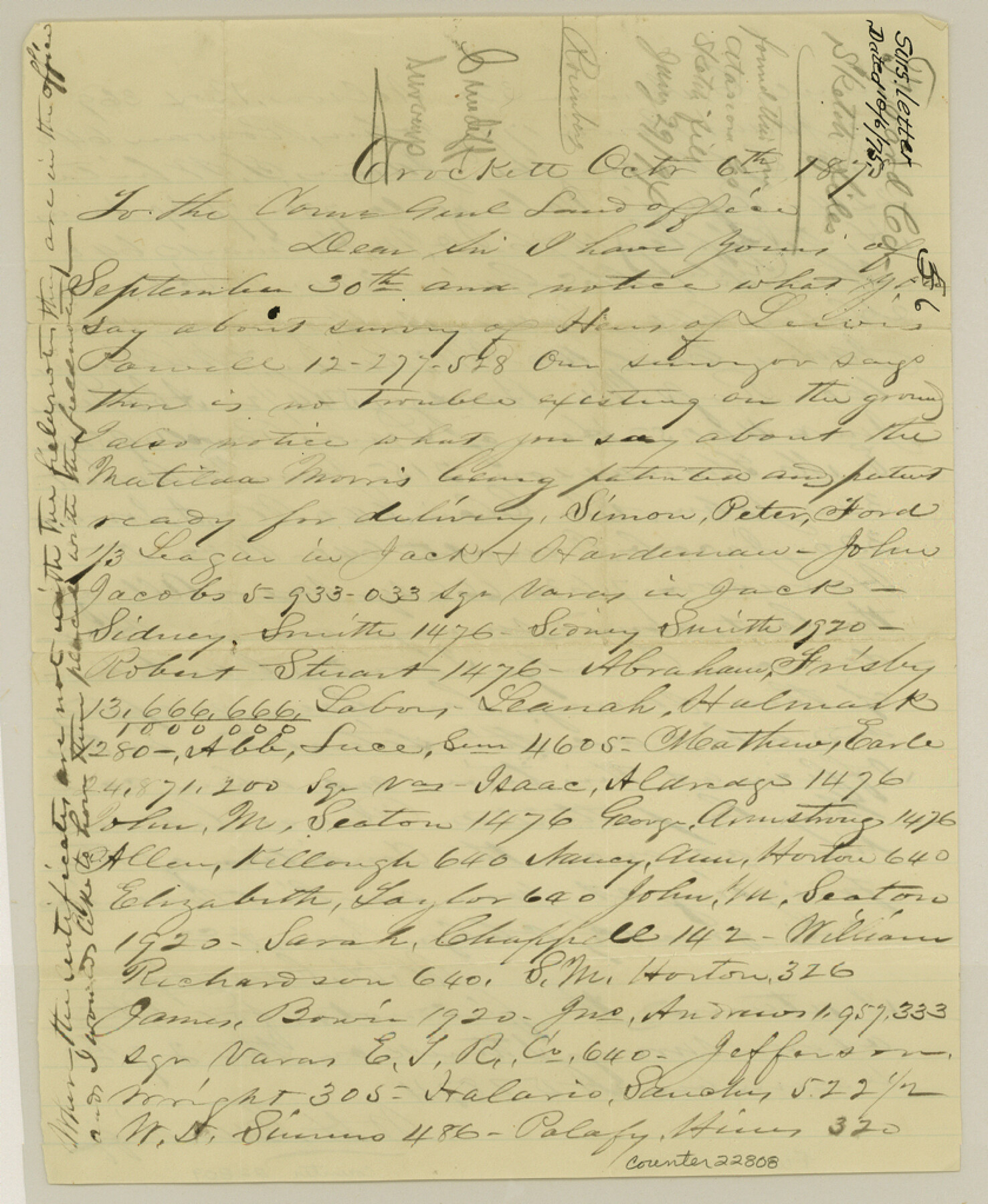
Foard County Sketch File 6
[Letter from surveyor to Commissioner of the GLO]
-
Map/Doc
22808
-
Collection
General Map Collection
-
Object Dates
1875/10/6 (Creation Date)
-
People and Organizations
W.H. Cundiff (Surveyor/Engineer)
-
Counties
Foard
-
Subjects
Surveying Sketch File
-
Height x Width
10.2 x 8.4 inches
25.9 x 21.3 cm
-
Medium
paper, manuscript
Part of: General Map Collection
Upton County Rolled Sketch 41

Print $20.00
- Digital $50.00
Upton County Rolled Sketch 41
Size 27.4 x 40.8 inches
Map/Doc 8080
Donley County Boundary File 7

Print $31.00
- Digital $50.00
Donley County Boundary File 7
Size 11.3 x 8.6 inches
Map/Doc 52640
Stonewall County Sketch File X

Print $20.00
- Digital $50.00
Stonewall County Sketch File X
1901
Size 25.8 x 18.1 inches
Map/Doc 12378
Roberts County Working Sketch 1

Print $20.00
- Digital $50.00
Roberts County Working Sketch 1
1922
Size 17.6 x 17.7 inches
Map/Doc 63527
Mills County Sketch File 18

Print $4.00
- Digital $50.00
Mills County Sketch File 18
1872
Size 12.1 x 8.1 inches
Map/Doc 31668
Map of Midland County

Print $20.00
- Digital $50.00
Map of Midland County
1901
Size 43.9 x 38.3 inches
Map/Doc 7825
Parker County Working Sketch 9

Print $20.00
- Digital $50.00
Parker County Working Sketch 9
1958
Map/Doc 71459
Navarro County Sketch File 16

Print $24.00
- Digital $50.00
Navarro County Sketch File 16
1902
Size 9.7 x 6.3 inches
Map/Doc 32330
Flight Mission No. DQN-2K, Frame 24, Calhoun County

Print $20.00
- Digital $50.00
Flight Mission No. DQN-2K, Frame 24, Calhoun County
1953
Size 18.6 x 22.2 inches
Map/Doc 84231
Map showing the environs of Brazos Island, Texas

Print $20.00
- Digital $50.00
Map showing the environs of Brazos Island, Texas
Size 18.2 x 25.0 inches
Map/Doc 72925
Polk County Sketch File 23A

Print $20.00
- Digital $50.00
Polk County Sketch File 23A
Size 23.4 x 24.3 inches
Map/Doc 12192
Pecos County Rolled Sketch 188

Print $40.00
- Digital $50.00
Pecos County Rolled Sketch 188
1984
Size 59.4 x 43.5 inches
Map/Doc 9753
You may also like
The Buffalo Bayou, Brazos and Colorado Railroad (BBB&C)

The Buffalo Bayou, Brazos and Colorado Railroad (BBB&C)
2022
Size 8.5 x 11.0 inches
Map/Doc 97088
Montgomery County Sketch File 33A

Print $20.00
- Digital $50.00
Montgomery County Sketch File 33A
1948
Size 21.3 x 28.3 inches
Map/Doc 42124

Cottle County Sketch File KN

Print $20.00
- Digital $50.00
Cottle County Sketch File KN
Size 18.8 x 25.2 inches
Map/Doc 11203
Topography and water depth as shown by the U.S. Coast Survey of 1888

Print $20.00
- Digital $50.00
Topography and water depth as shown by the U.S. Coast Survey of 1888
1890
Size 17.0 x 18.8 inches
Map/Doc 390
[Blocks 44, 6T, 26, B10, and B12]
![91528, [Blocks 44, 6T, 26, B10, and B12], Twichell Survey Records](https://historictexasmaps.com/wmedia_w700/maps/91528-1.tif.jpg)
Print $20.00
- Digital $50.00
[Blocks 44, 6T, 26, B10, and B12]
Size 19.7 x 15.8 inches
Map/Doc 91528
Hudspeth County Sketch File AQ1

Print $4.00
- Digital $50.00
Hudspeth County Sketch File AQ1
1902
Size 10.9 x 8.7 inches
Map/Doc 26922
Starr County Sketch File 14

Print $40.00
- Digital $50.00
Starr County Sketch File 14
Size 23.8 x 46.0 inches
Map/Doc 4626
Reeves County Sketch File 9

Print $20.00
- Digital $50.00
Reeves County Sketch File 9
Size 46.3 x 38.2 inches
Map/Doc 10587
Map of the River Sabine from Logan's Ferry to 32nd Degree of North Latitude

Print $20.00
Map of the River Sabine from Logan's Ferry to 32nd Degree of North Latitude
1841
Size 21.4 x 27.8 inches
Map/Doc 88902
Culberson County Sketch File 25

Print $6.00
- Digital $50.00
Culberson County Sketch File 25
Size 11.2 x 8.8 inches
Map/Doc 20259
Yoakum County Sketch File 9

Print $20.00
- Digital $50.00
Yoakum County Sketch File 9
Size 14.1 x 8.9 inches
Map/Doc 40753