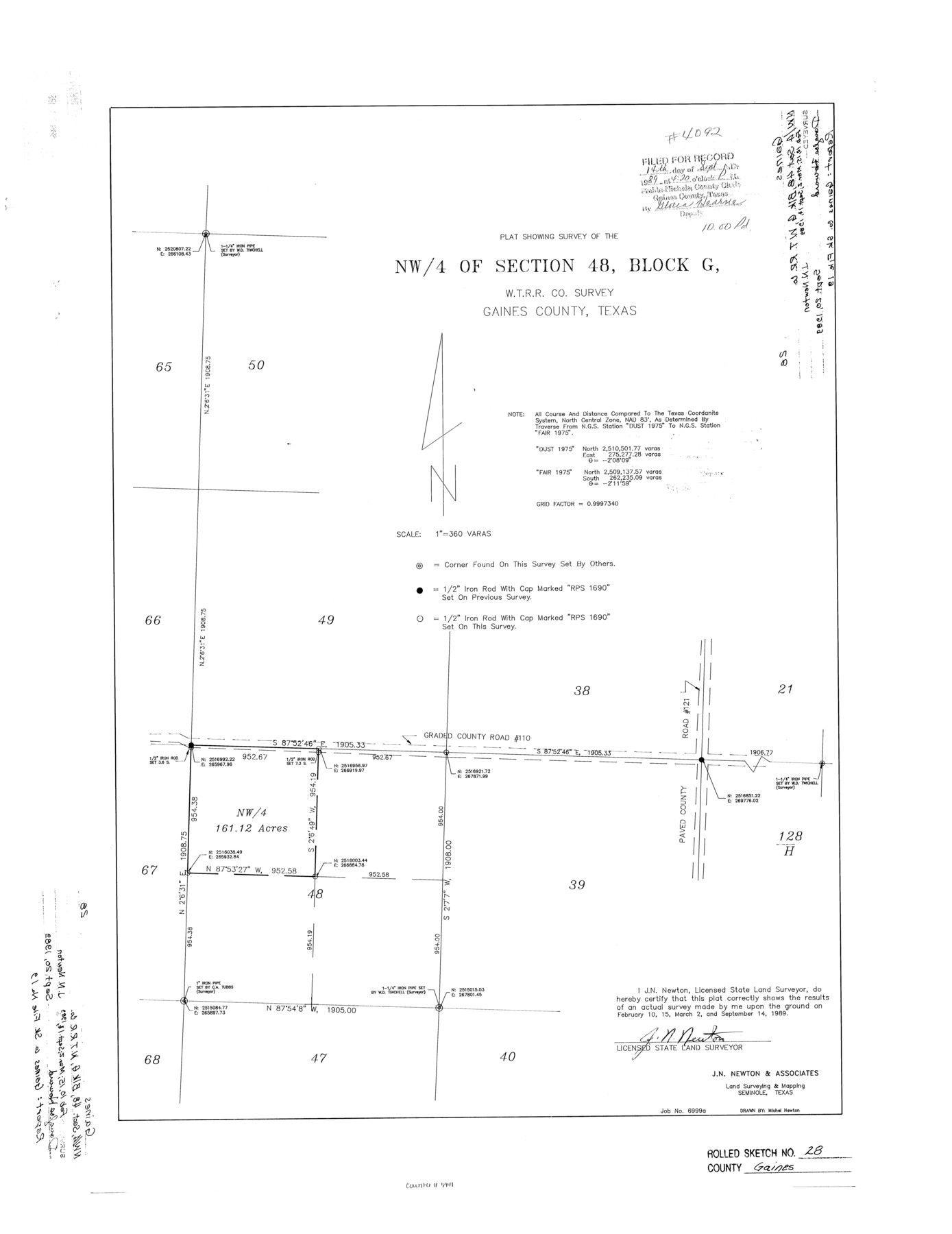
Gaines County Rolled Sketch 28
Plat showing survey of the NW/4 of section 48, Block G, W. T. R.R. Co. survey
-
Map/Doc
5941
-
Collection
General Map Collection
-
Object Dates
1989/9/14 (Creation Date)
1989/9/20 (File Date)
-
People and Organizations
J.N. Newton (Surveyor/Engineer)
Michel Newton (Draftsman)
-
Counties
Gaines
-
Subjects
Surveying Rolled Sketch
-
Height x Width
25.6 x 19.7 inches
65.0 x 50.0 cm
-
Medium
mylar, print
-
Scale
1" = 360 varas
-
Comments
See Gaines County Sketch File 19 (23331) for report.
Related maps
Gaines County Sketch File 19

Print $8.00
- Digital $50.00
Gaines County Sketch File 19
1989
Size 11.3 x 8.8 inches
Map/Doc 23331
Part of: General Map Collection
Jefferson County Sketch File 23

Print $20.00
- Digital $50.00
Jefferson County Sketch File 23
Size 15.8 x 17.8 inches
Map/Doc 11871
Montague County Working Sketch 8

Print $20.00
- Digital $50.00
Montague County Working Sketch 8
1928
Size 20.9 x 18.9 inches
Map/Doc 71074
Presidio County Boundary File 3a

Print $40.00
- Digital $50.00
Presidio County Boundary File 3a
Size 17.7 x 38.0 inches
Map/Doc 58074
Moore County Sketch File 11

Print $20.00
- Digital $50.00
Moore County Sketch File 11
Size 18.2 x 31.3 inches
Map/Doc 42129
Childress County Rolled Sketch 10

Print $20.00
- Digital $50.00
Childress County Rolled Sketch 10
1940
Size 43.6 x 12.0 inches
Map/Doc 8601
Crockett County Rolled Sketch 74

Print $20.00
- Digital $50.00
Crockett County Rolled Sketch 74
1949
Size 19.4 x 24.9 inches
Map/Doc 5615
Map of Tyler County

Print $20.00
- Digital $50.00
Map of Tyler County
1897
Size 42.0 x 37.5 inches
Map/Doc 16907
Comal County Working Sketch 2

Print $20.00
- Digital $50.00
Comal County Working Sketch 2
1940
Size 19.8 x 20.9 inches
Map/Doc 68168
Bee County Rolled Sketch 1

Print $20.00
- Digital $50.00
Bee County Rolled Sketch 1
2022
Size 24.4 x 36.0 inches
Map/Doc 97029
Rio Grande Rectification Project, El Paso and Juarez Valley

Print $20.00
- Digital $50.00
Rio Grande Rectification Project, El Paso and Juarez Valley
1935
Size 10.7 x 29.6 inches
Map/Doc 60866
Hardeman County Sketch File 32

Print $4.00
- Digital $50.00
Hardeman County Sketch File 32
Size 11.1 x 8.9 inches
Map/Doc 25068
Dimmit County Rolled Sketch 14

Print $40.00
- Digital $50.00
Dimmit County Rolled Sketch 14
1945
Size 56.6 x 36.0 inches
Map/Doc 8797
You may also like
Brazoria County Rolled Sketch AH

Print $20.00
- Digital $50.00
Brazoria County Rolled Sketch AH
Size 43.9 x 31.2 inches
Map/Doc 10714
Flight Mission No. BRE-2P, Frame 43, Nueces County

Print $20.00
- Digital $50.00
Flight Mission No. BRE-2P, Frame 43, Nueces County
1956
Size 18.8 x 22.7 inches
Map/Doc 86745
Bosque County

Print $40.00
- Digital $50.00
Bosque County
1945
Size 48.3 x 38.0 inches
Map/Doc 73083
Dallas County Sketch File 18a

Print $20.00
- Digital $50.00
Dallas County Sketch File 18a
Size 12.4 x 23.8 inches
Map/Doc 11286
Sabine and Neches Rivers

Print $20.00
- Digital $50.00
Sabine and Neches Rivers
1987
Size 19.6 x 44.7 inches
Map/Doc 69820
Map of Texas and the Countries Adjacent

Map of Texas and the Countries Adjacent
1844
Size 19.0 x 29.6 inches
Map/Doc 94561
Bandera County Sketch File 30A

Print $40.00
- Digital $50.00
Bandera County Sketch File 30A
Size 18.7 x 17.0 inches
Map/Doc 10899
Gonzales County Working Sketch 13

Print $2.00
- Digital $50.00
Gonzales County Working Sketch 13
1981
Size 12.5 x 7.6 inches
Map/Doc 63229
Andrews County Rolled Sketch 32

Print $20.00
- Digital $50.00
Andrews County Rolled Sketch 32
1950
Size 26.2 x 16.4 inches
Map/Doc 77176
Right of Way & Track Map, St. Louis, Brownsville & Mexico Ry. operated by St. Louis, Brownsville & Mexico Ry. Co.

Print $40.00
- Digital $50.00
Right of Way & Track Map, St. Louis, Brownsville & Mexico Ry. operated by St. Louis, Brownsville & Mexico Ry. Co.
1919
Size 25.4 x 56.9 inches
Map/Doc 64623
Denton County Sketch File 3

Print $4.00
- Digital $50.00
Denton County Sketch File 3
1855
Size 12.5 x 8.2 inches
Map/Doc 20688
Flight Mission No. DQO-8K, Frame 83, Galveston County

Print $20.00
- Digital $50.00
Flight Mission No. DQO-8K, Frame 83, Galveston County
1952
Size 18.7 x 22.3 inches
Map/Doc 85185