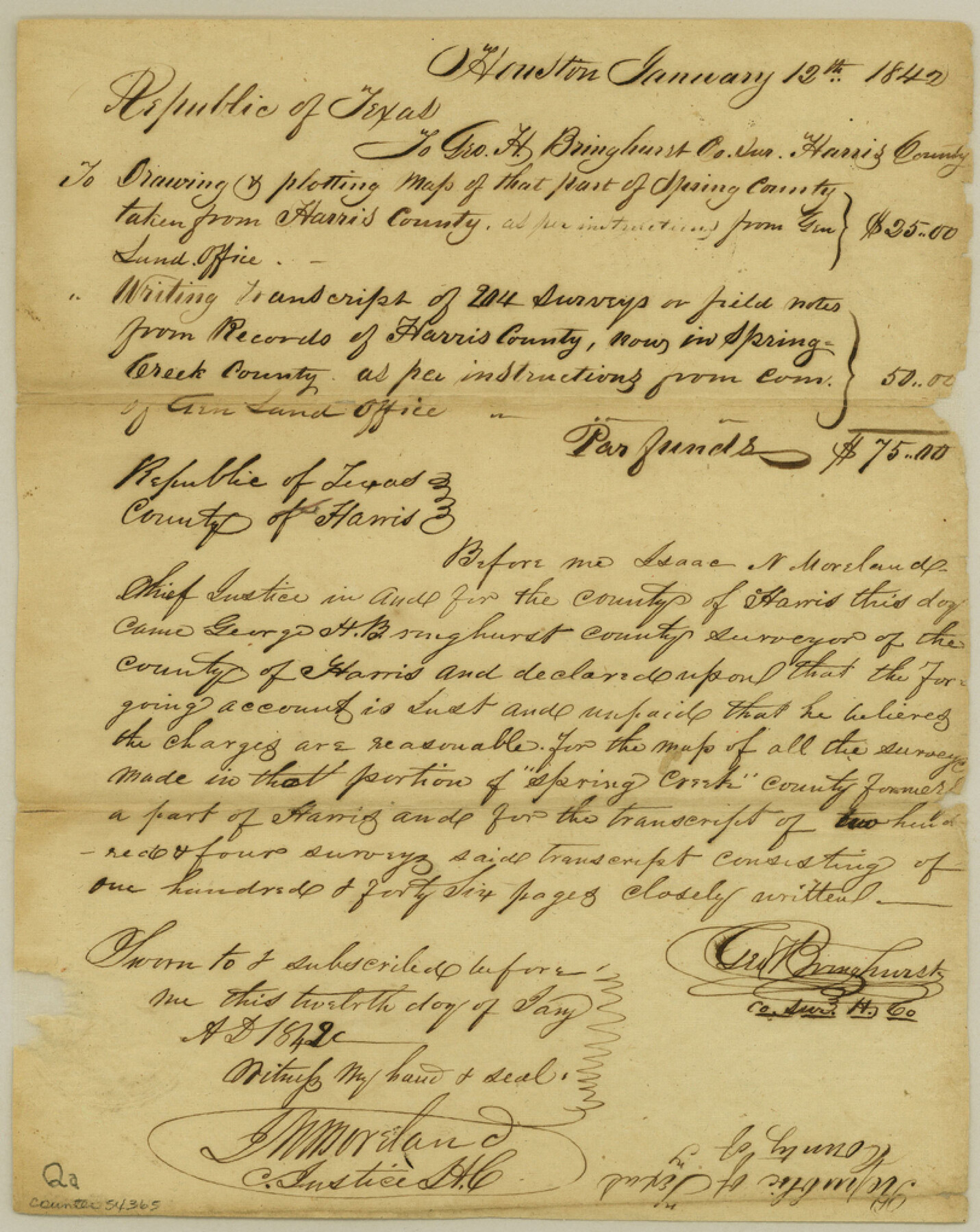
Harris County Boundary File 39 (21)
Harris & Montgomery Account of George H. Bringhurst for making a transcript of plot & fieldnotes of that part of Spring County taken from Harris County
-
Map/Doc
54365
-
Collection
General Map Collection
-
Counties
Harris
-
Subjects
County Boundaries
-
Height x Width
10.2 x 8.1 inches
25.9 x 20.6 cm
Part of: General Map Collection
Flight Mission No. DAH-17M, Frame 28, Orange County

Print $20.00
- Digital $50.00
Flight Mission No. DAH-17M, Frame 28, Orange County
1953
Size 18.5 x 22.3 inches
Map/Doc 86891
Right of Way & Track Map, The Texas & Pacific Ry. Co. Main Line

Print $20.00
- Digital $50.00
Right of Way & Track Map, The Texas & Pacific Ry. Co. Main Line
Size 11.0 x 19.0 inches
Map/Doc 64685
Survey plat of State Land, A. G. McMath No. 298, SF-10723 in El Paso County, Texas

Print $4.00
- Digital $50.00
Survey plat of State Land, A. G. McMath No. 298, SF-10723 in El Paso County, Texas
1984
Size 25.6 x 26.1 inches
Map/Doc 2254
[Capitol League Sketch E, Hockley County]
![1765, [Capitol League Sketch E, Hockley County], General Map Collection](https://historictexasmaps.com/wmedia_w700/maps/1765.tif.jpg)
Print $20.00
- Digital $50.00
[Capitol League Sketch E, Hockley County]
1910
Size 15.8 x 19.9 inches
Map/Doc 1765
Presidio County Rolled Sketch 68

Print $20.00
- Digital $50.00
Presidio County Rolled Sketch 68
1927
Size 11.8 x 24.4 inches
Map/Doc 7358
Wheeler County Working Sketch 14

Print $20.00
- Digital $50.00
Wheeler County Working Sketch 14
1979
Size 20.1 x 37.2 inches
Map/Doc 72503
Crane County Rolled Sketch 26

Print $20.00
- Digital $50.00
Crane County Rolled Sketch 26
2020
Size 36.5 x 24.5 inches
Map/Doc 96432
Crockett County Rolled Sketch 46A

Print $40.00
- Digital $50.00
Crockett County Rolled Sketch 46A
Size 43.4 x 63.9 inches
Map/Doc 9199
Chambers County Sketch File 30

Print $4.00
- Digital $50.00
Chambers County Sketch File 30
1859
Size 11.0 x 8.6 inches
Map/Doc 17612
Yoakum County Sketch File 8

Print $20.00
- Digital $50.00
Yoakum County Sketch File 8
Size 25.6 x 29.3 inches
Map/Doc 12705
Chambers County Sketch File 23

Print $2.00
- Digital $50.00
Chambers County Sketch File 23
1878
Size 10.0 x 7.9 inches
Map/Doc 17597
Louisiana and Texas Intracoastal Waterway

Print $20.00
- Digital $50.00
Louisiana and Texas Intracoastal Waterway
1937
Size 13.7 x 19.6 inches
Map/Doc 83348
You may also like
[San Antonio & Aransas Pass R.R. Right of Way from Eagle Lake to Brazos River]
![64256, [San Antonio & Aransas Pass R.R. Right of Way from Eagle Lake to Brazos River], General Map Collection](https://historictexasmaps.com/wmedia_w700/maps/64256.tif.jpg)
Print $40.00
- Digital $50.00
[San Antonio & Aransas Pass R.R. Right of Way from Eagle Lake to Brazos River]
1895
Size 30.8 x 124.9 inches
Map/Doc 64256
General Highway Map, Anderson County, Texas

Print $20.00
General Highway Map, Anderson County, Texas
1961
Size 18.3 x 25.0 inches
Map/Doc 79346
[Block B5, Capitol Leagues 217, 218, and 239]
![91438, [Block B5, Capitol Leagues 217, 218, and 239], Twichell Survey Records](https://historictexasmaps.com/wmedia_w700/maps/91438-1.tif.jpg)
Print $3.00
- Digital $50.00
[Block B5, Capitol Leagues 217, 218, and 239]
Size 15.1 x 10.0 inches
Map/Doc 91438
Garza County Sketch File 11

Print $4.00
- Digital $50.00
Garza County Sketch File 11
1901
Size 11.3 x 8.8 inches
Map/Doc 24066
Hockley County Rolled Sketch 3

Print $40.00
- Digital $50.00
Hockley County Rolled Sketch 3
Size 82.9 x 29.4 inches
Map/Doc 9173
Culberson County Sketch File 18

Print $8.00
- Digital $50.00
Culberson County Sketch File 18
Size 14.3 x 8.8 inches
Map/Doc 20185
Guadalupe County Working Sketch 2

Print $20.00
- Digital $50.00
Guadalupe County Working Sketch 2
1925
Size 37.2 x 19.2 inches
Map/Doc 63311
Working Sketch in Stephens-Palo Pinto Cos.

Print $20.00
- Digital $50.00
Working Sketch in Stephens-Palo Pinto Cos.
1919
Size 22.3 x 13.3 inches
Map/Doc 91918
Flight Mission No. BQY-14M, Frame 183, Harris County

Print $20.00
- Digital $50.00
Flight Mission No. BQY-14M, Frame 183, Harris County
1953
Size 18.5 x 22.4 inches
Map/Doc 85299
1968 Texas Official State Highway Map

Digital $50.00
1968 Texas Official State Highway Map
Size 28.1 x 36.5 inches
Map/Doc 94319
Loving County Working Sketch 24

Print $40.00
- Digital $50.00
Loving County Working Sketch 24
1952
Size 15.8 x 63.3 inches
Map/Doc 70658
Maverick County Sketch File 13a

Print $6.00
- Digital $50.00
Maverick County Sketch File 13a
1883
Size 14.1 x 8.8 inches
Map/Doc 31108