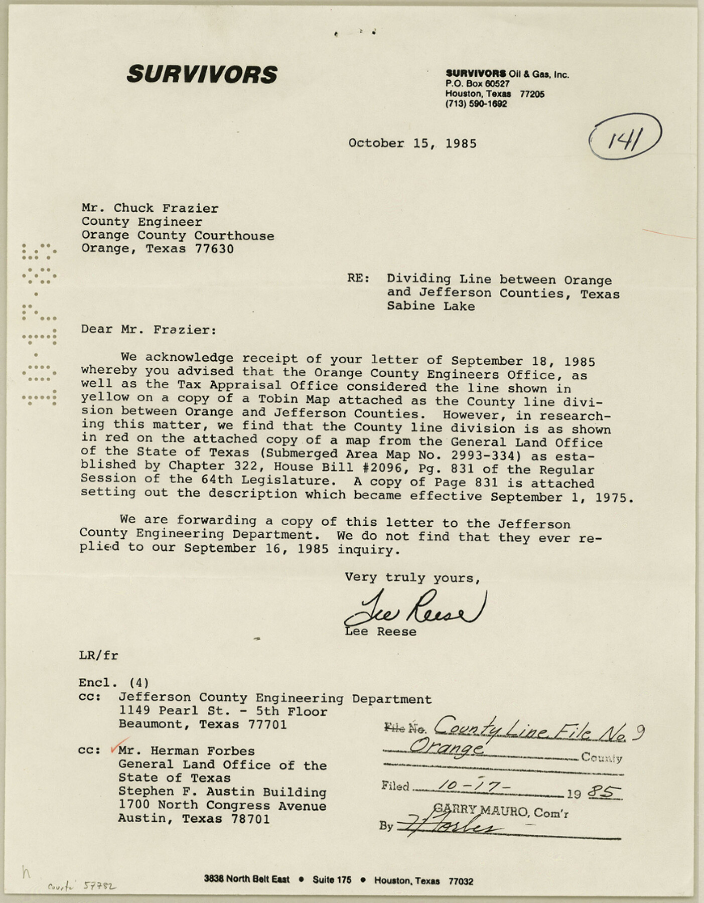
Orange County Boundary File 9
[Correspondence between Orange Co. Engineer and Survivors Oil & Gas, Inc. regarding Co. line as established by Chapter 322, HB #2096, Pg. 831 of the Regular Session of the 64th Legislature, effective 9-1-1975]
-
Map/Doc
57782
-
Collection
General Map Collection
-
Counties
Orange
-
Subjects
County Boundaries
-
Height x Width
11.2 x 8.7 inches
28.4 x 22.1 cm
Part of: General Map Collection
Aransas County Working Sketch 15

Print $20.00
- Digital $50.00
Aransas County Working Sketch 15
1956
Size 22.2 x 19.0 inches
Map/Doc 67182
Hardeman County Sketch File 3

Print $8.00
- Digital $50.00
Hardeman County Sketch File 3
1880
Size 14.2 x 8.8 inches
Map/Doc 24987
Reeves County Working Sketch 53

Print $40.00
- Digital $50.00
Reeves County Working Sketch 53
1977
Size 70.3 x 42.6 inches
Map/Doc 63496
Colorado River, New Gulf Sheet

Print $6.00
- Digital $50.00
Colorado River, New Gulf Sheet
1940
Size 24.0 x 34.9 inches
Map/Doc 65315
McMullen County Sketch File 15

Print $4.00
- Digital $50.00
McMullen County Sketch File 15
1876
Size 10.0 x 8.0 inches
Map/Doc 31363
Post Route Map of Texas (Inset 1: Dallas-Fort Worth Area; Inset 2: Texas Panhandle)

Print $40.00
- Digital $50.00
Post Route Map of Texas (Inset 1: Dallas-Fort Worth Area; Inset 2: Texas Panhandle)
1939
Size 56.8 x 39.2 inches
Map/Doc 93699
Tom Green County Sketch File 13

Print $4.00
- Digital $50.00
Tom Green County Sketch File 13
Size 6.3 x 8.4 inches
Map/Doc 38170
Crockett County Sketch File 75

Print $20.00
- Digital $50.00
Crockett County Sketch File 75
Size 26.3 x 28.8 inches
Map/Doc 11234
Coryell County Milam District

Print $20.00
- Digital $50.00
Coryell County Milam District
1883
Size 25.7 x 24.6 inches
Map/Doc 3446
Tom Green County Rolled Sketch 1

Print $20.00
- Digital $50.00
Tom Green County Rolled Sketch 1
Size 29.8 x 25.4 inches
Map/Doc 7991
Lampasas County Sketch File 4

Print $4.00
- Digital $50.00
Lampasas County Sketch File 4
1861
Size 12.3 x 8.2 inches
Map/Doc 29394
Eastland County Working Sketch 54

Print $20.00
- Digital $50.00
Eastland County Working Sketch 54
1984
Size 19.6 x 18.0 inches
Map/Doc 68835
You may also like
Donley County Working Sketch 4

Print $20.00
- Digital $50.00
Donley County Working Sketch 4
1958
Size 44.0 x 39.8 inches
Map/Doc 68737
Karte des Staates, Texas

Print $20.00
- Digital $50.00
Karte des Staates, Texas
1851
Size 25.5 x 30.8 inches
Map/Doc 2123
Upton County Sketch File 29

Print $40.00
- Digital $50.00
Upton County Sketch File 29
1935
Size 16.9 x 14.4 inches
Map/Doc 38881
St. Marks to Galveston - Sheet II

Print $20.00
- Digital $50.00
St. Marks to Galveston - Sheet II
1846
Size 26.5 x 40.5 inches
Map/Doc 97397
Trinity County Sketch File 35a

Print $6.00
- Digital $50.00
Trinity County Sketch File 35a
1921
Size 16.8 x 8.8 inches
Map/Doc 38587

Flight Mission No. CUI-1H, Frame 169, Milam County

Print $20.00
- Digital $50.00
Flight Mission No. CUI-1H, Frame 169, Milam County
1951
Size 18.7 x 22.6 inches
Map/Doc 86611
La Salle County Working Sketch 47

Print $20.00
- Digital $50.00
La Salle County Working Sketch 47
1982
Size 20.3 x 20.5 inches
Map/Doc 70348
Presidio County Rolled Sketch D2

Print $20.00
- Digital $50.00
Presidio County Rolled Sketch D2
1908
Size 14.3 x 16.9 inches
Map/Doc 7410
Gillespie County Sketch File 3a

Print $4.00
- Digital $50.00
Gillespie County Sketch File 3a
1860
Size 7.6 x 8.3 inches
Map/Doc 24131
Glasscock County Rolled Sketch 10

Print $20.00
- Digital $50.00
Glasscock County Rolled Sketch 10
Size 47.6 x 45.9 inches
Map/Doc 9058
Schleicher County Rolled Sketch 2

Print $20.00
- Digital $50.00
Schleicher County Rolled Sketch 2
1888
Size 25.8 x 32.6 inches
Map/Doc 7746