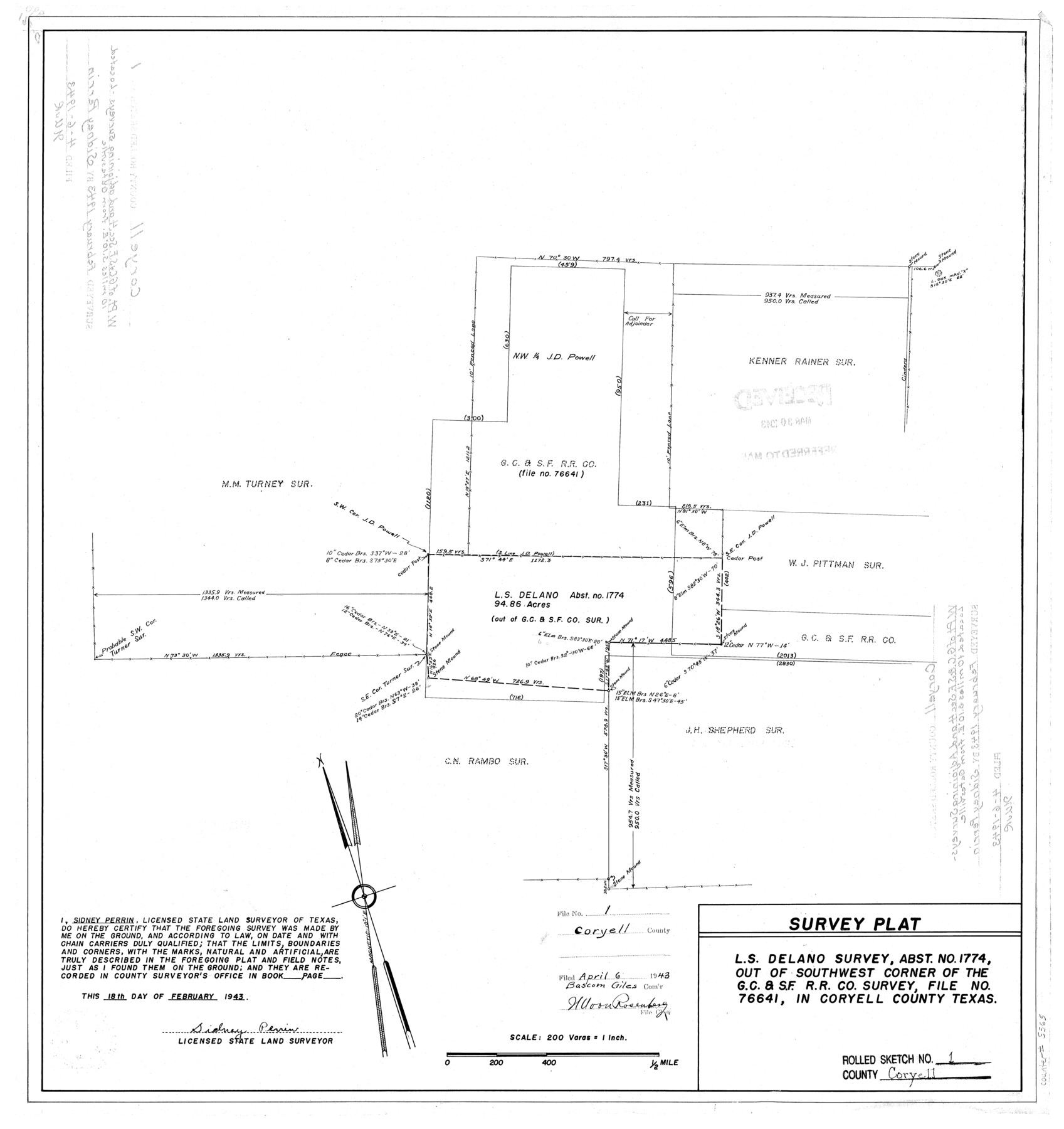
Coryell County Rolled Sketch 1
Survey plat, L.S. Delano survey, abst. no. 1774, out of southwest corner of the G. C. & S. F. R.R. Co. survey, file no. 76641
-
Map/Doc
5565
-
Collection
General Map Collection
-
Object Dates
1943/2/18 (Creation Date)
1943/4/6 (File Date)
-
People and Organizations
Sidney Perrin (Surveyor/Engineer)
-
Counties
Coryell
-
Subjects
Surveying Rolled Sketch
-
Height x Width
22.7 x 21.4 inches
57.7 x 54.4 cm
-
Scale
1" = 200 varas
Part of: General Map Collection
Kleberg County Rolled Sketch 10-27

Print $20.00
- Digital $50.00
Kleberg County Rolled Sketch 10-27
1952
Size 37.9 x 40.1 inches
Map/Doc 9402
Lubbock County Sketch File 2

Print $4.00
- Digital $50.00
Lubbock County Sketch File 2
Size 4.7 x 9.2 inches
Map/Doc 30418
Rains County Working Sketch 7

Print $20.00
- Digital $50.00
Rains County Working Sketch 7
1964
Size 32.6 x 38.6 inches
Map/Doc 71833
Val Verde County Sketch File 15a

Print $40.00
- Digital $50.00
Val Verde County Sketch File 15a
1885
Size 15.8 x 12.7 inches
Map/Doc 39217
Austin including Bergstrom AFB, Hays, Mansfield Dam, McKinney Falls State Park, Oak Hill, Rollingwood, San Leanna, Sunset Valley and West Lake Hills - also portions of Pflugerville

Austin including Bergstrom AFB, Hays, Mansfield Dam, McKinney Falls State Park, Oak Hill, Rollingwood, San Leanna, Sunset Valley and West Lake Hills - also portions of Pflugerville
Size 38.5 x 25.6 inches
Map/Doc 94376
Atascosa County Sketch File 26

Print $4.00
- Digital $50.00
Atascosa County Sketch File 26
Size 8.2 x 12.7 inches
Map/Doc 13794

Midland County Rolled Sketch 5

Print $20.00
- Digital $50.00
Midland County Rolled Sketch 5
Size 35.3 x 44.8 inches
Map/Doc 10695
Webb County Sketch File 9b

Print $20.00
- Digital $50.00
Webb County Sketch File 9b
1930
Size 15.9 x 16.5 inches
Map/Doc 12620
Andrews County Rolled Sketch 29

Print $20.00
- Digital $50.00
Andrews County Rolled Sketch 29
1949
Size 36.6 x 16.3 inches
Map/Doc 77173
Carte Reduit d'une partie des Côtes des Isles Australes

Print $20.00
- Digital $50.00
Carte Reduit d'une partie des Côtes des Isles Australes
1782
Size 12.7 x 17.3 inches
Map/Doc 97122
Brazos Island Harbor, Texas - Dredging Entrance Channel Plan

Print $20.00
- Digital $50.00
Brazos Island Harbor, Texas - Dredging Entrance Channel Plan
1990
Size 14.5 x 19.9 inches
Map/Doc 83339
You may also like
Railroad Commissioner's Map of Texas

Print $20.00
Railroad Commissioner's Map of Texas
1897
Size 27.0 x 23.0 inches
Map/Doc 90070
Map showing surveys involved in Cause No. 28888, State vs. Sullivan et al Travis County, Texas

Print $20.00
- Digital $50.00
Map showing surveys involved in Cause No. 28888, State vs. Sullivan et al Travis County, Texas
Size 23.0 x 40.7 inches
Map/Doc 75989
Controlled Mosaic by Jack Amman Photogrammetric Engineers, Inc - Sheet 25

Print $20.00
- Digital $50.00
Controlled Mosaic by Jack Amman Photogrammetric Engineers, Inc - Sheet 25
1954
Size 20.0 x 24.0 inches
Map/Doc 83476
Map of part of Presidio Co. Texas

Print $20.00
- Digital $50.00
Map of part of Presidio Co. Texas
Size 16.5 x 21.3 inches
Map/Doc 75769
Menard County Sketch File 29

Print $20.00
- Digital $50.00
Menard County Sketch File 29
1962
Size 21.0 x 41.1 inches
Map/Doc 10543
Right of Way and Track Map International & Gt. Northern Ry. operated by the International & Gt. Northern Ry. Co., Columbia Branch, Gulf Division

Print $40.00
- Digital $50.00
Right of Way and Track Map International & Gt. Northern Ry. operated by the International & Gt. Northern Ry. Co., Columbia Branch, Gulf Division
1917
Size 25.1 x 56.5 inches
Map/Doc 64598
Jasper County Rolled Sketch 2

Print $20.00
- Digital $50.00
Jasper County Rolled Sketch 2
1941
Size 22.5 x 16.6 inches
Map/Doc 6348
Flight Mission No. DAG-21K, Frame 92, Matagorda County

Print $20.00
- Digital $50.00
Flight Mission No. DAG-21K, Frame 92, Matagorda County
1952
Size 18.5 x 22.4 inches
Map/Doc 86421
Montgomery County Rolled Sketch 37

Print $40.00
- Digital $50.00
Montgomery County Rolled Sketch 37
Size 44.3 x 52.7 inches
Map/Doc 9544


[Scurry County]
![63030, [Scurry County], General Map Collection](https://historictexasmaps.com/wmedia_w700/maps/63030.tif.jpg)
Print $20.00
- Digital $50.00
[Scurry County]
1901
Size 34.3 x 42.5 inches
Map/Doc 63030