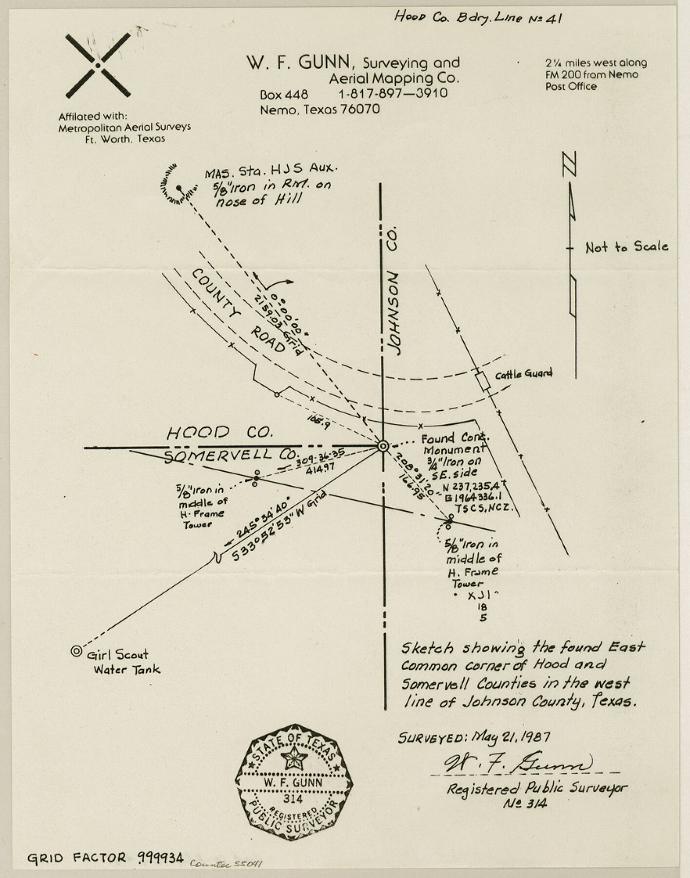
Hood County Boundary File 41
[Sketch showing location of NE cor. of Somervell Co., SE cor. of Hood Co., and west line of Johnson Co. State Plane Co-ordinates]
-
Map/Doc
55041
-
Collection
General Map Collection
-
Counties
Hood
-
Subjects
County Boundaries
-
Height x Width
11.2 x 8.8 inches
28.4 x 22.4 cm
Part of: General Map Collection
Lamar County State Real Property Sketch 1

Print $40.00
- Digital $50.00
Lamar County State Real Property Sketch 1
2013
Size 48.0 x 36.0 inches
Map/Doc 93655
Hardeman County Working Sketch 17

Print $20.00
- Digital $50.00
Hardeman County Working Sketch 17
1986
Size 18.4 x 26.1 inches
Map/Doc 63398
Victoria County Working Sketch 7

Print $40.00
- Digital $50.00
Victoria County Working Sketch 7
1945
Size 55.3 x 18.0 inches
Map/Doc 72277
Flight Mission No. DAG-14K, Frame 146, Matagorda County

Print $20.00
- Digital $50.00
Flight Mission No. DAG-14K, Frame 146, Matagorda County
1952
Size 18.4 x 22.2 inches
Map/Doc 86313
Uvalde County Rolled Sketch 22

Print $20.00
- Digital $50.00
Uvalde County Rolled Sketch 22
2002
Size 30.4 x 41.0 inches
Map/Doc 78656
PSL Field Notes for Blocks 87 through 98 in Culberson County

PSL Field Notes for Blocks 87 through 98 in Culberson County
Map/Doc 81664
Hansford County Working Sketch Graphic Index

Print $20.00
- Digital $50.00
Hansford County Working Sketch Graphic Index
1932
Size 39.2 x 38.2 inches
Map/Doc 76565
Anderson County Working Sketch 11

Print $40.00
- Digital $50.00
Anderson County Working Sketch 11
1933
Size 42.8 x 57.9 inches
Map/Doc 67010
Photo Index of Texas Coast - Sheet 5 of 6

Print $20.00
- Digital $50.00
Photo Index of Texas Coast - Sheet 5 of 6
1954
Size 20.0 x 24.0 inches
Map/Doc 83443
Randall County Working Sketch 3

Print $40.00
- Digital $50.00
Randall County Working Sketch 3
1934
Size 48.8 x 42.5 inches
Map/Doc 71840
Crockett County Rolled Sketch 46C

Print $20.00
- Digital $50.00
Crockett County Rolled Sketch 46C
1954
Size 25.3 x 31.6 inches
Map/Doc 5782

You may also like
Jeff Davis County Sketch File 22

Print $20.00
- Digital $50.00
Jeff Davis County Sketch File 22
1923
Size 19.4 x 25.0 inches
Map/Doc 11860
Gaines County Sketch File 1

Print $20.00
- Digital $50.00
Gaines County Sketch File 1
Size 19.1 x 30.7 inches
Map/Doc 11521
Zavala County Working Sketch 19

Print $40.00
- Digital $50.00
Zavala County Working Sketch 19
1978
Size 16.2 x 59.1 inches
Map/Doc 62094
Travis County Sketch File 37

Print $4.00
- Digital $50.00
Travis County Sketch File 37
Size 8.2 x 10.1 inches
Map/Doc 38357
Brazoria County Sketch File 10a

Print $50.00
- Digital $50.00
Brazoria County Sketch File 10a
1912
Size 7.1 x 8.7 inches
Map/Doc 14940
Cherokee County Working Sketch 2

Print $20.00
- Digital $50.00
Cherokee County Working Sketch 2
1932
Size 40.8 x 35.9 inches
Map/Doc 67957
Eastland County Working Sketch 12

Print $20.00
- Digital $50.00
Eastland County Working Sketch 12
1919
Size 23.8 x 21.1 inches
Map/Doc 68793
Maverick County Boundary File 1

Print $48.00
- Digital $50.00
Maverick County Boundary File 1
Size 14.2 x 8.7 inches
Map/Doc 56901
Red River County Working Sketch 39

Print $20.00
- Digital $50.00
Red River County Working Sketch 39
1967
Size 33.4 x 23.8 inches
Map/Doc 72022
United States - Gulf Coast - From Latitude 26° 33' to the Rio Grande Texas

Print $20.00
- Digital $50.00
United States - Gulf Coast - From Latitude 26° 33' to the Rio Grande Texas
1918
Size 18.3 x 24.1 inches
Map/Doc 72845
San Jacinto River and Tributaries, Texas - Survey of 1939

Print $20.00
- Digital $50.00
San Jacinto River and Tributaries, Texas - Survey of 1939
1939
Size 27.8 x 40.7 inches
Map/Doc 60308
Dawson County Sketch [showing T. & P. Blocks 34 and 33, Township 5 N]
![90546, Dawson County Sketch [showing T. & P. Blocks 34 and 33, Township 5 N], Twichell Survey Records](https://historictexasmaps.com/wmedia_w700/maps/90546-1.tif.jpg)
Print $2.00
- Digital $50.00
Dawson County Sketch [showing T. & P. Blocks 34 and 33, Township 5 N]
Size 12.6 x 7.0 inches
Map/Doc 90546